Issue Date: Sunday, June 26th, 2022
Issue Time: 9:50 AM MDT
Summary:
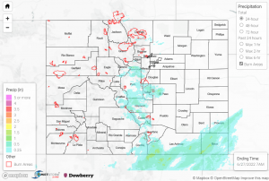
Yesterday we saw much-needed rainfall in many areas, mostly concentrated along the Urban Corridor and in the south-central portion of the state. Colorado Springs and the mountains to the west of the city seemed to have the heaviest precipitation- see the totals below for some notable observations. There was a flash flood warning issued yesterday evening for Chaffee County, but thankfully no flooding was reported.
-1.59” in Salida, with remarks of powerful rain for several hours beginning in the evening- this was southwest of the flash flood warning area
-0.64” in Hartsel
-1.16” reported in Colorado Springs, with many observations from the area of 0.5”-1”
-Pikes Peak received some snow!
Fresh couple inches of fresh snow atop Pikes Peak (14,115′)! Snow mainly above 13k feet in elevation in southern CO.#9wx #COwx pic.twitter.com/KldDKhmFUC
— Chris Bianchi (@BianchiWeather) June 26, 2022
For the Southeast Mountains and San Luis Valley, most observations were between 0.1” and 0.3”. Some areas received much higher amounts, including 0.53” in Canon City and 0.69” in Aguilar. Farther out west, Pagosa Springs received up to 0.38”, but the Southwestern Slope and mountains to the north and northwest only saw up to about 0.1” in most places from intermittent, light showers. Out east, the Southern Plains generally received 0.1”-0.4″.
The Denver area did not receive much rainfall at all yesterday, only up to a few hundredths of an inch. Northern Colorado received healthier totals. 0.24” in Greeley, 0.27” in Loveland, and 0.19” were the highest observations across the area, from seemingly calmer showers in the late afternoon and evening.
A few stream gages in Colorado Springs and south of the city area reporting high levels, but all are declining and none are near flood stage. There was no flooding reported yesterday. For precipitation estimates in your area, check out the map below.
Note: The Grand Junction radar is down for maintenance. This will impact the accuracy of QPE, especially in the southwestern portion of the state.
