Issue Date: Monday, June 27th, 2022
Issue Time: 11:15 AM MDT
Summary:
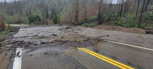
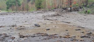
Another day of rain meant an eventful day for Colorado, the biggest news being a debris flow that occurred yesterday afternoon in Grand County, north of Granby. This debris flow occurred on the eastern portion of the East Troublesome burn scar, with precipitation totals near the debris flow area of up to 0.46”. It blocked off a section of CO 125- between County Road 54 and US 40 (Willowcreek Pass) from Mile Point 30.5 to Mile Point 0.01 is now closed. Via Grand County, there is no expected time for opening. Pictures below via the Grand County Sherriff’s Office show the debris flow in detail, and you can even see the burn scar behind it!
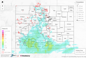
As far as rainfall goes, the heaviest precipitation occurred from the Southwest Slope over to the Southeast Mountains- totals of up to 1.61” across the southwest, particularly near Pagosa Springs and Durango. Most rainfall occurred due to storms in the late afternoon and evening. A flood advisory was issued for a large section near the western border of the state. While no flooding was reported within the advisory boundary, one CoCoRaHS reporter near the southern flood advisory boundary noted “some heavy field flooding on my 5 acres.” Moving eastward, totals south of Pueblo and in surrounding areas were anywhere from 0.2”-1.0”. East of Pueblo County in the Southeast Plains saw precipitation from 0” – 0.1” but up to 0.27” near Pinion Canyon.
The Northwest Slope and farther south in Grand Junction stayed relatively dry. However, east of Grand Junction saw some heavier totals in the mountains- 0.5” in Montrose, up to 1.0” near Salida, 0.68” in Crested Butte, to name a few. 0.25” hail was reported near Ridgway, Cimarron, and New Castle.
On the other side of the mountains, Colorado Springs received up to 0.5” observations, but rain was lighter and more consistent throughout the day than other parts of the state. Denver received only trace amounts of rainfall. Front Range totals to the east of the Urban Corridor, from southeast of Denver and farther north, were lighter as well, up to 0.3”-0.4” higher in the mountains but only a few hundredths of an inch at lower foothill elevations. Some small hail was reported in Rocky Mountain National Park along with the light showers. Last, a flood advisory was issued for a part of Larimer County over the Cameron Peak burn scar yesterday afternoon, but no flooding was reported for that area.
Note: The Grand Junction radar is down for maintenance. This will impact the accuracy of QPE, especially in the southwestern portion of the state.


