Issue Date: Friday, June 24th, 2022
Issue Time: 11:15 AM MDT
Summary:
Yesterday was eventful for Western Colorado, as west of the Divide saw significant rain and severe weather from north to south. In the southwest, precipitation totals included 0.62” west of Durango, and 0.77” in Ignacio close to the southern border. Thunderstorms moved through the area in the afternoon and into the later evening, bringing heavier rainfall and wind gusts of up to 49 mph.
Some other significant precipitation totals across the state include:
– 1.26” in Winter Park
-0.54” in Carbondale
-0.71” in Hotchkiss
-0.83” in Del Norte
-1.44” in just about an hour, across the border in Monticello, UT!
Grand Junction was a hub of activity yesterday, as well. Storms brought up to 0.46” over the evening in two short bursts. CoCoRaHS reports included observations of “small and sporadic hail”, and several others mentioned a good amount of thunder and lightning with the intermittent thunderstorms. Wind gusts of around 46 mph were observed along with these storms in Grand Junction and near Rifle to the east.
Additionally, three flood advisories for minor flooding (small streams, creeks, and arroyos) were issued throughout the afternoon and into the evening in areas surrounding Grand Junction to the north and south. One of the flood advisories for Mesa and Garfield counties was issued over the Pine Gulch burn scar, north of Grand Junction- however, no flooding was reported in any of the advisory areas. While none of the streams in the area are in flood stage, discharge certainly increased dramatically for many. The hydrograph below shows an increase of almost 300 cfs on the Dolores River near Gateway.
Outside of the Southwest Slope and around Grand Valley, the Central Mountains and Front Range received a a similar evening of numerous thunderstorms, as well, in many locations up to over 0.40”. East of the mountains into the I-25 corridor saw some slight trace amounts and was dry, although Pueblo saw up to 0.18” from some intermittent showers, including a brief thunderstorm and high winds. The Northern Plains also had some rainfall, up to 1.5” in Yuma County.
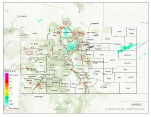
There was no flooding reported yesterday. For precipitation estimates in your area, check out the map below.
Note: The Grand Junction radar is down for maintenance. This will impact the accuracy of QPE, especially in the southwestern portion of the state.

