SPM 07-05-2022: Rinse and Repeat: Continued High Country Rainfall

Issue Date: Tuesday, July 5th, 2022
Issue Time: 11:00 AM MDT

Summary:

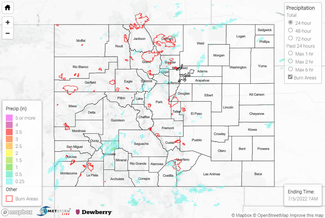
Independence Day was nearly a carbon copy of the synoptic setup of the past several days, albeit with slightly less moisture and instability. Subtropical moisture nonetheless remained overhead, and convection developed over the high country by early afternoon. Storm coverage was less than Sunday owing to the slightly drier atmosphere.

Showers and storms were confined to the mountains, valleys, and foothills across the state, with the eastern Plains remaining largely dry. The heaviest precipitation fell over the Front Range, Urban Corridor, and San Juan Mountains, where amounts of 0.25-0.50” were observed. Isolated totals of 0.75-1.25” were observed under some of the most intense cells, per QPE data.

Sparse storm coverage and lower precipitable water values limited the flooding threat yesterday, with only one Flood Advisory issued for small stream flooding in Larimer County.

Several fires were reported yesterday across the state as a result of firework usage, especially within the Denver metro area. Thankfully, fire crews were able to contain the fires quickly, including this brush fire near Aurora:

There was no flooding reported yesterday. For precipitation estimates in our area, check out the map below.
Click Here For Map Overview

The map below shows radar-estimated, rainfall gage-adjusted Quantitative Precipitation Estimates (QPE) across Colorado. The map is updated daily during the operational season (May 1 – Sep 30) by 11AM. The following six layers are currently available: 24-hour, 48-hour and 72-hour total precipitation, as well as maximum 1-hour, 2-hour and 6-hour precipitation over the past 24 hour period (to estimate where flash flooding may have occurred). The accumulation ending time is 7AM of the date shown in the bottom right corner. Also shown optionally are vulnerable fire burn areas (post 2012), which are updated throughout the season to include new, vulnerable burn areas. The home button in the top left corner resets the map to the original zoom.

SPM 07-04-2022: Showers and Storms Over High Terrain

Issue Date: Monday, July 4th, 2022
Issue Time: 11:45 AM MDT

Summary:

With an upper-level ridge centered to our south and east, broad south/southwesterly flow aloft kept a rich plume of moisture overhead, with precipitable water values once again 150-200% of normal. Weak lift associated with disturbances crossing the state, as well as additional lift from the right entrance region of a jet streak, helped to spark showers and storms over the mountains and valleys by mid-afternoon on Sunday.

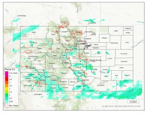
Locations that experienced showers and storms generally saw 0.25-0.75” of rainfall, with locally higher amounts observed under more intense storms. The heaviest rainfall across the state fell over the Palmer Ridge in Elbert County, where localized amounts exceeding 2.00” were observed, per QPE data.

The Boulder WFO issued three Flash Flood Warnings yesterday. Warnings were issued for central Larimer County, east-central Larimer County (including southeast portions of the Cameron Peak burn scar), and north-central Boulder County (including portions of the Calwood burn scar). Several Flood Advisories were also issued by the Boulder WFO, mainly for small stream and arroyo flooding. The Boulder Office of Emergency Management surveyed the Flash Flood Warning areas and thankfully found no flooding or debris flows; this is impressive, considering an automated gauge just west of the Calwood burn scar measured 0.43” of rainfall in 6 minutes!

There was no flooding reported yesterday. For precipitation estimates in our area, check out the map below.
Click Here For Map Overview

The map below shows radar-estimated, rainfall gage-adjusted Quantitative Precipitation Estimates (QPE) across Colorado. The map is updated daily during the operational season (May 1 – Sep 30) by 11AM. The following six layers are currently available: 24-hour, 48-hour and 72-hour total precipitation, as well as maximum 1-hour, 2-hour and 6-hour precipitation over the past 24 hour period (to estimate where flash flooding may have occurred). The accumulation ending time is 7AM of the date shown in the bottom right corner. Also shown optionally are vulnerable fire burn areas (post 2012), which are updated throughout the season to include new, vulnerable burn areas. The home button in the top left corner resets the map to the original zoom.

SPM 07-03-2022: More Showers and Storms

Issue Date: Sunday, July 3rd, 2022
Issue Time: 8:30 AM MDT

Summary:

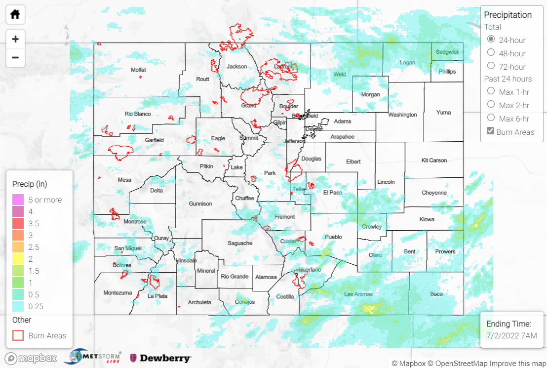
Monsoon moisture remained over Colorado on Saturday, albeit slightly less than previous days. Weak disturbances aloft helped to spark showers and storms once again, while weak severe weather parameters limited the threat with any storms to heavy rain and flash flooding.

The heaviest rainfall fell across the Southeast Mountains, Southeast Plains, and Raton Ridge, with amounts of 1-2+” under the most intense convection. A CoCoRaHS observer 3.5 miles north of Pueblo reported 1.65”, while a storm report near Pinon measured 2.49″. Storm coverage west of I-25 was once again widely scattered.

A Flash Flood Warning was issued for the Pack Creek burn scar, but no flooding was reported. Another Flash Flood Warning was issued for east-central Fremont County, southern El Paso County, and northwestern Pueblo County; flooding on I-25 near Pinon was reported, with 1-2’ of water and roads nearly impassible. Several Flood Advisories were also issued for small stream and arroyo flooding, although no flooding was reported.

A FTB user reported 0.42″ of rainfall in 10 minutes and minor street flooding in the Cimarron Hills neighborhood of Colorado Springs. Check out the flooding near Pueblo below:

For precipitation estimates in our area, check out the map below.
Click Here For Map Overview

The map below shows radar-estimated, rainfall gage-adjusted Quantitative Precipitation Estimates (QPE) across Colorado. The map is updated daily during the operational season (May 1 – Sep 30) by 11AM. The following six layers are currently available: 24-hour, 48-hour and 72-hour total precipitation, as well as maximum 1-hour, 2-hour and 6-hour precipitation over the past 24 hour period (to estimate where flash flooding may have occurred). The accumulation ending time is 7AM of the date shown in the bottom right corner. Also shown optionally are vulnerable fire burn areas (post 2012), which are updated throughout the season to include new, vulnerable burn areas. The home button in the top left corner resets the map to the original zoom.

SPM 07-02-2022: Continued Monsoonal Storms

Issue Date: Saturday, July 2nd, 2022
Issue Time: 11:15 AM MDT

Summary:

Showers and storms continued statewide on Friday as a mid-level plume of monsoonal moisture remained overhead, featuring precipitable water values 100-150% of normal (an evening sounding from Grand Junction featured 1.01” of precipitable water, over 170% of normal!). An upper-level disturbance tracking from the Four Corners across central Colorado combined with surface heating and upslope flow to produce widespread convection by mid-afternoon over the mountains.

Generally weak severe weather parameters limited the threat with any storms to heavy rainfall/flash flooding, as weak winds aloft produced slow storm motions, especially south of I-70. The heaviest rainfall was observed across the northern Northeast Plains, Southeast Mountains, Southeast Plains, Palmer Ridge, and Raton Ridge, where localized amounts of 1-2+” were observed under the most intense convection. Some notable rainfall reports include:

• 2.90” near Cedarwood, where numerous road washouts were reported by a CoCoRaHS observer
• 1.88” 13 miles north of Colorado Springs
• 1.70” 9 miles northeast of Iliff

Flash Flood Warnings were issued for south-central Chaffee County and central Fremont County, a few miles west and east of the Decker burn scar, respectively. A local sheriff reported rock/mudslides along Highway 285 just north of Poncha Pass, but no flooding was reported over the burn scar itself. Another Flash Flood Warning was issued for northern portions of the Spring Creek burn scar, with a gauge near La Veta (just east of the scar) reporting just under 0.50” of rainfall in about 15 minutes. Thankfully, no flooding was reported over this burn scar either. Two additional Flash Flood Warnings were issued for portions of Las Animas County, where the heaviest rainfall in the state looks to have fallen; QPE data suggests localized amounts approaching and exceeding 3” near the New Mexico border, and a gauge near Hoehne reported over 0.50” of rainfall in 10 minutes. A Flash Flood Watch was issued for the Grizzly Creek burn scar but was later cancelled with no flooding reported.

West of I-25, storm coverage was widely scattered, although two Flood Advisories were issued for mainly arroyo/small stream flooding. One of the advisories included far eastern portions of the Pine Gulch burn scar, although no flooding was reported.

Localized road flooding was also reported in some urban locations. Check out this video of street flooding in Colorado Springs:

For precipitation estimates in our area, check out the map below.

Click Here For Map Overview

The map below shows radar-estimated, rainfall gage-adjusted Quantitative Precipitation Estimates (QPE) across Colorado. The map is updated daily during the operational season (May 1 – Sep 30) by 11AM. The following six layers are currently available: 24-hour, 48-hour and 72-hour total precipitation, as well as maximum 1-hour, 2-hour and 6-hour precipitation over the past 24 hour period (to estimate where flash flooding may have occurred). The accumulation ending time is 7AM of the date shown in the bottom right corner. Also shown optionally are vulnerable fire burn areas (post 2012), which are updated throughout the season to include new, vulnerable burn areas. The home button in the top left corner resets the map to the original zoom.