Issue Date: Saturday, July 2nd, 2022
Issue Time: 11:15 AM MDT
Summary:
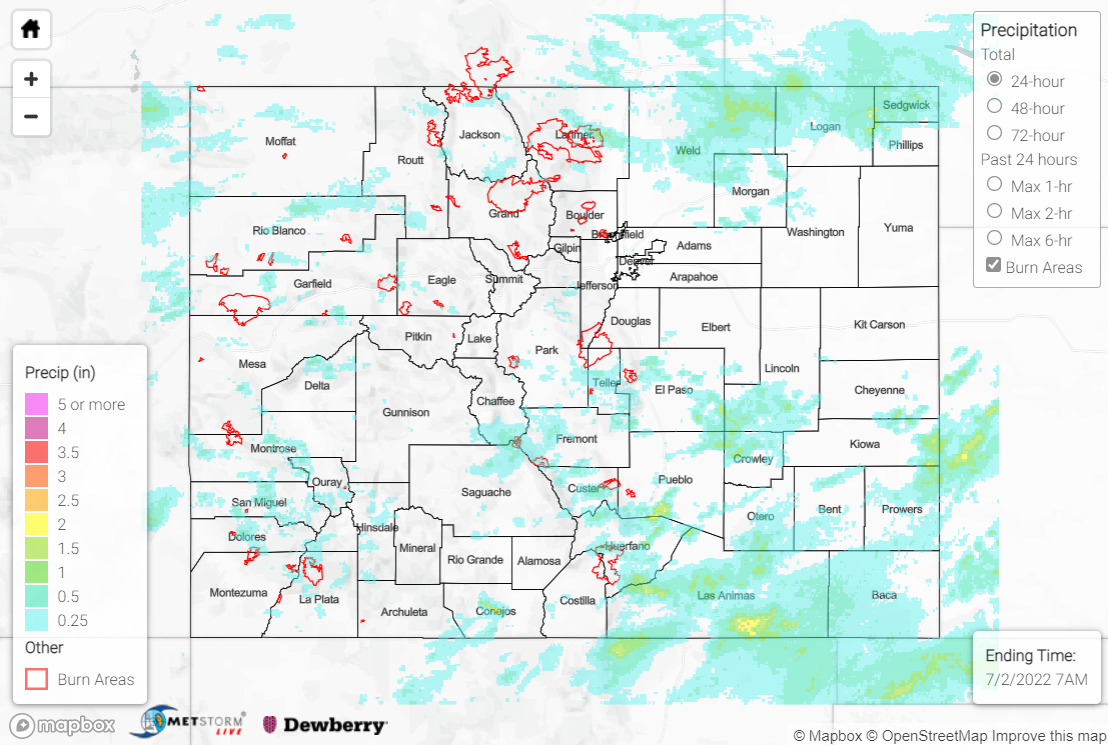
Showers and storms continued statewide on Friday as a mid-level plume of monsoonal moisture remained overhead, featuring precipitable water values 100-150% of normal (an evening sounding from Grand Junction featured 1.01” of precipitable water, over 170% of normal!). An upper-level disturbance tracking from the Four Corners across central Colorado combined with surface heating and upslope flow to produce widespread convection by mid-afternoon over the mountains.
Generally weak severe weather parameters limited the threat with any storms to heavy rainfall/flash flooding, as weak winds aloft produced slow storm motions, especially south of I-70. The heaviest rainfall was observed across the northern Northeast Plains, Southeast Mountains, Southeast Plains, Palmer Ridge, and Raton Ridge, where localized amounts of 1-2+” were observed under the most intense convection. Some notable rainfall reports include:
• 2.90” near Cedarwood, where numerous road washouts were reported by a CoCoRaHS observer
• 1.88” 13 miles north of Colorado Springs
• 1.70” 9 miles northeast of Iliff
Flash Flood Warnings were issued for south-central Chaffee County and central Fremont County, a few miles west and east of the Decker burn scar, respectively. A local sheriff reported rock/mudslides along Highway 285 just north of Poncha Pass, but no flooding was reported over the burn scar itself. Another Flash Flood Warning was issued for northern portions of the Spring Creek burn scar, with a gauge near La Veta (just east of the scar) reporting just under 0.50” of rainfall in about 15 minutes. Thankfully, no flooding was reported over this burn scar either. Two additional Flash Flood Warnings were issued for portions of Las Animas County, where the heaviest rainfall in the state looks to have fallen; QPE data suggests localized amounts approaching and exceeding 3” near the New Mexico border, and a gauge near Hoehne reported over 0.50” of rainfall in 10 minutes. A Flash Flood Watch was issued for the Grizzly Creek burn scar but was later cancelled with no flooding reported.
West of I-25, storm coverage was widely scattered, although two Flood Advisories were issued for mainly arroyo/small stream flooding. One of the advisories included far eastern portions of the Pine Gulch burn scar, although no flooding was reported.
Localized road flooding was also reported in some urban locations. Check out this video of street flooding in Colorado Springs:
Reminder to not drive into waters of unknown depth. Apparently some significant water is on the road near Voyager and North Gate. #COWX @CSTMC @KKTV11News #ColoradoSprings https://t.co/0JRd8ZSe2J
— Pikes Peak Amateur Radio Emergency Service (ARES) (@PikesPeakARES) July 1, 2022
For precipitation estimates in our area, check out the map below.
