Issue Date: Sunday, July 3rd, 2022
Issue Time: 8:30 AM MDT
Summary:
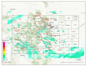
Monsoon moisture remained over Colorado on Saturday, albeit slightly less than previous days. Weak disturbances aloft helped to spark showers and storms once again, while weak severe weather parameters limited the threat with any storms to heavy rain and flash flooding.
The heaviest rainfall fell across the Southeast Mountains, Southeast Plains, and Raton Ridge, with amounts of 1-2+” under the most intense convection. A CoCoRaHS observer 3.5 miles north of Pueblo reported 1.65”, while a storm report near Pinon measured 2.49″. Storm coverage west of I-25 was once again widely scattered.
A Flash Flood Warning was issued for the Pack Creek burn scar, but no flooding was reported. Another Flash Flood Warning was issued for east-central Fremont County, southern El Paso County, and northwestern Pueblo County; flooding on I-25 near Pinon was reported, with 1-2’ of water and roads nearly impassible. Several Flood Advisories were also issued for small stream and arroyo flooding, although no flooding was reported.
A FTB user reported 0.42″ of rainfall in 10 minutes and minor street flooding in the Cimarron Hills neighborhood of Colorado Springs. Check out the flooding near Pueblo below:
Flash Flood Warning: I25 north of Pueblo, Highway 50 west of Pueblo through 8pm. – https://t.co/n3dUYCRluj https://t.co/UdpvASKJeN #Flooding #Storms #Disaster
— Global News Report (@robinsnewswire) July 3, 2022
For precipitation estimates in our area, check out the map below.
