SPM 07-29-2022: Rain for Northern, Southern Thirds of the State

Issue Date: Friday, July 29th, 2022
Issue Time: 9:30 AM MDT

Summary:

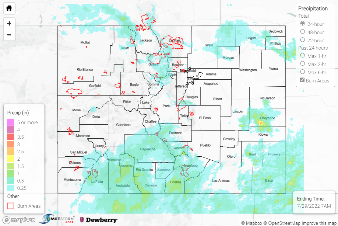
Lingering clouds from earlier convection to start the day on Thursday delayed and limited surface heating and associated convective development. Plentiful monsoonal moisture was in place and where clearing occurred later in the day, storms were able to develop over the high terrain. Rainfall was generally limited to the northern and southern thirds of the state.

Across the Northern Mountains, northern Front Range/Urban Corridor, and northern Northeast Plains, QPE data suggests 0.25-0.75” of rain was observed, with localized amounts up to and exceeding 1.00”. Notable rainfall totals at lower elevations include 1.00” and 0.93” in Fort Collins, while at higher elevations, 0.86” and 0.71” were observed north of Hot Sulphur Springs over the East Troublesome burn scar. Flash Flood Warnings and Flood Advisories were issued for both the East Troublesome and Cameron Peak burn scars, but no flooding was reported. Additional Flood Advisories were issued for northern Jackson County, portions of Douglas and Jefferson Counties, and the central Northeast Plains, but no flooding was reported in these locations.

Across the Southwest Slope, San Juan Mountains, and Southeast Mountains, QPE data suggests widespread amounts of 0.50-1.00”. However, as mentioned in yesterday’s SPM, the Grand Junction radar is offline, so these QPE totals are likely underestimated, and rain gauge data confirms this. CoCoRaHS observers reported amounts as high as 1.63” near Pagosa Springs, while gauges near Durango, Saguache, and San Acacio measured 1.50”, 1.39”, and 1.18”, respectively. A Flash Flood Warning was issued for the Spring Creek burn scar, but no flooding was reported. Flood Advisories were issued for southern portions of the Southwest Slope and San Juans, with forecasters using satellite and lightning frequency data to infer heavy rainfall and issue the advisories, but no flooding was reported in these regions, either.

Across the eastern Southeast Plains, QPE data suggests isolated totals exceeding 1.00”, particularly across central Cheyenne, northern Kiowa, Bent, southern Prowers, and Baca Counties. Notable rain gauge observations in this vicinity include 1.91” near Walsh, 1.20” near Springfield, and 0.96” near Two Buttes.

If you observe flooding in your area, remember to use the “Report a Flood” page to make any flood reports when you can safely do so. For precipitation estimates in our area, check out the map below.
Click Here For Map Overview

The map below shows radar-estimated, rainfall gage-adjusted Quantitative Precipitation Estimates (QPE) across Colorado. The map is updated daily during the operational season (May 1 – Sep 30) by 11AM. The following six layers are currently available: 24-hour, 48-hour and 72-hour total precipitation, as well as maximum 1-hour, 2-hour and 6-hour precipitation over the past 24 hour period (to estimate where flash flooding may have occurred). The accumulation ending time is 7AM of the date shown in the bottom right corner. Also shown optionally are vulnerable fire burn areas (post 2012), which are updated throughout the season to include new, vulnerable burn areas. The home button in the top left corner resets the map to the original zoom.

SPM 07-28-2022: Heavy Rain and Large Hail for Northern Front Range/Urban Corridor, Eastern Northeast Plains

Issue Date: Thursday, July 28th, 2022
Issue Time: 11:15 AM MDT

Summary:

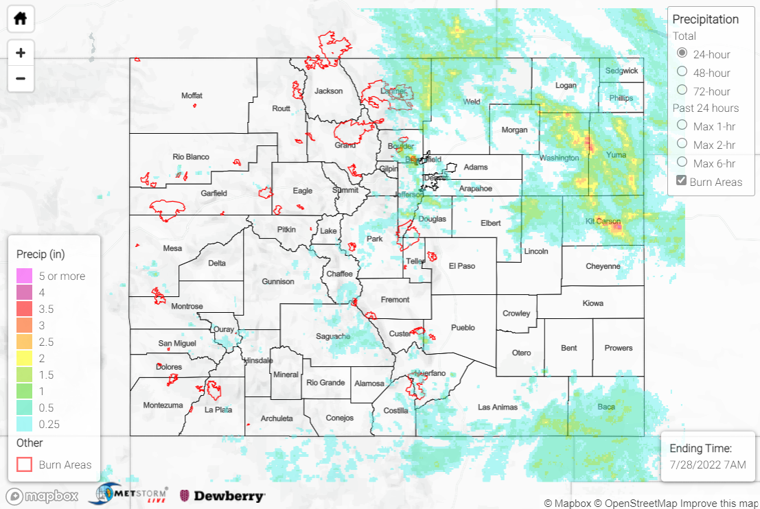
The active pattern continued across Colorado on Wednesday with more heavy rainfall and severe weather. Showers and storms developed with diurnal heating by mid to late afternoon over the high terrain, while a frontal boundary over the eastern Plains provided forcing for additional rounds of storms later in the evening. The heaviest rain fell across northern portions of the Front Range/Urban Corridor, as well as eastern portions of the Northeast Plains.

For the northern Front Range, two Flash Flood Warnings and one Flood Advisory were issued for portions of the Cameron Peak burn scar, although no flooding was reported. Hail up to 1.5” was observed, with one hail report mentioning over 0.50” of rain falling in only 15 minutes. Check out the photo below of leftover hail in Estes Park this morning:

Across the Fort Collins area, QPE data suggests rainfall amounts of 1.5-2.5” were widespread. Notable CoCoRaHS observations include 2.62” near Wellington and 2.55” in Fort Collins. A Flood Advisory was issued for urban and small stream flooding, and the area was blanketed in Severe Thunderstorm Warnings for hail up to 2.5” (tennis ball-sized). Dents in cars, damaged shingles, and downed tree limbs were all reported, although flooding was not.

For the Denver-Boulder metropolitan area, QPE data suggests amounts of 1.5-2.5” in some locations. The heaviest rain fell southeast of Boulder, where CoCoRaHS observations of 2.74” and 2.34” were received, while near Denver the heaviest rain fell south and west of the city. 1.85” and 1.51” were measured near the suburbs of Littleton and Beverly Hills, respectively. 1” hail was reported along with a 66-mph gust near Centennial, and Flash Flood Warnings/Flood Advisories were issued, but no flooding was reported. Another Flash Flood Warning was issued for central Park County, but again no flooding was reported.

For the Northeast Plains, the heaviest rain fell from Washington/Yuma Counties south-southeastward into Kit-Carson County. QPE data suggests amounts of up to 3-4” occurred in this vicinity, but these estimates might be biased slightly upwards due to contamination from large hail; rain gauges in Akron and Stratton measured 2.55” and 2.40”, respectively. A Flood Advisory was issued north of Fort Morgan, while numerous Flash Flood Warnings, Flood Advisories, and Severe Thunderstorm Warnings blanketed the state from Sterling to Burlington. Several inches of water were reported flowing over Highway 61 at County Roads 44 and 51, along with flooding of fields in the area. Near Wray, over 3” hail was reported along with a gust at a mesonet station of 71 mph. A Flood Advisory was issued for Elbert and Lincoln Counties on the northern side of the Palmer Ridge, where QPE data suggests 1-2” of rain fell, and 1.85” was measured by a gauge north of Limon.

Across the Southeast Mountains, Flash Flood Warnings were issued for eastern Custer/southwestern Pueblo Counties as well as for the Spring Creek burn scar, but no flooding was reported. Rain gauge coverage is sparse, but QPE data suggests localized amounts up to 1.5”. For far western portions of the state, several Flood Advisories were issued across the Southwest Slope, Grand Valley, and Northwest Slope, but no flooding was reported. The Grand Junction radar is currently offline (and will be through August 2) so QPE data is missing or greatly underestimated in these regions, but amounts of 2.22”, 1.99”, and 0.99” were measured by gauges near Durango. 1.42” of that 2.22” 24-hour total occurred in just 25 minutes, which has an estimated ARI of over 36 years!

If you observe flooding in your area, remember to use the “Report a Flood” page to make any flood reports when you can safely do so. For precipitation estimates in our area, check out the map below.

Click Here For Map Overview

The map below shows radar-estimated, rainfall gage-adjusted Quantitative Precipitation Estimates (QPE) across Colorado. The map is updated daily during the operational season (May 1 – Sep 30) by 11AM. The following six layers are currently available: 24-hour, 48-hour and 72-hour total precipitation, as well as maximum 1-hour, 2-hour and 6-hour precipitation over the past 24 hour period (to estimate where flash flooding may have occurred). The accumulation ending time is 7AM of the date shown in the bottom right corner. Also shown optionally are vulnerable fire burn areas (post 2012), which are updated throughout the season to include new, vulnerable burn areas. The home button in the top left corner resets the map to the original zoom.

SPM 07-27-2022: Active Tuesday!

Issue Date: Wednesday, July 27th, 2022
Issue Time: 11:30 AM MDT

Summary:

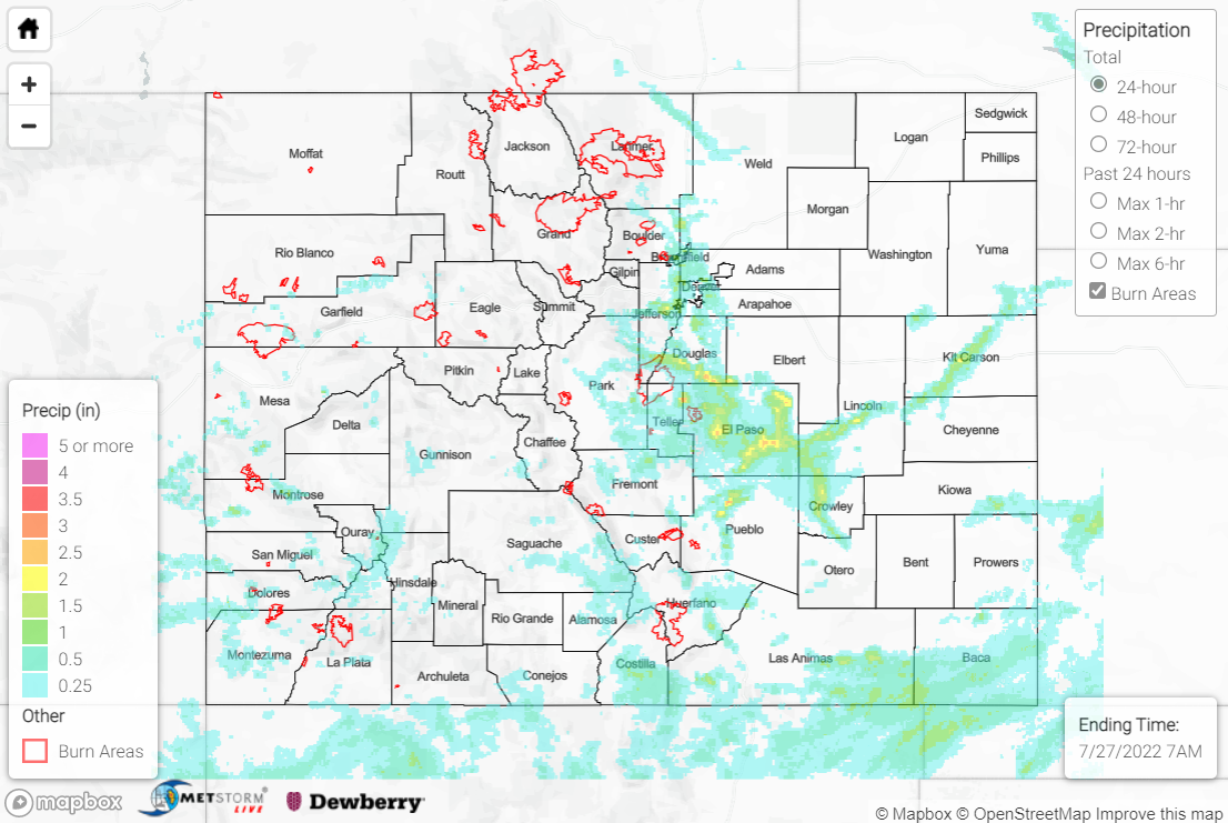
Tuesday saw extremely active weather across the state, with tornadoes, flooding, hail, and high winds. Showers and storms formed over the high terrain by early afternoon, with the most intense convection developing over the southern Front Range and its foothills and building south-southeastward. A cool front tracking slowly southward across eastern Colorado provided surface convergence for convective initiation, while diurnal heating and orographic ascent also helped storms to build. The heaviest rainfall occurred east of the Divide, along the I-25 corridor from Denver southward to Pueblo and then eastward across the Palmer Ridge and into Kit-Carson County.

Four Flood Advisories were issued for the greater Denver metropolitan area where 1-2” of rain was observed. Video posted to Twitter showed flooding on I-25 near the I-70 junction:

Numerous reports of hail up to quarter-size (1.00”) were received southeast of Denver, while a mesonet station recorded a 63-mph thunderstorm wind gust. The public reported large tree limbs down and power poles broken. Two more Flood Advisories were also issued for southern Douglas and Jefferson Counties, but no flooding was reported. Notable rainfall observations in the Denver area include:

• 1.76” east of Highlands Ranch
• 1.75” near Centennial
• 1.73” east of Lakewood
• 1.61” near Broomfield

Further south along I-25, the Colorado Springs area experienced significant flooding, with QPE estimates of up to 2.5” of rain. Multiple Flash Flood Warnings, Flood Warnings, and Flood Advisories were issued for eastern Teller and western El Paso Counties. Cars were reported stuck in the road, with street and curbside flooding near the Colorado Springs Airport.

One of the Flood Advisories was issued for Fountain Creek, with the creek cresting overnight just below flood stage. Numerous creeks and streams along the I-25 corridor experienced significant rises with yesterday’s rainfall.

East of Colorado Springs across eastern El Paso County, two Flash Flood Warnings were issued. The public reported significant flooding north of Truckton, along with a road washed out northeast of Calhan. Notable rainfall observations in the Colorado Springs area include:

• 3.02” east-southeast of Larkspur
• 2.13” near Fort Carson (0.61” fell in just 10 minutes, which has an estimated ARI of just under 10 years)
• 1.89” north of Woodland Park

Continuing south along I-25, the Pueblo metropolitan area also saw significant rainfall, with QPE estimates of up to 3” of rainfall north of the city. Flash Flood Warnings and Flood Warnings were issued, with numerous reports of stranded/submerged cars and streets closed due to high water. A NWS employee reported large tree limbs down, and a 57-mph gust was measured in the area. Notable rainfall observations in the Pueblo area include 0.94”, 0.92”, and 0.89” all near Pueblo West.

Across south-central and southwestern portions of the state, heavy rainfall was also observed. Two Flood Advisories were issued for western Montrose County on the Southwest Slope, but no flooding was reported. A Flash Flood Warning and Flood Warning were issued for south-central Costilla County, with emergency management reporting flooding along County Road R near San Luis. A mudslide occurred along Highway 550 on Red Mountain Pass near Ironton, although no Flood Warnings or Advisories were issued for this area. Rain gauge coverage is sparse but notable rainfall observations include 0.97” and 0.74” in the western San Juans, as well as 0.93” west of Trinidad.

Lastly, numerous tornado reports were received in Kit-Carson County along I-70 near Seibert, Vona, and Stratton. Damage and debris were reported, and the Goodland WFO confirmed an EF-0 tornado with estimated wind speeds of 65-85 mph. 1.25” hail was reported in the area, while 0.74” and 0.73” of rainfall was measured in Seibert and Stratton, respectively.

If you observe flooding in your area, remember to use the “Report a Flood” page to make any flood reports when you can safely do so. For precipitation estimates in our area, check out the map below.
Click Here For Map Overview

The map below shows radar-estimated, rainfall gage-adjusted Quantitative Precipitation Estimates (QPE) across Colorado. The map is updated daily during the operational season (May 1 – Sep 30) by 11AM. The following six layers are currently available: 24-hour, 48-hour and 72-hour total precipitation, as well as maximum 1-hour, 2-hour and 6-hour precipitation over the past 24 hour period (to estimate where flash flooding may have occurred). The accumulation ending time is 7AM of the date shown in the bottom right corner. Also shown optionally are vulnerable fire burn areas (post 2012), which are updated throughout the season to include new, vulnerable burn areas. The home button in the top left corner resets the map to the original zoom.

SPM 07-26-2022: More Rain for Southern High Terrain, Southeast Plains

Issue Date: Tuesday, July 26th, 2022
Issue Time: 10:30 AM MDT

Summary:

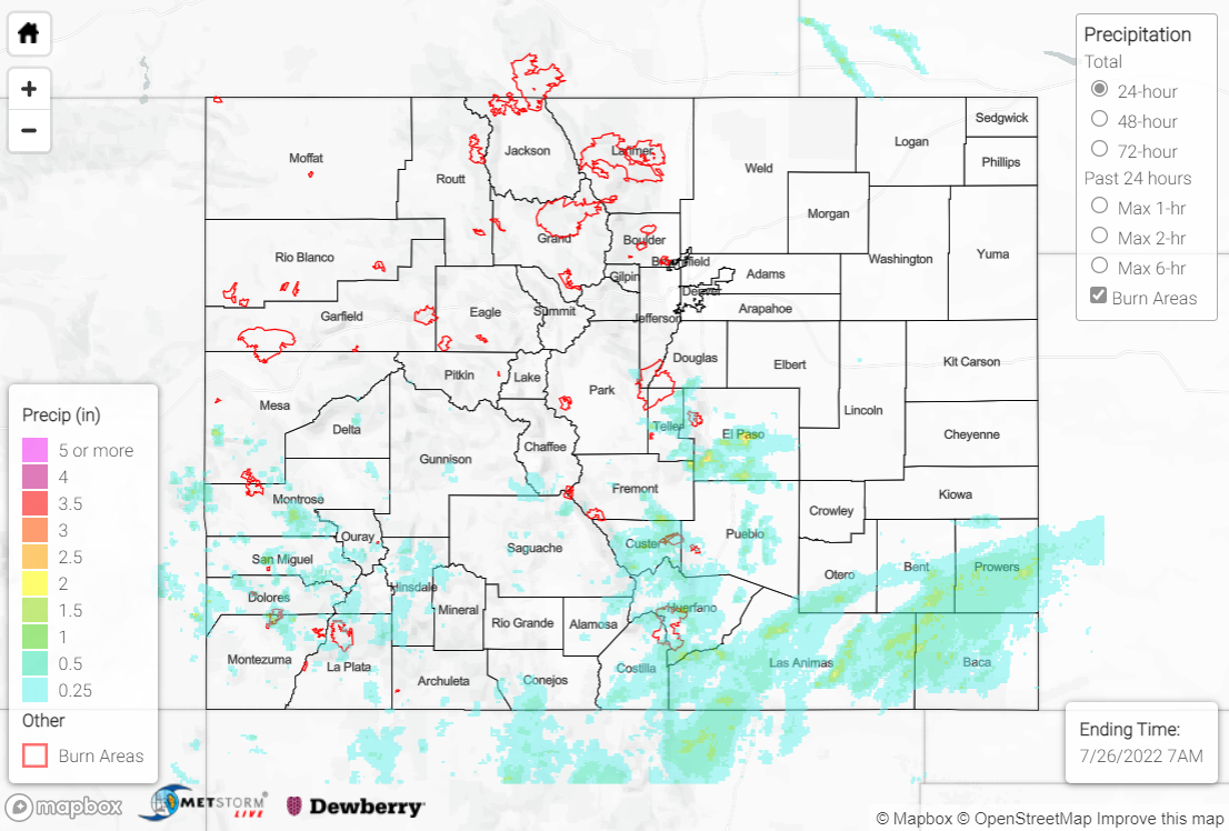
Northwest flow aloft led to drying on Monday across northern Colorado, while Sunday’s monsoonal moisture lingered over the southern half of the state. Showers and storms developed with diurnal heating by early afternoon across the high terrain south of I-70, while ascent along a surface boundary helped precipitation eventually extend across southern portions of the Southeast Plains.

The heaviest rain fell across the western Palmer Ridge and far southern Urban Corridor, where QPE data suggests localized amounts up to 2.50” were observed. Gauge observations in this vicinity include:

• 1.70” west of Colorado Springs Airport
• 1.20” east of Pueblo Memorial Airport
• 0.81” south of Fort Carson

At Colorado Springs Airport, 1.47” of that 24-hour total was observed in 30 minutes, which has an estimated ARI of over 21 years! Flash Flood Warnings were issued for southwest, south-central, and central El Paso County, as well as north-central Pueblo County. Local media relayed reports of minor road flooding in the Security-Widefield area; 1” hail was also reported west of Fountain.

Elsewhere, across the San Juans, Southeast Mountains, and Raton Ridge, QPE data suggests amounts of 0.50-1.50” were observed. For the southern Southeast Plains, rain gauge coverage is sparse, but QPE data suggests some locations received up to 2.00”. Noteworthy gauge observations in this region include:

• 1.09” near Trinidad Lake
• 0.97” near Trinidad
• 0.89” near Walsenburg
• 0.75” near Pagosa Springs
• 0.75” near La Veta

Several road flooding reports were received yesterday from the public and local law enforcement across Kit-Carson and Cheyenne Counties, but this flooding was a continuation from Sunday night’s heavy rainfall.

If you observe flooding in your area, remember to use the “Report a Flood” page to make any flood reports when you can safely do so. For precipitation estimates in our area, check out the map below.
Click Here For Map Overview

The map below shows radar-estimated, rainfall gage-adjusted Quantitative Precipitation Estimates (QPE) across Colorado. The map is updated daily during the operational season (May 1 – Sep 30) by 11AM. The following six layers are currently available: 24-hour, 48-hour and 72-hour total precipitation, as well as maximum 1-hour, 2-hour and 6-hour precipitation over the past 24 hour period (to estimate where flash flooding may have occurred). The accumulation ending time is 7AM of the date shown in the bottom right corner. Also shown optionally are vulnerable fire burn areas (post 2012), which are updated throughout the season to include new, vulnerable burn areas. The home button in the top left corner resets the map to the original zoom.