Issue Date: Thursday, July 28th, 2022
Issue Time: 11:15 AM MDT
Summary:
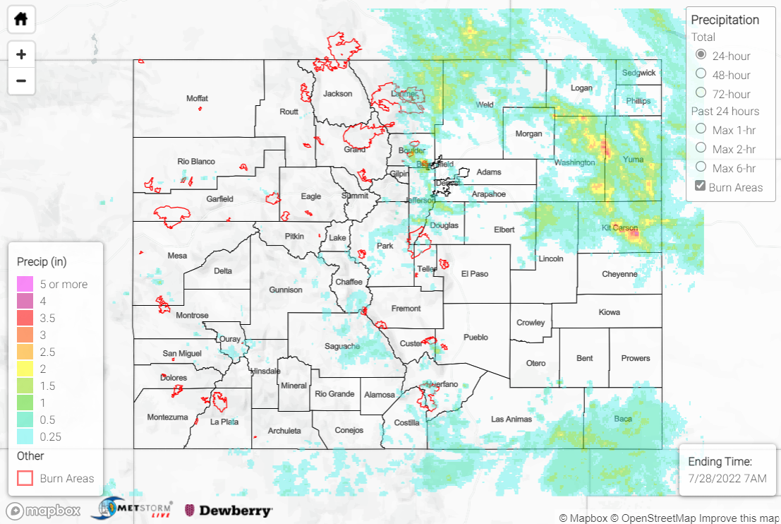
The active pattern continued across Colorado on Wednesday with more heavy rainfall and severe weather. Showers and storms developed with diurnal heating by mid to late afternoon over the high terrain, while a frontal boundary over the eastern Plains provided forcing for additional rounds of storms later in the evening. The heaviest rain fell across northern portions of the Front Range/Urban Corridor, as well as eastern portions of the Northeast Plains.
For the northern Front Range, two Flash Flood Warnings and one Flood Advisory were issued for portions of the Cameron Peak burn scar, although no flooding was reported. Hail up to 1.5” was observed, with one hail report mentioning over 0.50” of rain falling in only 15 minutes. Check out the photo below of leftover hail in Estes Park this morning:
No this is not winter in Estes… this is what’s left of last night’s 10pm hailstorm in downtown which needed to be plowed!!
@NWSBoulder #esteswx #cowx pic.twitter.com/NJVaDC6GFc— EstesParkWx (@weatherelated) July 28, 2022
Across the Fort Collins area, QPE data suggests rainfall amounts of 1.5-2.5” were widespread. Notable CoCoRaHS observations include 2.62” near Wellington and 2.55” in Fort Collins. A Flood Advisory was issued for urban and small stream flooding, and the area was blanketed in Severe Thunderstorm Warnings for hail up to 2.5” (tennis ball-sized). Dents in cars, damaged shingles, and downed tree limbs were all reported, although flooding was not.
For the Denver-Boulder metropolitan area, QPE data suggests amounts of 1.5-2.5” in some locations. The heaviest rain fell southeast of Boulder, where CoCoRaHS observations of 2.74” and 2.34” were received, while near Denver the heaviest rain fell south and west of the city. 1.85” and 1.51” were measured near the suburbs of Littleton and Beverly Hills, respectively. 1” hail was reported along with a 66-mph gust near Centennial, and Flash Flood Warnings/Flood Advisories were issued, but no flooding was reported. Another Flash Flood Warning was issued for central Park County, but again no flooding was reported.
For the Northeast Plains, the heaviest rain fell from Washington/Yuma Counties south-southeastward into Kit-Carson County. QPE data suggests amounts of up to 3-4” occurred in this vicinity, but these estimates might be biased slightly upwards due to contamination from large hail; rain gauges in Akron and Stratton measured 2.55” and 2.40”, respectively. A Flood Advisory was issued north of Fort Morgan, while numerous Flash Flood Warnings, Flood Advisories, and Severe Thunderstorm Warnings blanketed the state from Sterling to Burlington. Several inches of water were reported flowing over Highway 61 at County Roads 44 and 51, along with flooding of fields in the area. Near Wray, over 3” hail was reported along with a gust at a mesonet station of 71 mph. A Flood Advisory was issued for Elbert and Lincoln Counties on the northern side of the Palmer Ridge, where QPE data suggests 1-2” of rain fell, and 1.85” was measured by a gauge north of Limon.
Across the Southeast Mountains, Flash Flood Warnings were issued for eastern Custer/southwestern Pueblo Counties as well as for the Spring Creek burn scar, but no flooding was reported. Rain gauge coverage is sparse, but QPE data suggests localized amounts up to 1.5”. For far western portions of the state, several Flood Advisories were issued across the Southwest Slope, Grand Valley, and Northwest Slope, but no flooding was reported. The Grand Junction radar is currently offline (and will be through August 2) so QPE data is missing or greatly underestimated in these regions, but amounts of 2.22”, 1.99”, and 0.99” were measured by gauges near Durango. 1.42” of that 2.22” 24-hour total occurred in just 25 minutes, which has an estimated ARI of over 36 years!
If you observe flooding in your area, remember to use the “Report a Flood” page to make any flood reports when you can safely do so. For precipitation estimates in our area, check out the map below.
