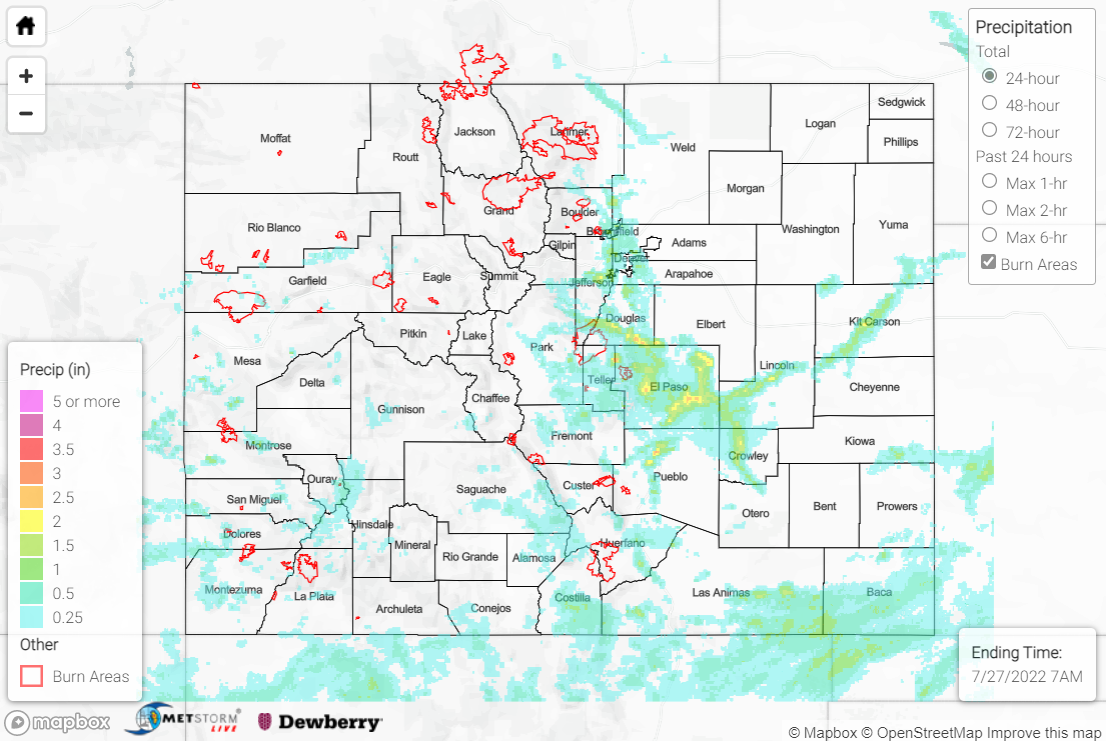
Issue Date: Wednesday, July 27th, 2022
Issue Time: 11:30 AM MDT
Summary:
Tuesday saw extremely active weather across the state, with tornadoes, flooding, hail, and high winds. Showers and storms formed over the high terrain by early afternoon, with the most intense convection developing over the southern Front Range and its foothills and building south-southeastward. A cool front tracking slowly southward across eastern Colorado provided surface convergence for convective initiation, while diurnal heating and orographic ascent also helped storms to build. The heaviest rainfall occurred east of the Divide, along the I-25 corridor from Denver southward to Pueblo and then eastward across the Palmer Ridge and into Kit-Carson County.
Four Flood Advisories were issued for the greater Denver metropolitan area where 1-2” of rain was observed. Video posted to Twitter showed flooding on I-25 near the I-70 junction:
Major flooding on I-25 both directions in Denver. 1-2 feet of water in places and multiple stuck/crashed cars #COwx @NWSBoulder pic.twitter.com/7nJePa0PDt
— K y l e . C u t l e r (@K_CuT_Wx) July 27, 2022
Numerous reports of hail up to quarter-size (1.00”) were received southeast of Denver, while a mesonet station recorded a 63-mph thunderstorm wind gust. The public reported large tree limbs down and power poles broken. Two more Flood Advisories were also issued for southern Douglas and Jefferson Counties, but no flooding was reported. Notable rainfall observations in the Denver area include:
• 1.76” east of Highlands Ranch
• 1.75” near Centennial
• 1.73” east of Lakewood
• 1.61” near Broomfield
Further south along I-25, the Colorado Springs area experienced significant flooding, with QPE estimates of up to 2.5” of rain. Multiple Flash Flood Warnings, Flood Warnings, and Flood Advisories were issued for eastern Teller and western El Paso Counties. Cars were reported stuck in the road, with street and curbside flooding near the Colorado Springs Airport.
Flooded car, near Fargo’s Pizza, off Tia Juana in Colorado Springs — (lots of calls into dispatch after deluge of rain)@KRDONC13 pic.twitter.com/yVSeB2WBB9
— Heather Skold KRDO (@HeatherSkold13) July 27, 2022
One of the Flood Advisories was issued for Fountain Creek, with the creek cresting overnight just below flood stage. Numerous creeks and streams along the I-25 corridor experienced significant rises with yesterday’s rainfall.
East of Colorado Springs across eastern El Paso County, two Flash Flood Warnings were issued. The public reported significant flooding north of Truckton, along with a road washed out northeast of Calhan. Notable rainfall observations in the Colorado Springs area include:
• 3.02” east-southeast of Larkspur
• 2.13” near Fort Carson (0.61” fell in just 10 minutes, which has an estimated ARI of just under 10 years)
• 1.89” north of Woodland Park
Continuing south along I-25, the Pueblo metropolitan area also saw significant rainfall, with QPE estimates of up to 3” of rainfall north of the city. Flash Flood Warnings and Flood Warnings were issued, with numerous reports of stranded/submerged cars and streets closed due to high water. A NWS employee reported large tree limbs down, and a 57-mph gust was measured in the area. Notable rainfall observations in the Pueblo area include 0.94”, 0.92”, and 0.89” all near Pueblo West.
Our KRDO crew in the field captured this video of flooding near N. Platteville Blvd. and E. Auburn Ave. in Pueblo County.
Share your story videos/photos here: https://t.co/Ws0t7nld66 pic.twitter.com/q5qJThIKOZ— KRDO NewsChannel 13 (@KRDONC13) July 27, 2022
Across south-central and southwestern portions of the state, heavy rainfall was also observed. Two Flood Advisories were issued for western Montrose County on the Southwest Slope, but no flooding was reported. A Flash Flood Warning and Flood Warning were issued for south-central Costilla County, with emergency management reporting flooding along County Road R near San Luis. A mudslide occurred along Highway 550 on Red Mountain Pass near Ironton, although no Flood Warnings or Advisories were issued for this area. Rain gauge coverage is sparse but notable rainfall observations include 0.97” and 0.74” in the western San Juans, as well as 0.93” west of Trinidad.
CDOT maintenance crews have opened US 550 Red Mountain Pass after a significant mudslide Tuesday afternoon. Several pieces of heavy equipment were used to clear 3 ft. of mud and debris including dead trees, limbs, and boulders. pic.twitter.com/YrVpXQt1Va
— Jayson Luber (@Denver7Traffic) July 27, 2022
Lastly, numerous tornado reports were received in Kit-Carson County along I-70 near Seibert, Vona, and Stratton. Damage and debris were reported, and the Goodland WFO confirmed an EF-0 tornado with estimated wind speeds of 65-85 mph. 1.25” hail was reported in the area, while 0.74” and 0.73” of rainfall was measured in Seibert and Stratton, respectively.
Great tornado video today from George Prather north of I-70 in Colorado. @DenverChannel pic.twitter.com/6cWNXiV6MZ
— Mike Collier (@MikeCollierWX) July 27, 2022
If you observe flooding in your area, remember to use the “Report a Flood” page to make any flood reports when you can safely do so. For precipitation estimates in our area, check out the map below.

