SPM 05-21-2019: Spring Storm Brings Snow to the Urban Corridor

Issue Date: Tuesday, May 21st, 2019
Issue Time: 9:20AM MDT

Summary:

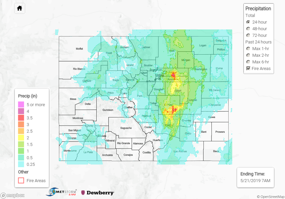
A very strong trough and low moved into southeast Colorado yesterday. Temperatures dropped off significantly with this storm, so winter wasn’t quite over yet. Snow was being reported in Parker during the late morning. With the changeover occurring so early, higher 24-hour accumulations were expected over the Palmer Ridge. The changeover occurred by early evening over the Urban Corridor, so everyone woke up to some snow this morning. To see snow totals from yesterday, check out a map here: Snow Totals for 5/20-5/21/2019.

A few stronger storms were able to form over the Southeast Plains where more favorable dynamics were present by early morning. However, they remained below severe threat criteria with only small hail reports. A gust of 59 mph was recorded at La Junta Airport with radar indicating up to 4 inches of rain falling in the area. Max 1-hr rain rates remained below 1.5 inches over lush vegetation, so flooding was not an issue. The highest 24-hour totals were along a north-south line from central Adams County to Pueblo County. There was also heavy snowfall over the mountains with the highway being shut down for bit near the tunnel. Over western Colorado, totals were estimated up to 1 inch over the mountains, which fell as snow. There was a brief funnel reported near Glad Park in Mesa County associated with a storm in the area, which goes to show how mountains produce their own unique circulations.

To see precipitation totals from Monday over your area, scroll down to the State Precipitation Map below.

Click Here For Map Overview

The map below shows radar-estimated, rainfall gage-adjusted Quantitative Precipitation Estimates (QPE) across Colorado. The map is updated daily during the operational season (May 1 – Sep 30) by 11AM. The following six layers are currently available: 24-hour, 48-hour and 72-hour total precipitation, as well as maximum 1-hour, 2-hour and 6-hour precipitation over the past 24 hour period (to estimate where flash flooding may have occurred). The 24-hour, 48-hour and 72-hour total precipitation contain bias corrections that are not disaggregated into the hourly estimates, so there will likely be some differences. The accumulation ending time is 7AM of the date shown in the bottom right corner. Also shown optionally are vulnerable fire burn areas (post 2012), which are updated throughout the season to include new, vulnerable burn areas. The home button in the top left corner resets the map to the original zoom.

SPM 05-20-2019: Cool Temperatures and some Drying between Systems to Round out the Weekend

Issue Date: Monday, May 20th, 2019
Issue Time: 10:15AM MDT

Summary:

As the upper level low approached from the west, southwest flow pulled some higher moisture into the southern tier of the state. Generally, showers and weak thunderstorms were confined to the higher terrains with some spill over activity into the adjacent valleys for western Colorado. Not a lot of rainfall for the southeast quadrant of the state due to downsloping effects. With a surface low over the eastern plains, moisture and upslope flow combined for some light showers over the Front Range. As the storms moved into the adjacent plains, totals quickly began to drop off. Overall, temperatures remained cool once again, although highs were slightly higher than Saturday.

The highest rainfall values Sunday were reported over the Front Range, Roan Plateau and San Juan Mountains where radar indicates just under 0.5 inches fell. A SNOTEL site in Niwot recorded 0.6 inches. A couple nocturnal thunderstorms over the far eastern plains produced 0.4 inches. With limited low level moisture, storms yesterday did not produce flooding.

To see precipitation totals from Sunday over your neighborhood, scroll down to the State Precipitation Map below.

Click Here For Map Overview

The map below shows radar-estimated, rainfall gage-adjusted Quantitative Precipitation Estimates (QPE) across Colorado. The map is updated daily during the operational season (May 1 – Sep 30) by 11AM. The following six layers are currently available: 24-hour, 48-hour and 72-hour total precipitation, as well as maximum 1-hour, 2-hour and 6-hour precipitation over the past 24 hour period (to estimate where flash flooding may have occurred). The 24-hour, 48-hour and 72-hour total precipitation contain bias corrections that are not disaggregated into the hourly estimates, so there will likely be some differences. The accumulation ending time is 7AM of the date shown in the bottom right corner. Also shown optionally are vulnerable fire burn areas (post 2012), which are updated throughout the season to include new, vulnerable burn areas. The home button in the top left corner resets the map to the original zoom.

SPM 05-19-2019: Widespread Showers and a Few Embedded Thunderstorms

Issue Date: Sunday, May 19th, 2019
Issue Time: 9:10 AM MDT

Summary:

An upper-level trough traversing the Central Rockies yesterday was the culprit behind an unsettled Saturday across Colorado. The trough shifted broad-scale lift overhead, providing enough forcing to produce scattered rain and snow showers over the High Country, and widespread showers (with a few embedded thunderstorms) east of the mountains. Most of the precipitation was light, owing to generally meager moisture. However, across the eastern plains where activity persisted for a few hours, thunderstorms were able to draw on moist outflow from previous showers/storms to produce periods of moderate rainfall. Generally speaking, the first showers of the day began between around 10 AM, with most activity coming to an end by 8 PM; a few showers lingered over the northern High Country until 10 PM.

No flash flooding was reported yesterday. For a look at precipitation estimates in your area, please see the State Precipitation Map below.

Click Here For Map Overview

The map below shows radar-estimated, rainfall gage-adjusted Quantitative Precipitation Estimates (QPE) across Colorado. The map is updated daily during the operational season (May 1 – Sep 30) by 11AM. The following six layers are currently available: 24-hour, 48-hour and 72-hour total precipitation, as well as maximum 1-hour, 2-hour and 6-hour precipitation over the past 24 hour period (to estimate where flash flooding may have occurred). The 24-hour, 48-hour and 72-hour total precipitation contain bias corrections that are not disaggregated into the hourly estimates, so there will likely be some differences. The accumulation ending time is 7AM of the date shown in the bottom right corner. Also shown optionally are vulnerable fire burn areas (post 2012), which are updated throughout the season to include new, vulnerable burn areas. The home button in the top left corner resets the map to the original zoom.

SPM 05-18-2019: Scattered Showers and Thunderstorms, A Few Severe Over Northeast Colorado

Issue Date: Saturday, May 18th, 2019
Issue Time: 9:10 AM MDT

Summary:

An upper-level trough that was centered over the Great Basin on Thursday pushed eastward and moved overtop of Colorado yesterday and provided large-scale lift for the development of showers and thunderstorms. Most of the activity occurred over the High Country and Northeast Colorado, while the Southeast Plains were more-or-less shut out thanks to a lack of surface moisture (dewpoints were in the 20s and 30s). The strongest storms of the day occurred over the Urban Corridor and Northeast Plains north of I-70, producing hail, strong winds (one severe gust of 66 mph reported in Briggsdale), and periods of moderate rainfall. The following severe hail reports were submitted to the National Weather Service:

2.75 inch hail: Sedgwick (Sedgwick County)
2.50 inch hail: 4 miles E of Merino (Logan County)
2.00 inch hail: Sedgwick (Sedgwick County)
1.75 inch hail: Crook (Logan County), Sterling (Logan County)
1.50 inch hail: 1 mile ENE of Sterling (Logan County), Sedgwick (Sedgwick County)
1.25 inch hail: 8 miles W of Greeley (Weld County)
1.00 inch hail: Frederick (Weld County), 12 miles NNE Pawnee Buttes (Weld County), 2 miles N of Dailey (Logan County), 9 miles NW of New Raymer (Weld County), 9 miles SW of Westplains (Weld County)

No flash flooding was reported yesterday. For a look at precipitation estimates in your area, please see the State Precipitation Map below.

Click Here For Map Overview

The map below shows radar-estimated, rainfall gage-adjusted Quantitative Precipitation Estimates (QPE) across Colorado. The map is updated daily during the operational season (May 1 – Sep 30) by 11AM. The following six layers are currently available: 24-hour, 48-hour and 72-hour total precipitation, as well as maximum 1-hour, 2-hour and 6-hour precipitation over the past 24 hour period (to estimate where flash flooding may have occurred). The 24-hour, 48-hour and 72-hour total precipitation contain bias corrections that are not disaggregated into the hourly estimates, so there will likely be some differences. The accumulation ending time is 7AM of the date shown in the bottom right corner. Also shown optionally are vulnerable fire burn areas (post 2012), which are updated throughout the season to include new, vulnerable burn areas. The home button in the top left corner resets the map to the original zoom.