SPM 07-04-2019: Isolated Afternoon Storms with a Riverine Flood Threat

Issue Date: Thursday, July 4th, 2019
Issue Time: 9:30AM MDT

Summary:

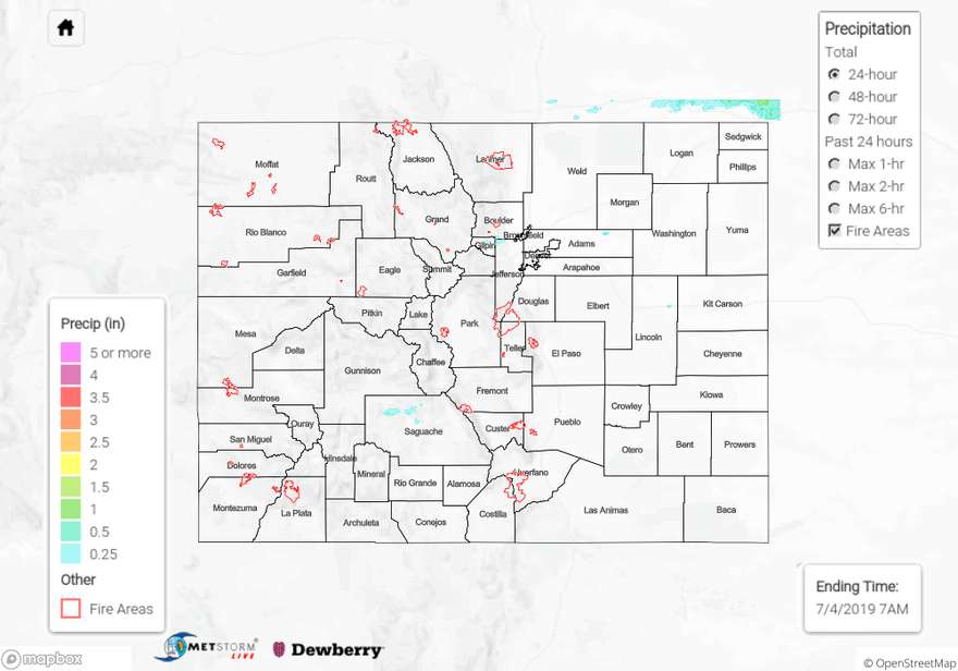
Southwest flow ushered in a very dry air mass over the state yesterday. Without much instability or lift, afternoon showers and weak thunderstorms were limited in coverage. Without the midlevel energy, storms were only initiated by weak upslope flow favoring the Continental Divide and eastern mountains for storm development. Storms over the high country produced rainfall totals up to 0.25 inches with an ALERT gage capturing 0.20 inches of rain at the gage near Golden Gate Canyon State Park. Totals over Saguache County were estimated up to 0.25 inches by radar. The Apishapa SNOTEL gage in the Southeast Mountains recorded 0.3 inches for the day. As storms tracked into the eastern plains, they didn’t gain much efficiency in rainfall production as it was rather late in the day and better moisture was further east. A CoCoRaHS station in the Black Forest area recorded 0.19 inches for the day. Dense fog was present over the far Northeast Plains this morning thanks to a passing front moistening the lower levels of the atmosphere. As anticipated, flooding was not reported.

Although flows on several rivers and creeks were elevated yesterday, with NWS Flood Warnings issued for the Eagle River near Gypsum and the Arkansas River near Avondale, there was no riverine flooding reports as of this morning. However, it is likely there was ongoing lowland flooding in problematic spots. The Avondale gage remains at the Minor flood stage this morning with other stations in Action stage: AHPS gages

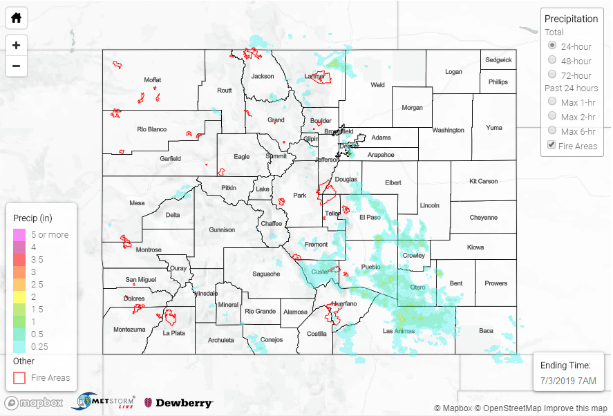
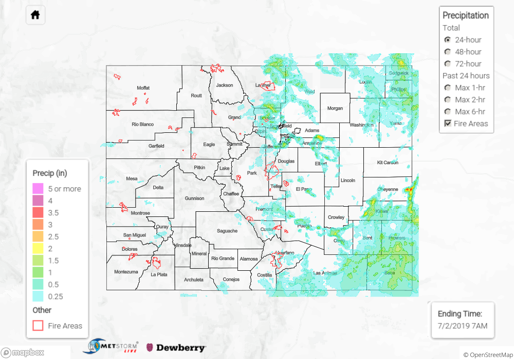
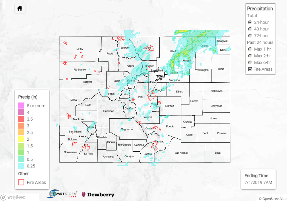
To see estimated precipitation totals over your neighborhood yesterday, scroll down to the State Precipitation Map below.

Click Here For Map Overview

The map below shows radar-estimated, rainfall gage-adjusted Quantitative Precipitation Estimates (QPE) across Colorado. The map is updated daily during the operational season (May 1 – Sep 30) by 11AM. The following six layers are currently available: 24-hour, 48-hour and 72-hour total precipitation, as well as maximum 1-hour, 2-hour and 6-hour precipitation over the past 24 hour period (to estimate where flash flooding may have occurred). The 24-hour, 48-hour and 72-hour total precipitation contain bias corrections that are not disaggregated into the hourly estimates, so there will likely be some differences. The accumulation ending time is 7AM of the date shown in the bottom right corner. Also shown optionally are vulnerable fire burn areas (post 2012), which are updated throughout the season to include new, vulnerable burn areas. The home button in the top left corner resets the map to the original zoom.

SPM 07-03-2019: Heavy Rainfall over the Raton Ridge and western Southeast Plains

Issue date: Wednesday, July 3, 2019
Issue time: 10:55 AM MDT

Summary:

Upslope flow was the primary source yesterday that lead to scattered showers over the high country, Urban Corridor, and Southeastern Plains.  Surface moisture was widespread once again, with maximum relative humidity greater than 80% for the western two thirds of the state.  Surface flow from the west kept things dry over the western border, as arid air from Utah and Arizona made its way in behind a weak shortwave in Utah.  Upslope flow off of the Cheyenne Ridge lead to an isolated report of 0.79 inches from Buckeye RAWS station north of Wellington in Larimer County.  The southern Urban Corridor had some very heavy rainfall rates during the afternoon, with an ALERT gage in Douglas County measuring 0.63 inches in 15 minutes. The 1 hour total was just under 1 inch at this gage. Radar indicates up to 1 inch fell with the storms in the area.

Storms moved east off of the Raton Ridge and Southwest Mountains and made their way to the Arkansas River Basin by early last night. CoCoRaHS stations reported 0.35 and 0.28 inches at Pueblo and La Junta Airports, respectively.  Radar derived rainfall estimates were just over 1.5 inches in Las Animas, Bent, El Paso and Crowley Counties. This makes sense as higher moisture was present over the area as well as slower steering winds, which helped increase the rainfall efficiency of storms.  There were two Flood Warnings issued for the Spring Creek and Junkin burn areas where radar estimated between 0.25 and 0.50 inches of rain fell. As of this morning, there was no flooding reported.

Gages will remain in Action stage throughout the day along the Arkansas, Eagle and Rio Grande Rivers. There are Flood Warnings for the Arkansas and Eagle River at Gypsum. The Blue River below the Dillon Reservoir rose into Action stage yesterday morning due to dam releases.  The Conejos River in Conejos County had reports of minor flooding in low lying areas throughout the county. Please see today’s FTB for the latest on the high flows.

To see estimated precipitation totals over your area on Tuesday, scroll down to the State Precipitation Map below.

Click Here For Map Overview

The map below shows radar-estimated, rainfall gage-adjusted Quantitative Precipitation Estimates (QPE) across Colorado. The map is updated daily during the operational season (May 1 – Sep 30) by 11AM. The following six layers are currently available: 24-hour, 48-hour and 72-hour total precipitation, as well as maximum 1-hour, 2-hour and 6-hour precipitation over the past 24 hour period (to estimate where flash flooding may have occurred). The 24-hour, 48-hour and 72-hour total precipitation contain bias corrections that are not disaggregated into the hourly estimates, so there will likely be some differences. The accumulation ending time is 7AM of the date shown in the bottom right corner. Also shown optionally are vulnerable fire burn areas (post 2012), which are updated throughout the season to include new, vulnerable burn areas. The home button in the top left corner resets the map to the original zoom.

SPM 07-02-2019: Heavy Rainfall, Flash Flooding and Severe Storms

Issue date: Tuesday, July 2, 2019
Issue Time: 12:00 PM MDT

Summary:

Heavy rainfall along the Front Range, Urban Corridor, Northeast and Southeast plains occurred yesterday as a shortwave passed over the state.  Ample surface moisture and upslope flow initiated severe thunderstorms over the eastern areas of the high country midday. A surface cold front helped to initiate storms in the eastern plains later in the afternoon.  Radar derived rainfall was up to two inches in Kiowa and Cheyenne Counties.  There were multiple reports of flash flooding to the NWS near the Spring Creek burn scar, with one report of waters 3 to 4 feet deep over county road 443.  In Left Hand Canyon in Boulder County near Gold Hill, mud and rocks washed onto the road after reported rainfall of 2.13 inches.  Heavy rainfall associated with slow moving, severe thunderstorms was reported all along the Front Range and Urban Corridor.  Hail of 1.25 inches was measured in northern Weld Country and hail up to 1 inch in Arapahoe County near Aurora.

Rivers remain high throughout the high country due to snowmelt and rainfall over the last three days.  Flows along the Arkansas at Avondale reached Minor flood stage yesterday due to releases from the Pueblo Dam and rainfall over the area.  The gage along the Eagle River near Gypsum also reached Minor flooding yesterday and was only 0.01 inch from breaking the gage height record. Reports from Conejos County within the SLV is still experiencing high water along the Conejos River with flooding at various locations across the county. Terrace and Platoro Reservoirs are also running high, so there will likely be releases, which would cause flooding to already swollen rivers in the area. For local river information that is updated throughout the day, please visit the website of your local NWS office (Boulder, Pueblo, Grand Junction) or track the AHPS gages in your area.

To see estimated precipitation totals over your area on Monday, scroll down to the State Precipitation Map below.

Click Here For Map Overview

The map below shows radar-estimated, rainfall gage-adjusted Quantitative Precipitation Estimates (QPE) across Colorado. The map is updated daily during the operational season (May 1 – Sep 30) by 11AM. The following six layers are currently available: 24-hour, 48-hour and 72-hour total precipitation, as well as maximum 1-hour, 2-hour and 6-hour precipitation over the past 24 hour period (to estimate where flash flooding may have occurred). The 24-hour, 48-hour and 72-hour total precipitation contain bias corrections that are not disaggregated into the hourly estimates, so there will likely be some differences. The accumulation ending time is 7AM of the date shown in the bottom right corner. Also shown optionally are vulnerable fire burn areas (post 2012), which are updated throughout the season to include new, vulnerable burn areas. The home button in the top left corner resets the map to the original zoom.

SPM 07-01-2019: Heavy Rainfall for the Mountains and Northeast Plains

Issue Date: Monday, July 1st, 2019
Issue Time: 9:45AM MDT

Summary:

High pressure continued to the main factor driving weather over Colorado yesterday. Therefore, hot temperatures were present before afternoon storms and cloud cover helped cool things. Moisture associated with Alvin moved over the southwest corner of the state, which allowed for multiple rounds of rain showers and weak thunderstorms beginning around 2PM. More widespread coverage of thunderstorms occurred over the eastern mountains due to higher low level moisture. Storms were mostly confined to the higher terrains with additional activity over the Northeast Plains and Urban Corridor. Most storms came to an end a couple hours after sundown, but some light showers continued over the Northeast Plains through 3AM.

As far as rainfall amount, 2-3 hour totals over the Front Range were generally estimated by radar to around 0.6 inches in the storm centers. There was a storm report of 1.06 inches of rain with pea sized hail in Leadville, which was the highest report of the day for a single storm over the mountains. Three CoCoRaHS locations in Vail recorded around 0.85 inches for the day. In Tabernash, a CoCoRaHS station recorded a 1.25 inch total for two storms that tracked through the area. Over the San Juan Mountains in La Plata County where moisture was a bit lower, a SNOTEL station recorded 0.5 inches. Storms that formed over the Urban Corridor and Northwest Plains produced some gusty winds and large hail (up to 1.75 inches). A downburst from a severe thunderstorm near Prospect (Weld County) knocked down a fence along with several branches. Radar rainfall estimates in the area were up to 2 inches.

As far as NWS Flash Flood Warnings, a warning was issued for the Spring Creek burn area at 4:30PM, and a Flood Advisory was issued for a storm around the same time that popped up between Pueblo and Colorado Springs. As of this morning, there were no flooding reports for yesterday.

To see estimated precipitation totals over your area on Sunday, scroll down to the State Precipitation Map below.

Click Here For Map Overview

The map below shows radar-estimated, rainfall gage-adjusted Quantitative Precipitation Estimates (QPE) across Colorado. The map is updated daily during the operational season (May 1 – Sep 30) by 11AM. The following six layers are currently available: 24-hour, 48-hour and 72-hour total precipitation, as well as maximum 1-hour, 2-hour and 6-hour precipitation over the past 24 hour period (to estimate where flash flooding may have occurred). The 24-hour, 48-hour and 72-hour total precipitation contain bias corrections that are not disaggregated into the hourly estimates, so there will likely be some differences. The accumulation ending time is 7AM of the date shown in the bottom right corner. Also shown optionally are vulnerable fire burn areas (post 2012), which are updated throughout the season to include new, vulnerable burn areas. The home button in the top left corner resets the map to the original zoom.