FTO 06-04-2015: Two Events Unfolding in the Next 15 Days

Issue Date: 6/04/2015
Issue Time: 1:35 PM

Threat_Timeline

The transition to the summer season is well underway and, here in Colorado, it marks a particularly challenging time for forecasters. As low-pressure systems become fewer and further in between as compared to winter and spring, much of the forecasting reduces to a smaller, more individualized scale. The hot southwest United States ridge becomes a semi-permanent feature, with smaller disturbances attempting to break into that ridge, and only those disturbances, on average, will bring about an organized flood threat. During this 15 day period, there are two such organized threats in which this FTO will be focused upon.

  • Event #1: Friday (06-05-2015) through Tuesday (06-09-2015)
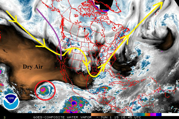
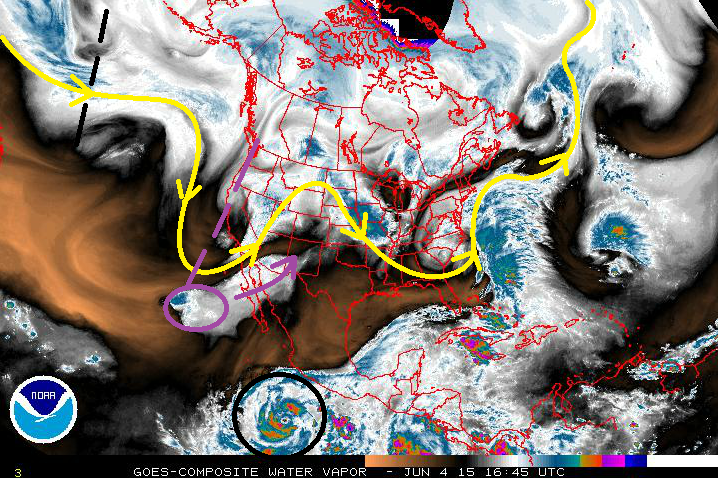
    • The upper-level trough (marked by the dashed purple line) will continue to deepen across the West Coast tonight and into tomorrow, increasing southwesterly flow across the state. Hurricane Andres, which has now become Tropical Storm Andres (circled in purple), was the primary concern of Monday’s FTO to bring the threat of deep moisture and heavy rain during this period. The trough has, in fact, already been drawing the tropical moisture north-northeastward (purple arrow), and will bring it into Colorado starting on Friday.
  • Event #2: Thursday (06-11-2015) through Tuesday (06-16-2015)
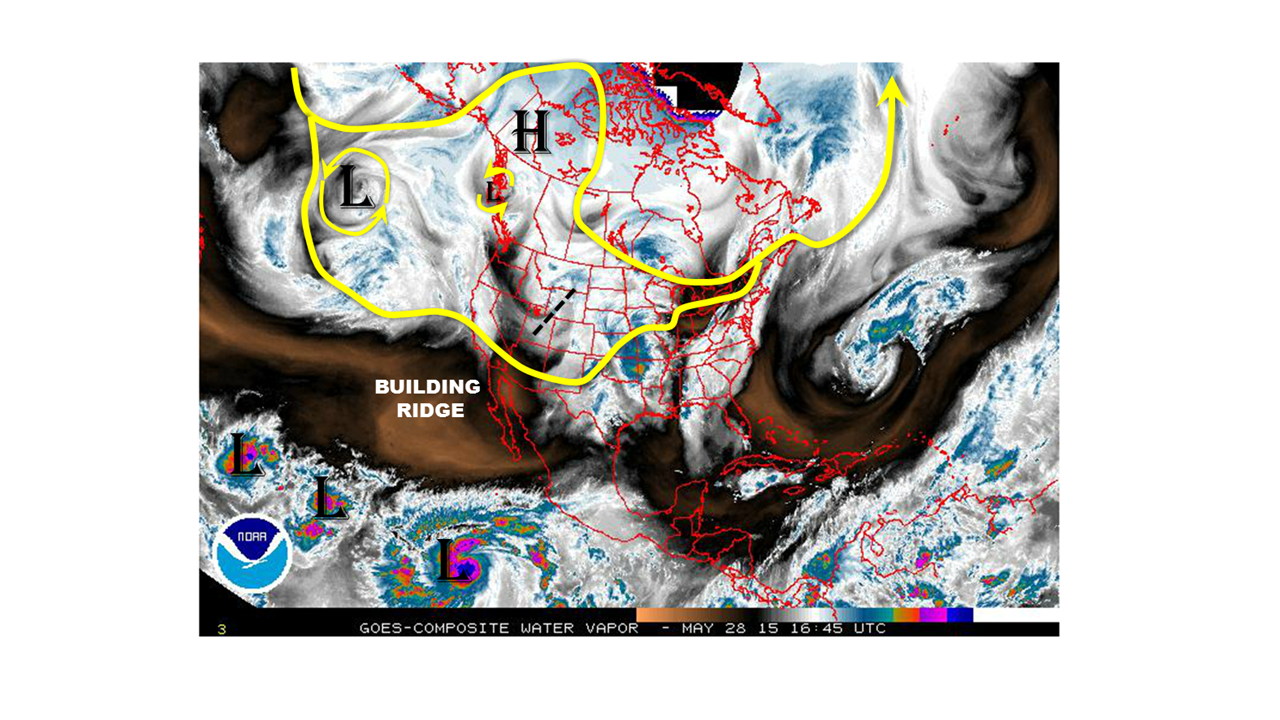
    • The same sort of scenario as Event #1 will play out as Event #2. There are a few differences, though, and those are important to consider going forward. While the evolution of Event #1 was fairly easy to discern by the overall pattern, Event #2 is a bit more “hidden,” so to speak. The upper-level trough (marked by the dashed black line) is not expected to deepen as much as the Event #1 trough. Instead, it appears to be a bit more transient from west to east, as the overall atmospheric flow pattern becomes more zonal. Instead, for this event, all eyes shift towards Hurricane Blanca, circled in black at the bottom of the image. This storm is expected to take a more northward track than Andres, and will look to provide a bigger moisture punch. It will be of utmost importance to monitor Hurricane Blanca and her moisture plume – it holds the key to the threat of heavy rain.

WV_20150604


Event #1: Friday (06-05-2015) through Tuesday (06-09-2015)

Elevated Flood Threat Developing as Tropical Moisture is Pulled into Colorado

The upper-level trough will indeed tap into the tropical moisture from now-Tropical Storm Andres. This will allow precipitable water values to climb to near, or above, an inch statewide, which will be in the 90th percentile for this time of year. That depth of moisture will make showers and thunderstorms efficient rainfall producers, bringing a heavy rain and subsequent flash flooding threat.

It will be important to monitor the locations of fronts and drylines, as well as the tracks of passing mid-level disturbances, to determine where the strongest storms and heaviest rain will develop for each day. The threat of severe storms will exist statewide through at least Saturday. The wettest days of this event will be Friday-Sunday, with moisture drying out from west to east beginning on Sunday evening. By Monday and Tuesday, the upper-level low will be exiting to the east/northeast, and ridging will begin building in behind it for a short period of time.

Legend

Event #2: Thursday (06-11-2015) through Tuesday (06-16-2015)

Elevated Flood Threat on the Horizon, Will Hurricane Blanca be the Next Source of Deep Moisture?

Hurricane Blanca and her eventual track will important to monitor over the coming days. Currently, the forecast calls for Blanca to move more northward than Andres, presenting a deep plume of moisture for Colorado without the aid of a trough digging deep into the Eastern Pacific. Instead, a ridge of high pressure over the central US will aid in bringing the moisture northward as the upper-level trough passes over Nevada, Utah, and then Colorado, before continuing eastward. The wettest days of this period will be Thursday through Saturday, but as Sunday rolls around, high pressure ridging will begin building back overhead, leaving Monday and Tuesday as days working with residual moisture, daytime heating, and not much else.

Legend

FTO 06-01-2015: The Transition to Summer is Underway

Issue Date: 6/1/2015
Issue Time: 1:38 PM

06012015_ThreatTimeline

The transition to the summer season here in Colorado marks a particularly challenging time for forecasters. As low-pressure systems become fewer and further in between as compared to winter and spring, much of the forecasting reduces to a smaller, more individualized scale. The hot southwest United States ridge becomes a semi-permanent feature, with smaller disturbances attempting to break into that ridge. Only those disturbances, on average, will bring about an organized flood threat. During this 15 day period, there is only one such organized threat in which this FTO will be focused upon.

  • Event #1: Thursday (06-04-2015) through Tuesday (06-09-2015)
    • The upper-level trough (marked by the purple line) will deepen across the West Coast, increasing southwesterly flow across the state. While there is a lot of dry air out over the SW United States and nearby Pacific Ocean, one feature will attempt to allow deeper moisture to flow over Colorado. This feature is known as Hurricane Andres, and is circled in red. If, and only if, the upper-level trough can deepen and tap into the tropical moisture associated with Hurricane Andres, then an organized flood threat will develop. If not, dry, mid-level air will be driven over Colorado, reducing the flood threat to an individualized storm basis.

06012015_WV

After the aforementioned upper-level trough washes out, upper-level ridging is forecast to again build back in over Colorado, tapping into the dry air from the southwest. This will bring summer warmth right on schedule. How long this ridging and will last is the million dollar question. Current thinking is that the most likely outcome is the ridging will persist through the end of the period, since there aren’t any notable disturbances coming down the storm track pipe. Be sure check daily on the Flood Threat Bulletin to stay up-to-date with the forecast.

Event #1: Thursday (06-04-2015) through Tuesday (06-09-2015)

Elevated Flood Threat on the Horizon, IF the Tropical Moisture can be Tapped

The big question in this forecast is if the upper-level low can tap into the tropical moisture from Hurricane Andes. If it can, precipitable water values will climb to near an inch statewide, which will be in the 90th percentile for this time of year. That depth of moisture will make showers and thunderstorms efficient rainfall producers, bringing a heavy rain and flash flooding threat.

At the same time, a surface low/lee-side trough will develop across eastern Colorado early in the event period, helping to bring in low-level moisture from the Gulf of Mexico and upslope flow. It will be important to monitor the locations of fronts and drylines to determine where the strongest storms and heaviest rain will develop. These features/associated fronts will exit Colorado over the weekend as the whole event winds down on Sunday-Monday-Tuesday.

The precipitation map below depicts the outcome IF THE UPPER-LEVEL LOW CAN TAP INTO THE TROPICAL MOISTURE. If it cannot, then totals will be measurably less.

Legend

FTO 5-28-2015: TRANSITION TO SUMMER UNDERWAY; NO CLEAR FLOOD THREAT

Issue Date: May 28th, 2015
Issue Time: 3:00PM MDT
Valid Time: May 29th through June 12th

threat_timeline_20150528

For Colorado, the transition to summer means lots of hiking and camping, melting snow and hot afternoons with thunderstorms. From the standpoint of weather forecasting, however, summer brings about a challenging season where a given day’s weather can strongly impact the next day’s. This is the conundrum at hand. The next two weeks will see a classic duel between the hot southwest United States “ridge” and disturbances attempting to break into the heart of that ridge. Only such successful disturbances will bring about an organized flood threat. No such threats are apparent through the June 12th end date of this Flood Threat Outlook.

Today’s weather circulation, shown below, is crowded with many players. First off is the disturbance currently traversing across Colorado. This is bringing about several rounds of shower and thunderstorm activity, but the flood threat is limited to the Kansas border where low-level moisture is better. Next, we see the high-pressure ridge over western Canada. This has been establishing a roadblock to disturbances: forcing them to go either north of south of it. In the past two to three weeks disturbances have managed to find a way south of it and into Colorado. However, presently, there is an additional ridge building to its south that will provide a further obstacle in the flow. In fact, it is the development of the southern ridge that will prevent the copious amounts of subtropical moisture found across the eastern Pacific from making it into Colorado (note three active tropical disturbances on water vapor). Finally, we see a large cut-off cyclone in the middle of the Pacific Ocean. Though this feature will take it’s time, it could affect our weather pattern over the next 5-7 days.

watervapor_20150528_smallSo how do we see the next two weeks evolving? The current disturbance will slowly leave the state by late Friday, initiating another round of thunderstorm activity on Friday. Rainfall amounts are expected to stay under one inch, except for very isolated areas. See our Flood Threat Bulletin discussion tomorrow for further details. Beginning on Saturday and lasting through most of next week, Colorado will begin a period of drier and warmer weather. That is not to say that it will not rain: it will, with almost each afternoon resulting in higher elevations showers and weak thunderstorms. However, this will not amount to much rainfall, generally less than half an inch on any given day at any given locale. Furthermore, this stretch of warmer weather will cause a substantial decrease in the state’s remaining snowpack, the status of which is shown below. As the snowpack is already only a fraction of its seasonal maximum, we do not anticipate widespread flooding concerns. However, there may be isolated flooding issues in the South Platte and Arkansas basins due to the recent two to three weeks’ worth of heavy snowfall.

current_SWE

By next weekend and thereafter, our weather will be strongly impact by the fate of the low-pressure system over the Central Pacific. Current guidance and intuition shows a very large spread in possible outcomes. At this time, there is not enough confidence to determine when an “event” could occur, and event if an event occurs, how much rainfall could fall.

Finally, as the tropical Pacific weather appears to be an integral part of this summer’s precipitation outlook over Colorado, we encourage readers to check out our El Nino discussion from Monday’s (5/25) Flood Threat Outlook.

FTO 05-25-2015: WEATHER PATTERN TO FINALLY SIMMER DOWN AND GIVE WAY TO SUMMER HEAT; PLUS, HOW WILL EL NINO IMPACT THE SUMMER RAINS?

Issue Date: 5/25/2015
Issue Time: 12:00PM
Valid period: May 26th through June 9

threat_timeline_20150525

The prolonged stretch of very active weather characterized by cloudy, cool, rainy and snowy conditions appears to be winding down. The water vapor image below shows this morning’s snapshot of the Northern Hemisphere circulation. Much like the past two to three weeks, the overall pattern consisted of a strong extratropical jet over the west Pacific Ocean. The flow associated with the jet then splits into two flows midway across the ocean, resulting in a strong high pressure ridge over western Canada and the famous “cut-off” lows off the California coast and the southwest U.S. It is of course the latter that has been the culprit of consistent wet days across Colorado.

watervapor_20150525

In the near-term, the major change to the above pattern will be two fold. First, a general slow-down in the progression of features. Second, the gradual development of a high-pressure ridge across the southwest U.S resulting in much warmer temperatures over Colorado by next week.

Over the next two weeks, we have identified three events that may impact the flood threat. Only the first event has an Elevated flood threat. The second event is tied to the forecasted snow-melt from much warmer temperatures. The third event is a combination of warmer temperatures plus the potential of tropical moisture impacting the western part of the state. Below is a more detailed description of each event.

NOTE: After we describe the three events below, we provide an El Nino update to get a glimpse at the longer-range summer forecast. In short, think “wet”, but please be sure to check out the full discussion.

The three events that we have identified are:

  • Event #1: Friday (5/29) through Saturday (5/30)
    • An Elevated flood threat east of the Divide
  • Event #2: The following Wednesday (6/3) through Saturday (6/6)
    • Much warmer temperature will result in elevated streamflows over large snowpack areas of the higher terrain. No flood threat is anticipated at this time, but this will be a key feature to watch.
  • Event #3: Next week’s Saturday (6/6) through Sunday (6/7)
    • A tropical system is expected to come up the Central American coast and possibly bring moisture west of the Divide. No flood threat is currently anticipated, but the tropical feature will need to be closely monitored.

EVENT 1: Friday (5/29) through Saturday (5/30)

An Elevated flood threat for most of eastern Colorado

A stationary front is expected to move across eastern Colorado later this week. This will combine with an upper-level disturbance that is currently positioned over the northwest U.S. coast (see water vapor image above) to result in heavy rainfall. The best estimate of the highest rainfall totals, in the 1.5 to 2.0 inch range, is expected in east-central Colorado, but this will be substantially refined in the next Flood Threat Outlook.

Legend

EVENT 2: Wednesday (6/3) through Saturday (6/6)

No flood threat is anticipated at this time

The development and intensification of the southwest U.S. high-pressure ridge will result in much warmer temperature by next week. High temperatures may reach the mid-80s to mid-90s in the lowest elevations with 50s and 60s in the highest elevations. Given the recent amount of heavy, wet snowfall across the higher terrain, this will cause significant snow melt. While no flood threat is currently apparent, individual basins will be monitored to assess the amount of snowpack remaining along with forecasted temperatures.

EVENT 3: Saturday (6/6) through Sunday (6/7)

No flood threat is anticipated at this time

A tropical disturbance is forecasted to develop and progress up the Central American coast through the Baja of California by the middle of next week. Once it reaches the Baja, it is unclear if the disturbance will disintegrate and release substantial moisture into the southwest U.S. or continue off to the west and keep the moisture for itself. The former will result in a flood threat west of the Divide, while the latter will not impact the Colorado much. The next two Flood Threat Outlooks should have a much better grasp of this feature.

EL NINO UPDATE

As a final note in today’s Flood Threat Outlook, we present a brief overview of what the ongoing El Nino may bring for Colorado. There is mounting evidence that the current weak El Nino will continue and likely intensify as we head into summer. So what does that imply for Colorado precipitation?

The first map shows the current Sea Surface Temperature anomalies (source: NOAA). Note the warm patch of ocean over the equator in the Pacific Ocean; these conditions are referred to as El Nino. These surface anomalies, up to 3 degrees Celsius are also accompanied by sub-surface anomalies of up to 5 degrees Celsius implying a very deep “bank” of warm ocean water to draw from.

sst_anomOne interesting question to pose is: historically, how do warm temperatures in the region outlined by the box in the map above relate to Colorado precipitation? The following map, derived from NOAA’s Earth System Research Laboratory climate page, shows the correlation between ocean temperatures in the equatorial Pacific with precipitation across the U.S over the June – August period. Impressively, a large “bullseye” appears east of the Continental Divide over Colorado. This implies that El Nino conditions tend to favor above average precipitation over most of Colorado, but especially east of the Divide.

ENSO_corrSo what about longer-range forecasts? The Climate Forecast System, operated by the National Centers for Environmental Prediction, provides 9-month forecasts across the world. Below is a map showing the expected precipitation anomaly over the upcoming June-August period. The key word is: wet! It is also interesting how the model forecast is similar to what we have historically observed shown in the map above.

cfs_forecastNote that anomaly refers to precipitation in relation to average. Just for reference, Colorado averages 2-4 inches of precipitation per month over that time period.

While no correlation or forecast is perfect, when we see key data line up, it allows us to build confidence in the upcoming summer forecast. It will be interesting to see how it evolves!