Issue Date: 6/04/2015
Issue Time: 1:35 PM
The transition to the summer season is well underway and, here in Colorado, it marks a particularly challenging time for forecasters. As low-pressure systems become fewer and further in between as compared to winter and spring, much of the forecasting reduces to a smaller, more individualized scale. The hot southwest United States ridge becomes a semi-permanent feature, with smaller disturbances attempting to break into that ridge, and only those disturbances, on average, will bring about an organized flood threat. During this 15 day period, there are two such organized threats in which this FTO will be focused upon.
- Event #1: Friday (06-05-2015) through Tuesday (06-09-2015)
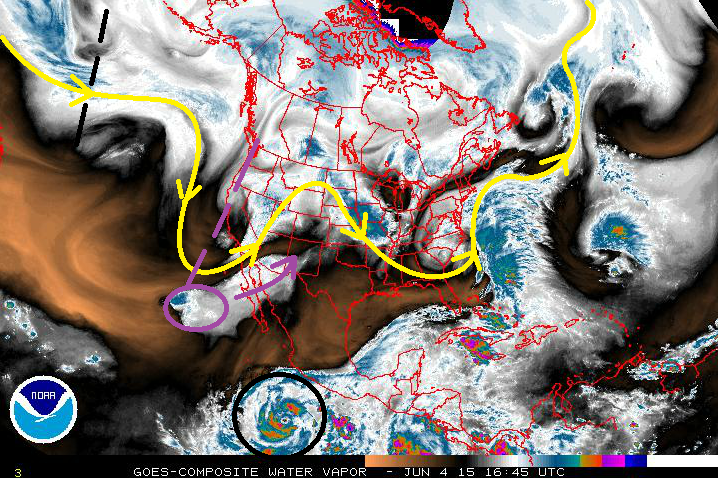
- The upper-level trough (marked by the dashed purple line) will continue to deepen across the West Coast tonight and into tomorrow, increasing southwesterly flow across the state. Hurricane Andres, which has now become Tropical Storm Andres (circled in purple), was the primary concern of Monday’s FTO to bring the threat of deep moisture and heavy rain during this period. The trough has, in fact, already been drawing the tropical moisture north-northeastward (purple arrow), and will bring it into Colorado starting on Friday.
- Event #2: Thursday (06-11-2015) through Tuesday (06-16-2015)
- The same sort of scenario as Event #1 will play out as Event #2. There are a few differences, though, and those are important to consider going forward. While the evolution of Event #1 was fairly easy to discern by the overall pattern, Event #2 is a bit more “hidden,” so to speak. The upper-level trough (marked by the dashed black line) is not expected to deepen as much as the Event #1 trough. Instead, it appears to be a bit more transient from west to east, as the overall atmospheric flow pattern becomes more zonal. Instead, for this event, all eyes shift towards Hurricane Blanca, circled in black at the bottom of the image. This storm is expected to take a more northward track than Andres, and will look to provide a bigger moisture punch. It will be of utmost importance to monitor Hurricane Blanca and her moisture plume – it holds the key to the threat of heavy rain.
Event #1: Friday (06-05-2015) through Tuesday (06-09-2015)
Elevated Flood Threat Developing as Tropical Moisture is Pulled into Colorado
The upper-level trough will indeed tap into the tropical moisture from now-Tropical Storm Andres. This will allow precipitable water values to climb to near, or above, an inch statewide, which will be in the 90th percentile for this time of year. That depth of moisture will make showers and thunderstorms efficient rainfall producers, bringing a heavy rain and subsequent flash flooding threat.
It will be important to monitor the locations of fronts and drylines, as well as the tracks of passing mid-level disturbances, to determine where the strongest storms and heaviest rain will develop for each day. The threat of severe storms will exist statewide through at least Saturday. The wettest days of this event will be Friday-Sunday, with moisture drying out from west to east beginning on Sunday evening. By Monday and Tuesday, the upper-level low will be exiting to the east/northeast, and ridging will begin building in behind it for a short period of time.
Event #2: Thursday (06-11-2015) through Tuesday (06-16-2015)
Elevated Flood Threat on the Horizon, Will Hurricane Blanca be the Next Source of Deep Moisture?
Hurricane Blanca and her eventual track will important to monitor over the coming days. Currently, the forecast calls for Blanca to move more northward than Andres, presenting a deep plume of moisture for Colorado without the aid of a trough digging deep into the Eastern Pacific. Instead, a ridge of high pressure over the central US will aid in bringing the moisture northward as the upper-level trough passes over Nevada, Utah, and then Colorado, before continuing eastward. The wettest days of this period will be Thursday through Saturday, but as Sunday rolls around, high pressure ridging will begin building back overhead, leaving Monday and Tuesday as days working with residual moisture, daytime heating, and not much else.


