Issue Date: May 28th, 2015
Issue Time: 3:00PM MDT
Valid Time: May 29th through June 12th

For Colorado, the transition to summer means lots of hiking and camping, melting snow and hot afternoons with thunderstorms. From the standpoint of weather forecasting, however, summer brings about a challenging season where a given day’s weather can strongly impact the next day’s. This is the conundrum at hand. The next two weeks will see a classic duel between the hot southwest United States “ridge” and disturbances attempting to break into the heart of that ridge. Only such successful disturbances will bring about an organized flood threat. No such threats are apparent through the June 12th end date of this Flood Threat Outlook.
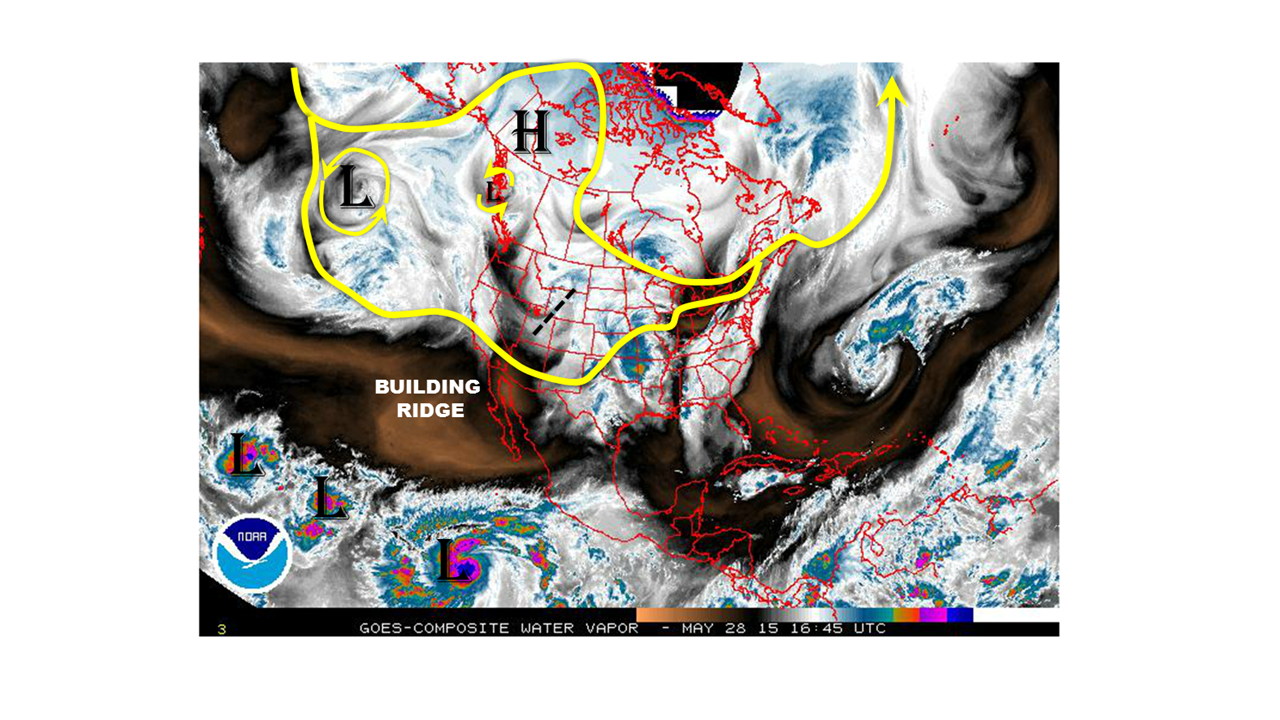
Today’s weather circulation, shown below, is crowded with many players. First off is the disturbance currently traversing across Colorado. This is bringing about several rounds of shower and thunderstorm activity, but the flood threat is limited to the Kansas border where low-level moisture is better. Next, we see the high-pressure ridge over western Canada. This has been establishing a roadblock to disturbances: forcing them to go either north of south of it. In the past two to three weeks disturbances have managed to find a way south of it and into Colorado. However, presently, there is an additional ridge building to its south that will provide a further obstacle in the flow. In fact, it is the development of the southern ridge that will prevent the copious amounts of subtropical moisture found across the eastern Pacific from making it into Colorado (note three active tropical disturbances on water vapor). Finally, we see a large cut-off cyclone in the middle of the Pacific Ocean. Though this feature will take it’s time, it could affect our weather pattern over the next 5-7 days.
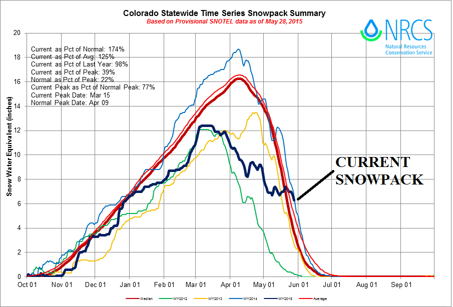
 So how do we see the next two weeks evolving? The current disturbance will slowly leave the state by late Friday, initiating another round of thunderstorm activity on Friday. Rainfall amounts are expected to stay under one inch, except for very isolated areas. See our Flood Threat Bulletin discussion tomorrow for further details. Beginning on Saturday and lasting through most of next week, Colorado will begin a period of drier and warmer weather. That is not to say that it will not rain: it will, with almost each afternoon resulting in higher elevations showers and weak thunderstorms. However, this will not amount to much rainfall, generally less than half an inch on any given day at any given locale. Furthermore, this stretch of warmer weather will cause a substantial decrease in the state’s remaining snowpack, the status of which is shown below. As the snowpack is already only a fraction of its seasonal maximum, we do not anticipate widespread flooding concerns. However, there may be isolated flooding issues in the South Platte and Arkansas basins due to the recent two to three weeks’ worth of heavy snowfall.
By next weekend and thereafter, our weather will be strongly impact by the fate of the low-pressure system over the Central Pacific. Current guidance and intuition shows a very large spread in possible outcomes. At this time, there is not enough confidence to determine when an “event” could occur, and event if an event occurs, how much rainfall could fall.
Finally, as the tropical Pacific weather appears to be an integral part of this summer’s precipitation outlook over Colorado, we encourage readers to check out our El Nino discussion from Monday’s (5/25) Flood Threat Outlook.