Issue Date: 6/1/2015
Issue Time: 1:38 PM

The transition to the summer season here in Colorado marks a particularly challenging time for forecasters. As low-pressure systems become fewer and further in between as compared to winter and spring, much of the forecasting reduces to a smaller, more individualized scale. The hot southwest United States ridge becomes a semi-permanent feature, with smaller disturbances attempting to break into that ridge. Only those disturbances, on average, will bring about an organized flood threat. During this 15 day period, there is only one such organized threat in which this FTO will be focused upon.
- Event #1: Thursday (06-04-2015) through Tuesday (06-09-2015)
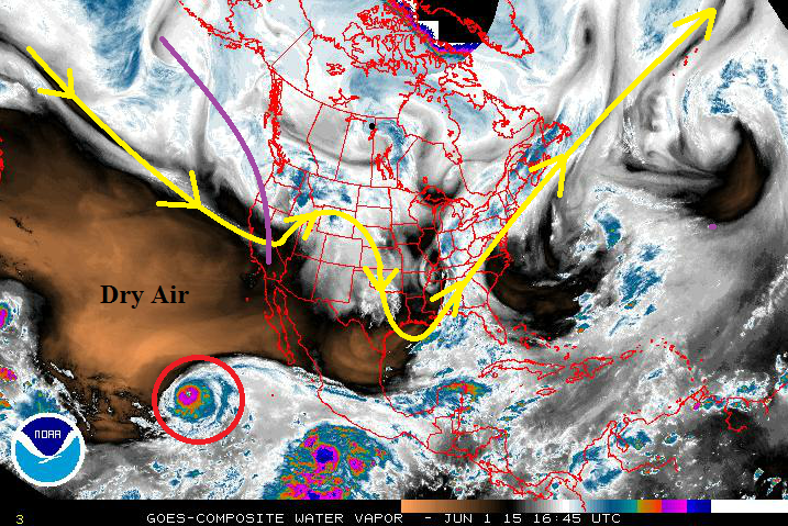
- The upper-level trough (marked by the purple line) will deepen across the West Coast, increasing southwesterly flow across the state. While there is a lot of dry air out over the SW United States and nearby Pacific Ocean, one feature will attempt to allow deeper moisture to flow over Colorado. This feature is known as Hurricane Andres, and is circled in red. If, and only if, the upper-level trough can deepen and tap into the tropical moisture associated with Hurricane Andres, then an organized flood threat will develop. If not, dry, mid-level air will be driven over Colorado, reducing the flood threat to an individualized storm basis.
After the aforementioned upper-level trough washes out, upper-level ridging is forecast to again build back in over Colorado, tapping into the dry air from the southwest. This will bring summer warmth right on schedule. How long this ridging and will last is the million dollar question. Current thinking is that the most likely outcome is the ridging will persist through the end of the period, since there aren’t any notable disturbances coming down the storm track pipe. Be sure check daily on the Flood Threat Bulletin to stay up-to-date with the forecast.
Event #1: Thursday (06-04-2015) through Tuesday (06-09-2015)
Elevated Flood Threat on the Horizon, IF the Tropical Moisture can be Tapped
The big question in this forecast is if the upper-level low can tap into the tropical moisture from Hurricane Andes. If it can, precipitable water values will climb to near an inch statewide, which will be in the 90th percentile for this time of year. That depth of moisture will make showers and thunderstorms efficient rainfall producers, bringing a heavy rain and flash flooding threat.
At the same time, a surface low/lee-side trough will develop across eastern Colorado early in the event period, helping to bring in low-level moisture from the Gulf of Mexico and upslope flow. It will be important to monitor the locations of fronts and drylines to determine where the strongest storms and heaviest rain will develop. These features/associated fronts will exit Colorado over the weekend as the whole event winds down on Sunday-Monday-Tuesday.
The precipitation map below depicts the outcome IF THE UPPER-LEVEL LOW CAN TAP INTO THE TROPICAL MOISTURE. If it cannot, then totals will be measurably less.
