FTO 06-18-2015: Two Upcoming Events, but the Heat is On!

Issue Date: 6/18/2015
Issue Time: 2:06 PM

ThreatTimeline_06182015

Summertime is finally here in Colorado, with temperatures continuing to climb and sunshine begging for outdoor activities. All of this good news makes the FTO easier, and harder, at the same time. But how can things be easier and harder at the same time? Put simply, as long as the southwestern high-pressure ridge is in control, the forecast becomes more of a persistence forecast, with each day seeing a majority of sunshine and warmth. However, this also makes it more difficult on the forecaster to identify in the extended time-frame when disturbances will break down that ridge, how much moisture will be available, and will there be any surface fronts to focus heavy rain/stronger thunderstorms? With all of that said, in this 15-day FTO period, there are two “events” to focus our discussion upon…

  • Event #1: Saturday (06-20-2015) through Monday (06-22-2015)
    • This event was identified in Monday’s FTO as being uncertain with regards to the track of an upper-level disturbance and the amount of moisture available. All of that has come into better focus, and the answers are 1) No upper-level disturbance will be present, and 2) There will not a significant amount of moisture available, either. Two weak surface cool fronts are the culprit.
  • Event #2: Wednesday (06-24-2015) through Sunday (06-28-2015)
    • This event is much like Event #1, with no upper-level disturbance being present to bring about widespread showers and thunderstorms. Instead, this event takes place under the upper-level ridge and is the result of that ridge shifting eastward, bringing moist, southwesterly flow back into Colorado. This event has the looks of a “monsoon-type” moisture surge, but at this time how much moisture will accompany the surge is in question.

WV_20150618


Things to watch after Event #1:
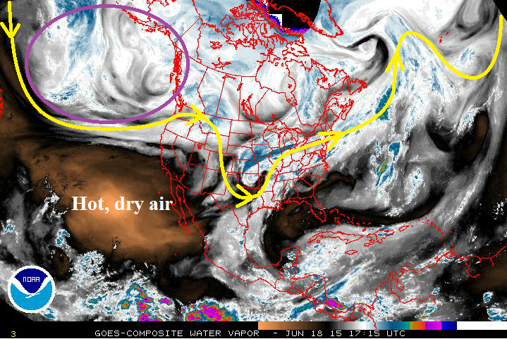
As mentioned above, Event #2 bears watching in the coming days. The amount of moisture that becomes available will be of utmost importance to any possible flood threat development. Aside from that, the HEAT IS ON. This 15-day period will be the hottest of the year so far, with 90-100 F high temperatures likely across the plains. This is all thanks to the high-pressure ridge that is will maintain its presence over the southwestern US, keeping upper-level disturbances and widespread cloud cover away from Colorado.

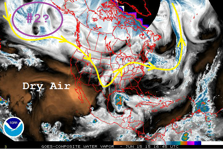
One other note: As time progresses, and we get to Monday’s FTO, the area circled in purple on the water vapor image will be important to watch. At this time, it appears to be a semi-permanent trough feature as the southwestern ridge builds and strengthens. That trough will shoot disturbances to the east every couple of days, but at this time, it appears that those will stay north of Colorado. Should the ridge breakdown more than is currently expected, we will need to keep our eyes on that region.


Saturday (06-20-2015) through Monday (06-22-2015)

No Flood Threat, More Bark than Bite from Isolated Thunderstorms

With no upper-level disturbance present, this event is focused solely on two, weak, surface cool fronts that will drop across Eastern Colorado on Friday and Sunday. These fronts will work beneath warm air aloft, and that warm air aloft will cap off much of the environment. Only isolated storms are expected over the plains, with a few isolated, diurnally-driven thunderstorms over the higher terrain; typical of summertime in Colorado. All precipitation totals look to remain under 0.5 inch.

Legend

Event #2: Wednesday (06-24-2015) through Sunday (06-28-2015)

No Flood Threat Apparent, Details Still Coming Into Focus

With high-pressure ridging aloft building across the southwestern United States, no upper-level disturbance will be present during this “event” period. Instead, the focus for this event will be on a moisture surge from the southwest, thanks to the ridge shifting eastward just a bit during this time. It is uncertain how much moisture will be present, as it is completely dependent on two things: 1) How far eastward will the ridge shift, and 2) Can a surface low developing over the northern United States strengthen enough to pull Gulf moisture northward into Eastern Colorado before it moves eastward towards the Great Lakes?

With the knowledge of the uncertainties in mind, the following precipitation map is subject to change. Be sure to check in on Monday’s FTO for an update to this period.

Legend

FTO 06-15-2015: A Battle Brewing as the Southwest Ridge Fights to Take Hold

Issue Date: 6/15/2015
Issue Time: 2:15 PM

06152015_ThreatTimeline

The clash of two weather regimes will take place over Colorado during this 15-day period. The active weather pattern that has enveloped the state for a few weeks now is finally facing a formidable challenge from the dry “Southwest Ridge.” With the stage set, let’s discuss the upcoming 15-day period…

  • Event #1: Tuesday (06-16-2015) through Thursday (06-18-2015)
    • This event is marked as the clash of the weather regimes, with perhaps the “last hurrah” of the moist, active period. As the dry Southwest Ridge fights to take hold, moisture will lessen as time marches on, but there will remain enough residual moisture for daily rounds of showers and thunderstorms. Wednesday looks to be the most active day of the three, thanks to a passing, surface cool front.
  • Event #2: Saturday (06-20-2015) through Monday (06-22-2015)
    • This event is currently hanging out over the northern Pacific Ocean, and will make its way towards the western United States over the coming days. As it does so, the Southwest Ridge will break down a bit, allowing for cooler temperatures and a few more showers and thunderstorms to return during this period. At this time, the exact track of the disturbance and the amount of moisture that will be present is not clear, and no flood threat is apparent.

06152015_WV

Event #1: Tuesday (06-16-2015) through Thursday (06-18-2015)

Elevated Flood Threat Developing

Event #1 will be marked by lessening moisture as each day passes, thanks to the building high pressure ridge over the region. Wednesday will be the most active day of the three thanks to a passing surface cool front, with scattered strong-to-severe thunderstorms capable of producing heavy rainfall. With snowmelt continuing, and soils remaining saturated, runoff will be enhanced from any thunderstorm. Pay attention to the daily Flood Threat Bulletin for up-to-date information.

Legend

Event #2: Saturday (06-20-2015) through Monday (06-22-2015)

No Flood Threat Apparent

As eluded to above, this event is still coming into focus. With moisture and the specific storm track still uncertain, no precipitation map will be included in this FTO. Look for an update in Thursday’s edition of the Flood Threat Outlook.

FTO 06-11-2015: Two Near-Term Events Followed By Lull As Eyes Turn Back Towards Central Pacific

Issue Date: June 11th, 2015
Issue Time: 3:00PM MDT
Valid Dates: June 12 – June 26

threat_timeline.20150611

By this time of year, the sprawling high pressure normally positioned over the southwest United States begins to gain strength and shut down disturbances as they attempt to cross the west coast. The desert southwest is usually dry, awaiting the monsoonal moisture as the land mass slowly heats up relative to the cooler ocean. How do we know this is not a typical year? A few interesting stats: Phoenix has had 4 rainy days in June, usually a very dry month for them. Los Angeles has also recorded at least a trace of rain on four separate days in June (when they average 0.09 inches for the month). L.A. only had 5 rainy days in all of January, a month during which they average over 3 inches of rain.

Closer to home, the water vapor image, below, shows yet another system that made it on to the west coast, and has crawled over Colorado. This disturbance will mark the first Event of this Outlook, which will feature an Elevated flood threat for Friday 6/12 through Saturday 6/13. Meanwhile, we see no shortage of additional disturbances hanging out over the central Pacific Ocean. At this time, it appears that another event will affect eastern Colorado as the disturbance currently over Alaska will propel a frontal passage on Monday 6/15.

watervapor_20150611After the second event comes through, a lull in activity is expected for most of next week. Colorado should transition to more of a typical pattern with warm days accompanied by daily high-elevation thunderstorms, a few of which will survive as they move off the higher terrain. By the end of next week, a re-organization in the pattern looks to set up a blocking high pressure over western Canada. This is very similar to the pattern we witnessed in May, one that is conducive to rainy weather across our state. At this time, we highlight Event 3 for Friday 6/19 and Saturday 6/20, but with the subtropical ridge shutting off the connection to deeper moisture, we mark this event as one with no apparent flood threat.

Event 1: Friday (6/12) through Saturday (6/13)

An Elevated Flood Threat over the southeast quadrant of the state

The disturbance currently overhead will slowly progress eastward. Meanwhile, a cool front will drape down the east side of the Divide from the north. The cool front will effectively ban most thunderstorm activity north of I-70. But an Elevated flood threat will exist over the Southeast Plains where plenty of moisture will fuel scattered storms with very heavy rain potential.

Legend

Event 2: Monday (6/15)

Another cool front is expected to pass down from Canada setting the stage for a one day upslope event east of the Divide. This event does not look like a very heavy rain producer since instability may be lacking. However, with saturated soils and still some snowpack remaining, please stayed tuned to the Flood Threat Bulletin for updates.

Legend

Event 3: Friday (6/19) through Saturday (6/20)

A reorganization in the weather pattern will again favor the formation of a blocking high off the west coast of Canada. Between this ridge and the typical southwest U.S. “heat” ridge is a favorable avenue for disturbances to enter the western U.S. It appears at this time that such a disturbance may make its way onshore on Thursday and begin to affect Colorado by Friday, into Saturday. However, at this time, we are leaving this event as one with no apparent flood threat since it is not clear how much moisture the system will have to work with.

FTO 06-08-2015: High Flood Threat Developing

Issue Date: 6/8/2015
Issue Time: 1:38 PM

ThreatTimelin_06082015

Even though we have transitioned to the summer months, the hot, southwest United States ridge has had trouble taking hold due to an active Eastern Pacific thanks, in part, to the ongoing El Nino. This has allowed Upper-Level troughs to track across Colorado, with most enjoying an extended stay thanks to a blocking high pressure ridge over the south-central United States. During this next 15 day period, there is one organized threat in which this FTO will be focused upon; this threat is shaping up to be the highest threat of the season thus far.

  • Event #1: Wednesday (06-10-2015) through Monday (06-15-2015)
    • There are three big players for this event noted in the water vapor image below: Upper-level trough (purple line), upper-level cutoff Low (purple “L”), and the moisture remnants of former-Hurricane Blanca. The upper-level trough will phase with the upper-level low over the next day or two, before moving onshore over the West Coast. At the same time, the blocking high over the south-central US will aid the upper-level trough in funneling the moisture from former-Hurricane Blanca into Colorado.

WV_06082015

After Event #1, the forecast gets a bit murky for the remainder of the period. There is very little run-to-run consistency from model guidance, and at this time, observations from satellite imagery do not promote much confidence in the potential timing of the next disturbance. Particularly good attention will need to be paid to the Eastern Pacific off the coast of Mexico, because this region will likely develop the next big moisture plume with its ticket punched for Colorado. Stay tuned for Thursday’s Flood Threat Outlook for our next look into the future.

Event #1: Wednesday (06-10-2015) through Monday (06-15-2015)

High Flood Threat as a Triple Threat of Moisture, Upper-Level Support, and Snowmelt Come Together

With streams already running high as snowmelt picks up steam, the threat of heavy rain from a slow-moving upper-level system with a tropical moisture surge brings a high level of concern. The deep moisture will begin to impede on southwest Colorado Wednesday morning, and increase across the state through Thursday night. This will lead to an uptick on Wednesday afternoon/evening in the coverage of showers and thunderstorms, setting the stage for the rest of this event.

The upper-level system will move into western Colorado on Thursday, bringing support for widespread thunderstorms capable of heavy rain for Thursday afternoon and continuing through the overnight hours. Nighttime flooding can be very serious, and any discussion of heavy rain overnight should be taken as such. The upper-level system will then move very slowly to the east-northeast, hanging out over Colorado through the weekend before exiting the region on Monday. The above average moisture will stick around through the weekend, as well, leaving the threat of heavy rain in the forecast. It will be important to keep an eye on the daily Flood Threat Bulletin throughout this wet period for the most up-to-date and specific information.

Legend