Issue Date: 6/8/2015
Issue Time: 1:38 PM

Even though we have transitioned to the summer months, the hot, southwest United States ridge has had trouble taking hold due to an active Eastern Pacific thanks, in part, to the ongoing El Nino. This has allowed Upper-Level troughs to track across Colorado, with most enjoying an extended stay thanks to a blocking high pressure ridge over the south-central United States. During this next 15 day period, there is one organized threat in which this FTO will be focused upon; this threat is shaping up to be the highest threat of the season thus far.
- Event #1: Wednesday (06-10-2015) through Monday (06-15-2015)
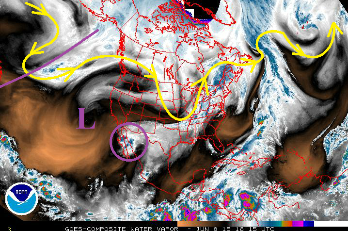
- There are three big players for this event noted in the water vapor image below: Upper-level trough (purple line), upper-level cutoff Low (purple “L”), and the moisture remnants of former-Hurricane Blanca. The upper-level trough will phase with the upper-level low over the next day or two, before moving onshore over the West Coast. At the same time, the blocking high over the south-central US will aid the upper-level trough in funneling the moisture from former-Hurricane Blanca into Colorado.
After Event #1, the forecast gets a bit murky for the remainder of the period. There is very little run-to-run consistency from model guidance, and at this time, observations from satellite imagery do not promote much confidence in the potential timing of the next disturbance. Particularly good attention will need to be paid to the Eastern Pacific off the coast of Mexico, because this region will likely develop the next big moisture plume with its ticket punched for Colorado. Stay tuned for Thursday’s Flood Threat Outlook for our next look into the future.
Event #1: Wednesday (06-10-2015) through Monday (06-15-2015)
High Flood Threat as a Triple Threat of Moisture, Upper-Level Support, and Snowmelt Come Together
With streams already running high as snowmelt picks up steam, the threat of heavy rain from a slow-moving upper-level system with a tropical moisture surge brings a high level of concern. The deep moisture will begin to impede on southwest Colorado Wednesday morning, and increase across the state through Thursday night. This will lead to an uptick on Wednesday afternoon/evening in the coverage of showers and thunderstorms, setting the stage for the rest of this event.
The upper-level system will move into western Colorado on Thursday, bringing support for widespread thunderstorms capable of heavy rain for Thursday afternoon and continuing through the overnight hours. Nighttime flooding can be very serious, and any discussion of heavy rain overnight should be taken as such. The upper-level system will then move very slowly to the east-northeast, hanging out over Colorado through the weekend before exiting the region on Monday. The above average moisture will stick around through the weekend, as well, leaving the threat of heavy rain in the forecast. It will be important to keep an eye on the daily Flood Threat Bulletin throughout this wet period for the most up-to-date and specific information.
