Issue Date: 6/15/2015
Issue Time: 2:15 PM

The clash of two weather regimes will take place over Colorado during this 15-day period. The active weather pattern that has enveloped the state for a few weeks now is finally facing a formidable challenge from the dry “Southwest Ridge.” With the stage set, let’s discuss the upcoming 15-day period…
- Event #1: Tuesday (06-16-2015) through Thursday (06-18-2015)
- This event is marked as the clash of the weather regimes, with perhaps the “last hurrah” of the moist, active period. As the dry Southwest Ridge fights to take hold, moisture will lessen as time marches on, but there will remain enough residual moisture for daily rounds of showers and thunderstorms. Wednesday looks to be the most active day of the three, thanks to a passing, surface cool front.
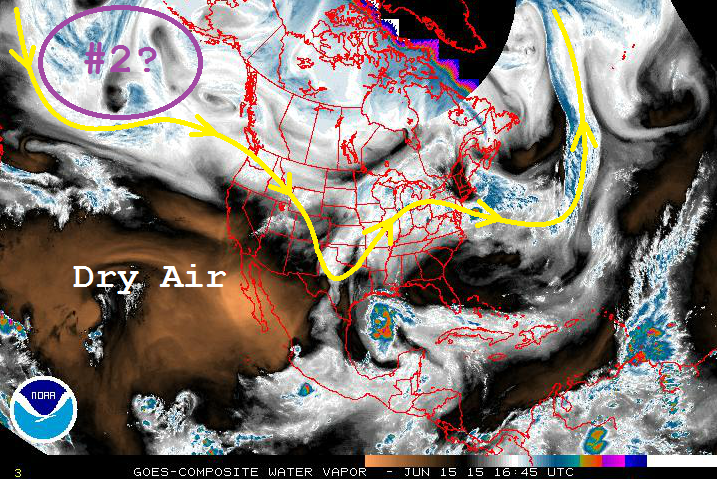
- Event #2: Saturday (06-20-2015) through Monday (06-22-2015)
- This event is currently hanging out over the northern Pacific Ocean, and will make its way towards the western United States over the coming days. As it does so, the Southwest Ridge will break down a bit, allowing for cooler temperatures and a few more showers and thunderstorms to return during this period. At this time, the exact track of the disturbance and the amount of moisture that will be present is not clear, and no flood threat is apparent.
Event #1: Tuesday (06-16-2015) through Thursday (06-18-2015)
Elevated Flood Threat Developing
Event #1 will be marked by lessening moisture as each day passes, thanks to the building high pressure ridge over the region. Wednesday will be the most active day of the three thanks to a passing surface cool front, with scattered strong-to-severe thunderstorms capable of producing heavy rainfall. With snowmelt continuing, and soils remaining saturated, runoff will be enhanced from any thunderstorm. Pay attention to the daily Flood Threat Bulletin for up-to-date information.

Event #2: Saturday (06-20-2015) through Monday (06-22-2015)
No Flood Threat Apparent
As eluded to above, this event is still coming into focus. With moisture and the specific storm track still uncertain, no precipitation map will be included in this FTO. Look for an update in Thursday’s edition of the Flood Threat Outlook.