Issue Date: June 11th, 2015
Issue Time: 3:00PM MDT
Valid Dates: June 12 – June 26
By this time of year, the sprawling high pressure normally positioned over the southwest United States begins to gain strength and shut down disturbances as they attempt to cross the west coast. The desert southwest is usually dry, awaiting the monsoonal moisture as the land mass slowly heats up relative to the cooler ocean. How do we know this is not a typical year? A few interesting stats: Phoenix has had 4 rainy days in June, usually a very dry month for them. Los Angeles has also recorded at least a trace of rain on four separate days in June (when they average 0.09 inches for the month). L.A. only had 5 rainy days in all of January, a month during which they average over 3 inches of rain.
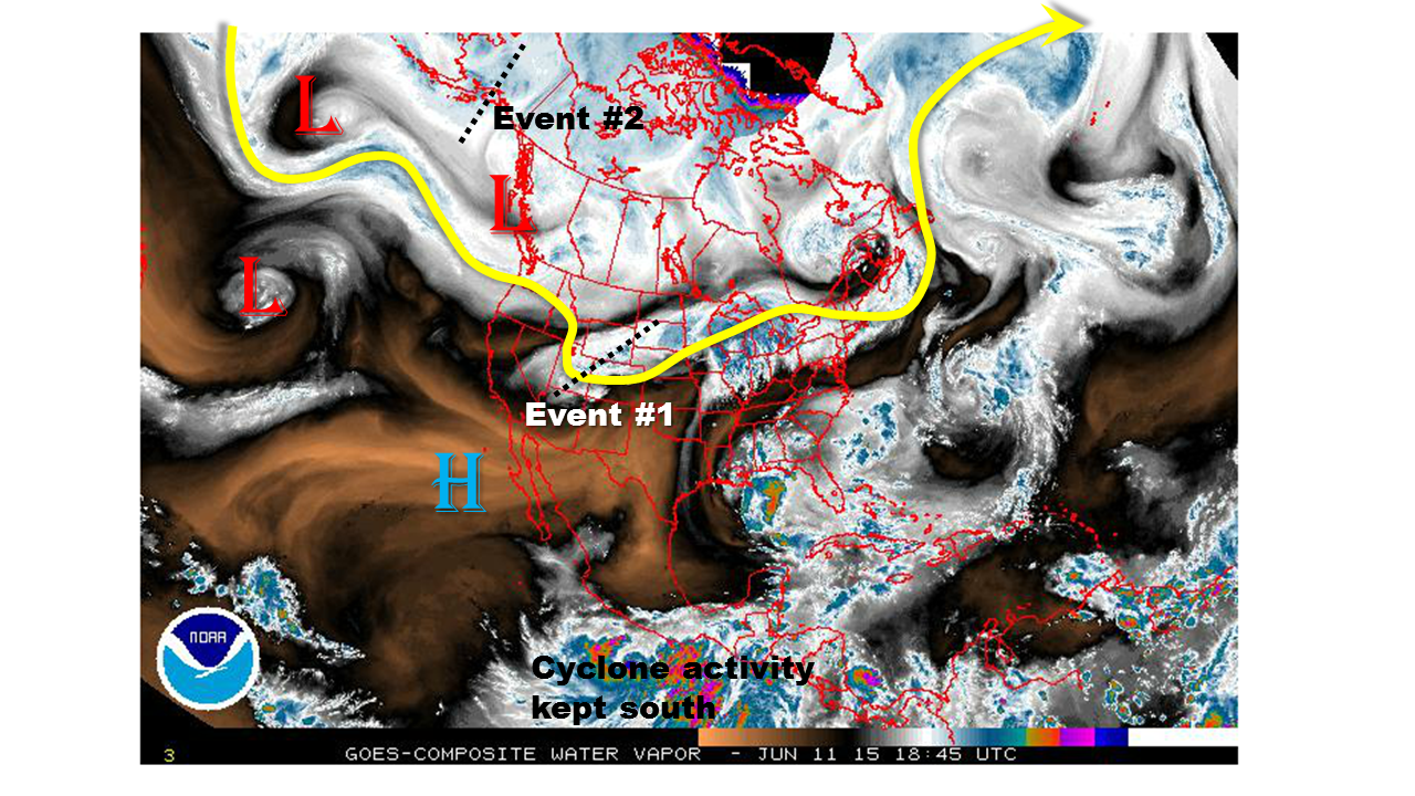
Closer to home, the water vapor image, below, shows yet another system that made it on to the west coast, and has crawled over Colorado. This disturbance will mark the first Event of this Outlook, which will feature an Elevated flood threat for Friday 6/12 through Saturday 6/13. Meanwhile, we see no shortage of additional disturbances hanging out over the central Pacific Ocean. At this time, it appears that another event will affect eastern Colorado as the disturbance currently over Alaska will propel a frontal passage on Monday 6/15.
 After the second event comes through, a lull in activity is expected for most of next week. Colorado should transition to more of a typical pattern with warm days accompanied by daily high-elevation thunderstorms, a few of which will survive as they move off the higher terrain. By the end of next week, a re-organization in the pattern looks to set up a blocking high pressure over western Canada. This is very similar to the pattern we witnessed in May, one that is conducive to rainy weather across our state. At this time, we highlight Event 3 for Friday 6/19 and Saturday 6/20, but with the subtropical ridge shutting off the connection to deeper moisture, we mark this event as one with no apparent flood threat.
Event 1: Friday (6/12) through Saturday (6/13)
An Elevated Flood Threat over the southeast quadrant of the state
The disturbance currently overhead will slowly progress eastward. Meanwhile, a cool front will drape down the east side of the Divide from the north. The cool front will effectively ban most thunderstorm activity north of I-70. But an Elevated flood threat will exist over the Southeast Plains where plenty of moisture will fuel scattered storms with very heavy rain potential.
Event 2: Monday (6/15)
Another cool front is expected to pass down from Canada setting the stage for a one day upslope event east of the Divide. This event does not look like a very heavy rain producer since instability may be lacking. However, with saturated soils and still some snowpack remaining, please stayed tuned to the Flood Threat Bulletin for updates.
Event 3: Friday (6/19) through Saturday (6/20)
A reorganization in the weather pattern will again favor the formation of a blocking high off the west coast of Canada. Between this ridge and the typical southwest U.S. “heat” ridge is a favorable avenue for disturbances to enter the western U.S. It appears at this time that such a disturbance may make its way onshore on Thursday and begin to affect Colorado by Friday, into Saturday. However, at this time, we are leaving this event as one with no apparent flood threat since it is not clear how much moisture the system will have to work with.
