Issue Date: 6/18/2015
Issue Time: 2:06 PM
Summertime is finally here in Colorado, with temperatures continuing to climb and sunshine begging for outdoor activities. All of this good news makes the FTO easier, and harder, at the same time. But how can things be easier and harder at the same time? Put simply, as long as the southwestern high-pressure ridge is in control, the forecast becomes more of a persistence forecast, with each day seeing a majority of sunshine and warmth. However, this also makes it more difficult on the forecaster to identify in the extended time-frame when disturbances will break down that ridge, how much moisture will be available, and will there be any surface fronts to focus heavy rain/stronger thunderstorms? With all of that said, in this 15-day FTO period, there are two “events” to focus our discussion upon…
- Event #1: Saturday (06-20-2015) through Monday (06-22-2015)
- This event was identified in Monday’s FTO as being uncertain with regards to the track of an upper-level disturbance and the amount of moisture available. All of that has come into better focus, and the answers are 1) No upper-level disturbance will be present, and 2) There will not a significant amount of moisture available, either. Two weak surface cool fronts are the culprit.
- Event #2: Wednesday (06-24-2015) through Sunday (06-28-2015)
- This event is much like Event #1, with no upper-level disturbance being present to bring about widespread showers and thunderstorms. Instead, this event takes place under the upper-level ridge and is the result of that ridge shifting eastward, bringing moist, southwesterly flow back into Colorado. This event has the looks of a “monsoon-type” moisture surge, but at this time how much moisture will accompany the surge is in question.
Things to watch after Event #1:
As mentioned above, Event #2 bears watching in the coming days. The amount of moisture that becomes available will be of utmost importance to any possible flood threat development. Aside from that, the HEAT IS ON. This 15-day period will be the hottest of the year so far, with 90-100 F high temperatures likely across the plains. This is all thanks to the high-pressure ridge that is will maintain its presence over the southwestern US, keeping upper-level disturbances and widespread cloud cover away from Colorado.
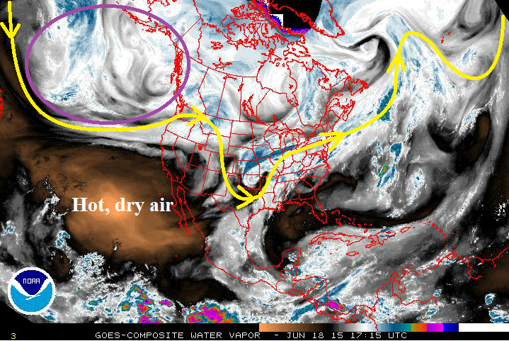
One other note: As time progresses, and we get to Monday’s FTO, the area circled in purple on the water vapor image will be important to watch. At this time, it appears to be a semi-permanent trough feature as the southwestern ridge builds and strengthens. That trough will shoot disturbances to the east every couple of days, but at this time, it appears that those will stay north of Colorado. Should the ridge breakdown more than is currently expected, we will need to keep our eyes on that region.
Saturday (06-20-2015) through Monday (06-22-2015)
No Flood Threat, More Bark than Bite from Isolated Thunderstorms
With no upper-level disturbance present, this event is focused solely on two, weak, surface cool fronts that will drop across Eastern Colorado on Friday and Sunday. These fronts will work beneath warm air aloft, and that warm air aloft will cap off much of the environment. Only isolated storms are expected over the plains, with a few isolated, diurnally-driven thunderstorms over the higher terrain; typical of summertime in Colorado. All precipitation totals look to remain under 0.5 inch.
Event #2: Wednesday (06-24-2015) through Sunday (06-28-2015)
No Flood Threat Apparent, Details Still Coming Into Focus
With high-pressure ridging aloft building across the southwestern United States, no upper-level disturbance will be present during this “event” period. Instead, the focus for this event will be on a moisture surge from the southwest, thanks to the ridge shifting eastward just a bit during this time. It is uncertain how much moisture will be present, as it is completely dependent on two things: 1) How far eastward will the ridge shift, and 2) Can a surface low developing over the northern United States strengthen enough to pull Gulf moisture northward into Eastern Colorado before it moves eastward towards the Great Lakes?
With the knowledge of the uncertainties in mind, the following precipitation map is subject to change. Be sure to check in on Monday’s FTO for an update to this period.


