FTO 07-02-2015: Two Elevated Flood Threat Events in the Next 5 Days

Issue Date: 7/2/2015
Issue Time: 2:02 PM

Threat_Timeline_20150702

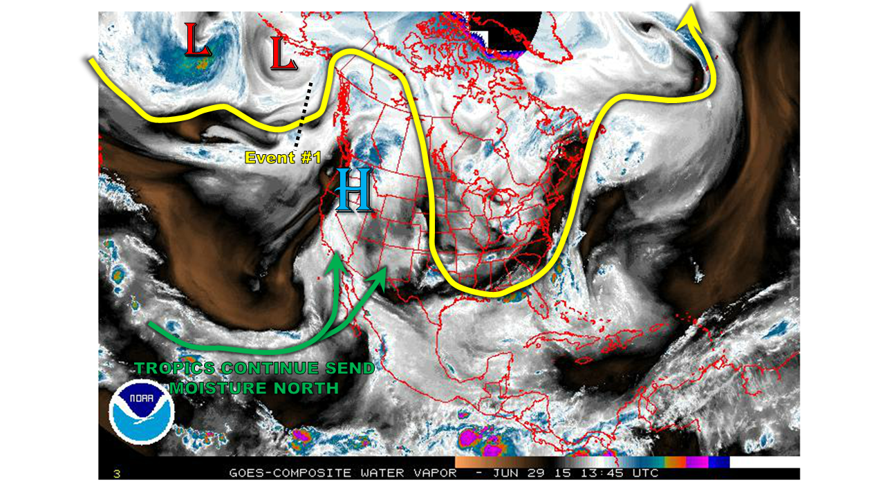
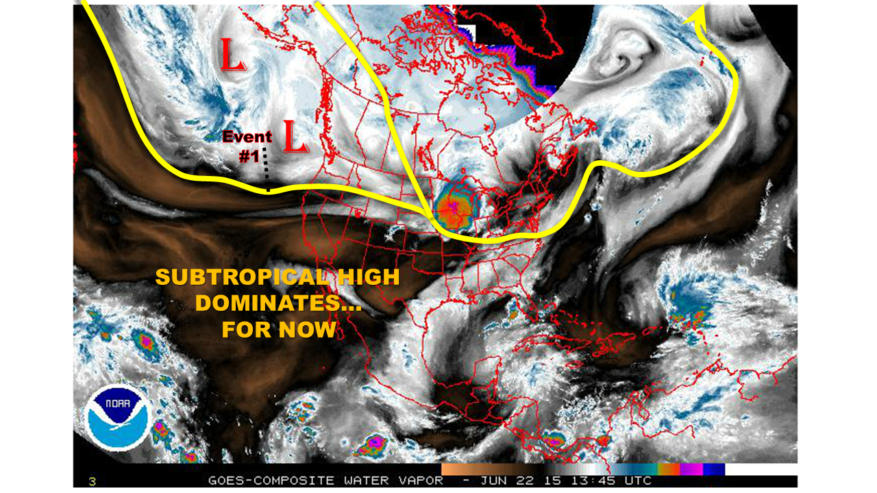
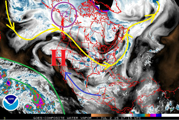
If you have grown tired of hearing about the upper-level ridge over the western US then this FTO is not going to bring you any relief. True to this time of year, this ridge has remained entrenched and is winning just about every fight with upper-level lows trying to break it down. This will likely remain the case over the next 15 days, as the defiant ridge hangs on. Underneath this ridge, several brief surges of subtropical moisture has made its way into Colorado, mainly following the blue arrow on the water vapor image below. The deep moisture we typically associate with the SW monsoon has remained over the Eastern Pacific, confined in the region outlined in green.

WV_20150702

With that said, there are two events to discuss, both coming within the next 5 days. After that time, it appears that the upper-level ridge takes its place in a location favorable to drying Colorado out. However, as we have become accustomed to this summer, the above average spring rains have resulted in sufficient water availability in our soils. This will lead to the continued pattern of isolated diurnal thunderstorms throughout the remainder of the period, with little-to-no flooding expected. So, without further ado, let’s get back to the two events at hand…

  • Event #1: Friday (07-03-2015)
    • The remaining moisture from the latest surge, and little change to the upper-level pattern, will provide one more day of showers and thunderstorms capable of heavy rain. On Saturday, the upper-level ridge will flatten out and the deeper moisture will move south of Colorado.
  • Event #2: Sunday (07-05-2015) through Tuesday (07-07-2015)
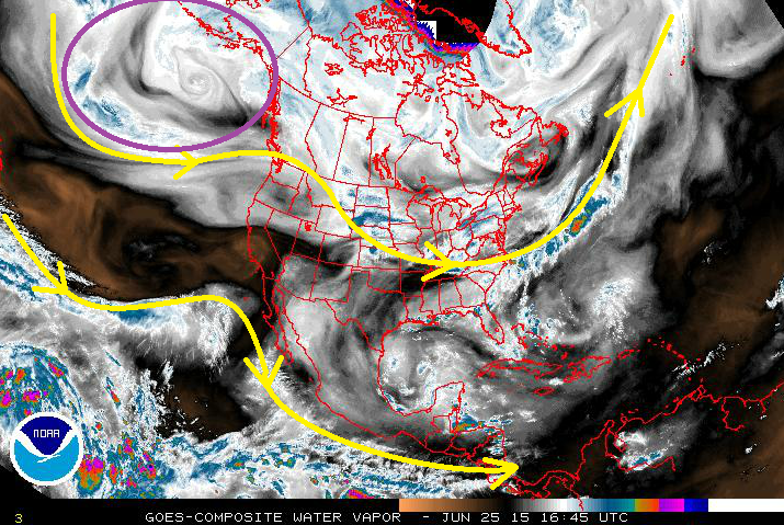
    • Event #2 shows up well in the water vapor image below, circled in purple. This will ride the ridge, so to speak, with the main upper-level low moving into the Northern Plains. Trailing energy associated with that low will track across Colorado, pushing a cool front through the plains Sunday night/Monday morning. Showers and thunderstorms associated with these features will last through Tuesday, before the ridge flattens out again, bringing drier, westerly flow once again.

Event #1: Friday (07-03-2015)

Elevated Flood Threat East of the Divide as Moist, Upslope Flow Persists

Little change in the upper-level pattern between today and tomorrow, leaving tomorrow with an Elevated Flood Threat. Moist, upslope flow will persist east of the mountains, leaving deeper moisture in place across the lower elevations and into the foothills and Front Range. Daytime heating will combine with the moisture to create sufficient instability for the production of a few strong-to-severe storms, so this threat will need to be monitored, as well.

Legend

Event #2: Sunday (07-05-2015) through Tuesday (07-07-2015)

Elevated Flood Threat Developing as Deep Moisture and Upslope flow Returns

As the main upper-level low moves into the Northern Plains, the trailing energy will track across Colorado, pushing a cool front through the plains Sunday night/Monday morning. East of the mountains, this cool front will provide upslope flow, driving moisture back into the foothills and bringing the threat of heavy rain back to the Urban Corridor, Palmer Ridge, Northeast Plains, Southeast Plains, and Raton Ridge. Over the high country, precipitable water values will be sufficiently high (near 1 inch) to create efficient rainfall within scattered thunderstorms driven by the upper-level energy and daytime heating. The upper-level ridge will begin to flatten late Tuesday/early Wednesday morning and allow the mid-levels to dry out leading into mid-week.

Legend

FTO 06-29-2015: RIDGE WILL CONTINUE TO DOMINATE, BUT NOT WITHOUT SOME RAINFALL

Issue Date: 6/29/2015
Issue Time: 1:50PM

threat_time.20150629

Over the past week or two, it has been both fascinating and impressive to watch the atmosphere generate some noteworthy thunderstorms given unfavorable conditions in the upper atmosphere (courtesy of the famous upper-level high pressure system). Fortunately, all of these storms have been very localized in both space and time, resulting in little to no flooding across the state. So why has the atmosphere been “surprisingly” active? The best explanation is that the May rains have resulted in a deep water source in our soils that has maintained above average near-surface moisture levels for the greater part of 7 weeks now. This increases in the odds of thunderstorms, even when upper-level conditions would suggest otherwise.

watervapor_20150629

Over this Outlook period, which covers through July 14th, we expect similar conditions to continue. The water vapor image, above, shows the upper-level ridge is back in full force this morning. It is causing near record hot temperatures across the Pacific northwest. The ridge’s intensity will pulse up and down over the next two weeks, while its position will slightly wobble. However, in general it will preclude any kind of organized flood threat across Colorado. Meanwhile, the Tropical Pacific remains active with daily thunderstorm activity sending moisture northeastward into Mexico and the southwest U.S. However, this moisture has, thus far, not made it all the way into Colorado.

Collectively, two particular features are identified in this Outlook that may produce more widespread rainfall, which are described below. At this time, the 4th of July weekend looks to be mostly dry, though there may still be isolated thunderstorms across the higher elevations east of the Continental Divide.

  • Event #1: Thursday (7/2) – Friday (6/3)
    • No apparent flood threat as a disturbance and weak cool front combine to increase shower and thunderstorm chances across mainly southeast Colorado
  • Event #2: Tuesday (7/7) through Thursday (7/9)
    • No apparent flood threat as the high pressure ridge scoots east and allows for monsoonal flow to help thunderstorms form west of the Divide

Event 1: Thursday (7/2) – Friday (7/3)

No apparent flood threat

A wave currently over the Pacific, will drift “over the top” of the ridge and combine with a Pacific cool front to increase shower and thunderstorm activity. The greatest chances and coverage will be over the Southeast Plains. While rain totals may approach 2 inches over isolated regions, this will be spread out over a two day period and will occur over mostly flat terrain that can accommodate more rainfall before runoff becomes a problem. Thus, we do not anticipate a flood threat.

Legend


Event 2: Tuesday (7/7) – Thursday (7/9)

No apparent flood threat

After Event #1, the high pressure ridge will intensify briefly, but then scoot to the east of Colorado. This will open up the gates for some monsoonal moisture to make its way into the southwest part of the state. At this time, no apparent threat is visible, but rainfall amounts up to 1.5 inches may occur over a multi-day period in the climatologically favored San Juan mountains.

Legend

Longer-range outlook

We have repeatedly made reference to Eastern Pacific weather conditions this season, with all eyes being focused on the strengthening El Nino. Today, instead of looking at sea-surface temperatures, we show the impact of El Nino through the atmosphere. The three maps below show anomalies of outgoing radiation, as seen from above the earth by numerous satellites. The top two maps show the latest daily anomaly and weekly anomalies, while the bottom map is the monthly anomaly. The key thing to note is that blue and purple colors denote where below normal radiation is leaving our planet (and vice versa for yellow/red colors). This generally implies above normal thunderstorm activity, as storm clouds are much colder than the atmosphere would otherwise be in the absence. Note that all three maps show very similar patterns! Notably, all suggest a plume of above average thunderstorm activity emanating from the deep Tropics and stretching eastward into the southwest United States and even into our state. While Colorado day-to-day weather is not exclusively tied to this, we are undoubtedly under the influence of a pattern that consistently promotes above average storm activity. And that has certainly been the case thus far this summer.

OLR

FTO 06-25-2015: Active Period Ahead

Issue Date: 6/25/2015
Issue Time: 1:45 PM

ThreatTimeline_06252015

An active period awaits Colorado during the next 15 days, even while the western US stays entrenched under an upper-level ridge. The placement of this ridge will likely leave Colorado under northwesterly flow in the upper-levels and southwesterly flow in the mid-levels. This setup lends itself to a sufficient supply of moisture, providing two main event periods. So, without further ado…

  • Event #1: Friday (6-26-2015) through Sunday (6-28-2015)
    • Low- and mid-level moisture will be sufficient to produce diurnal rounds of showers and thunderstorms each day. Weak disturbances will likely be embedded in the NW flow aloft (originating in the purple-circled area), but the main focus will need to be placed on favorable low-level areas. More on this in the discussion below.
  • Event #2: Wednesday (7-1-2015) through Monday (7-6-2015)
    • Upper-level ridging will remain in place, but the surface will be active as a few lee surface troughs/cool fronts impact Eastern Colorado. This will act to siphon moisture northward from the Gulf of Mexico into Eastern Colorado. Additionally, a SW moisture surge will arrive between July 2nd-4th, bringing deep moisture and increasing the threat of heavy rain.

WV_06252015

Event #1: Friday (6-26-2015) through Sunday (6-28-2015)

No Apparent Flood Threat, “Sweat the Small-Scale Stuff”

Typical of the summertime season, the upper-level ridge is in place across the western US, and diurnal rounds of showers and thunderstorms are expected during the afternoon and evening hours. Subtle disturbances will emerge in the NW flow aloft during this period, providing some additional support for developing thunderstorms. That is not where the main focus should lie – instead, the main focus should be in the low-levels. Surface upslope flow and/or lingering boundaries from previous days’ storms will be the focus for heavy rain threats. These features will be better addressed in the FTB, so be sure and stay up-to-date on the daily forecasts. Monday and Tuesday will also hold chances for diurnal showers and thunderstorms under the ridge, but moisture will be less as the next surge gathers for Event #2.

Legend

Event #2: Wednesday (7-1-2015) through Monday (7-6-2015)

Elevated Flood Threat as the Surface becomes Active and a SW Moisture Surge Arrives

The upper-level ridging is not going anywhere, but the surface will become increasingly active during this period. A few lee-side troughs/cool fronts will impact eastern Colorado, providing not only a focus for thunderstorm development, but also will siphon moisture from the Gulf of Mexico into Colorado. Precipitable water values will climb over 1 inch across the Palmer Ridge, Northeast Plains, and Southeast Plains, with various surges pushing 1 inch values into the Urban Corridor, as well. Prolonged events are not expected, as the surface features will be fairly transient, but upslope flow into the foothills will need to be monitored on a daily basis. The most active period will likely be July 2nd through July 4th, as a deep moisture surge arrives from the southwest, increasing the heavy rain threat.

Additionally, this period could be quite active in terms of severe weather for areas along and east of I-25. As details emerge over the next few days, the forecast will become clearer, so stay tuned for Monday’s FTO for an update.

As always, a reminder that this event is still coming into focus, and the precipitation map below will be subject to change as conditions warrant. At this time, this is what to expect from the information at hand.

Legend

FTO 06-22-2015: Subtropical High Flexes Muscle This Week, But Eventually Gives Way To First Monsoon Surge

Issue Date: 6/22/2015
Issue Time: 11:30 AM

threat_timeline.20150622

The end of June to early July is climatologically a transition period over most of Colorado. And 2015 appears to be following that script. The springtime jet stream is retreating northward, while losing strength. Meanwhile, the land-sea temperature contrast is not quite strong enough to induce the moisture laden monsoonal flow that typically establishes itself by mid July. As we see in the water vapor image, below, the short-term weather (or lack thereof!) will be exclusively dictated by subtropical high. However, after the 4th of July, model guidance suggests that the door will be open to the first push of monsoonal moisture.

watervapor_20150622

During this Outlook period, covering 6/23 through 7/7, we see two precipitation “Events”:

  • Event #1: Thursday (6/25) – Friday (6/26)
    • No apparent flood threat as a weak disturbance increases rainfall chances mainly for the Southeast Plains
  • Event #2: Sunday (7/5) through Tuesday (7/7)
    • No apparent flood threat (at this time) as monsoonal moisture will promote thunderstorm activity across the southern part of the state

Event 1: Thursday (6/25) – Friday (6/26)

No apparent flood threat

A weak “ridge-rider” type disturbance will increase thunderstorm chances mainly across the Southeast Plains on Thursday and Friday. However, rainfall is anticipated to stay in the 0.5 to 1 inch range and no flooding concerns are anticipated.

Legend

Event 2: Sunday (7/5) – Tuesday (7/7)

No apparent flood threat

After dominating the scene for a 7-10 day period, the subtropical high pressure ridge will weaken and allow the season’s first monsoon surge to visit Colorado. While there is not enough confidence yet to issue for an Elevated threat, we do expect rainfall chances to be highest in the climatologically favored southern half of the state. At this time, rainfall is expected to stay in the 0.5 to 1 inch range.


Legend

Longer-range outlook

In the longer-range, conditions are still very conducive to higher than normal precipitation across most of Colorado. Most of this anticipation is based on a continually strengthening El Nino in the Pacific Ocean. The chart below shows that one measure of El Nino, the 3.4 Index, is now the highest since 2010. Almost all longer-range guidance continues to suggest a maintenance or further strengthening of El Nino in the fall. This kind of consensus increases confidence that the above average rainfall that started in May will continue.

nino3.4_series