Issue Date: 6/29/2015
Issue Time: 1:50PM

Over the past week or two, it has been both fascinating and impressive to watch the atmosphere generate some noteworthy thunderstorms given unfavorable conditions in the upper atmosphere (courtesy of the famous upper-level high pressure system). Fortunately, all of these storms have been very localized in both space and time, resulting in little to no flooding across the state. So why has the atmosphere been “surprisingly” active? The best explanation is that the May rains have resulted in a deep water source in our soils that has maintained above average near-surface moisture levels for the greater part of 7 weeks now. This increases in the odds of thunderstorms, even when upper-level conditions would suggest otherwise.
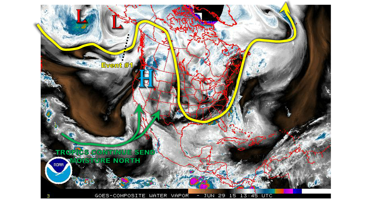
Over this Outlook period, which covers through July 14th, we expect similar conditions to continue. The water vapor image, above, shows the upper-level ridge is back in full force this morning. It is causing near record hot temperatures across the Pacific northwest. The ridge’s intensity will pulse up and down over the next two weeks, while its position will slightly wobble. However, in general it will preclude any kind of organized flood threat across Colorado. Meanwhile, the Tropical Pacific remains active with daily thunderstorm activity sending moisture northeastward into Mexico and the southwest U.S. However, this moisture has, thus far, not made it all the way into Colorado.
Collectively, two particular features are identified in this Outlook that may produce more widespread rainfall, which are described below. At this time, the 4th of July weekend looks to be mostly dry, though there may still be isolated thunderstorms across the higher elevations east of the Continental Divide.
- Event #1: Thursday (7/2) – Friday (6/3)
- No apparent flood threat as a disturbance and weak cool front combine to increase shower and thunderstorm chances across mainly southeast Colorado
- Event #2: Tuesday (7/7) through Thursday (7/9)
- No apparent flood threat as the high pressure ridge scoots east and allows for monsoonal flow to help thunderstorms form west of the Divide
Event 1: Thursday (7/2) – Friday (7/3)
No apparent flood threat
A wave currently over the Pacific, will drift “over the top” of the ridge and combine with a Pacific cool front to increase shower and thunderstorm activity. The greatest chances and coverage will be over the Southeast Plains. While rain totals may approach 2 inches over isolated regions, this will be spread out over a two day period and will occur over mostly flat terrain that can accommodate more rainfall before runoff becomes a problem. Thus, we do not anticipate a flood threat.

Event 2: Tuesday (7/7) – Thursday (7/9)
No apparent flood threat
After Event #1, the high pressure ridge will intensify briefly, but then scoot to the east of Colorado. This will open up the gates for some monsoonal moisture to make its way into the southwest part of the state. At this time, no apparent threat is visible, but rainfall amounts up to 1.5 inches may occur over a multi-day period in the climatologically favored San Juan mountains.
Longer-range outlook
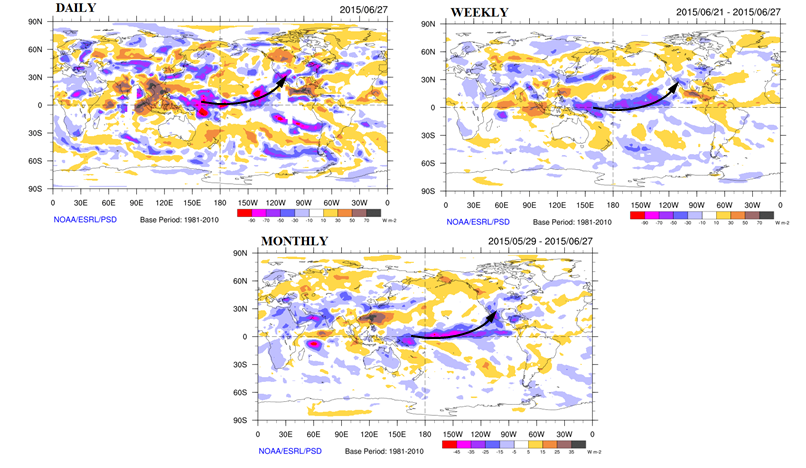
We have repeatedly made reference to Eastern Pacific weather conditions this season, with all eyes being focused on the strengthening El Nino. Today, instead of looking at sea-surface temperatures, we show the impact of El Nino through the atmosphere. The three maps below show anomalies of outgoing radiation, as seen from above the earth by numerous satellites. The top two maps show the latest daily anomaly and weekly anomalies, while the bottom map is the monthly anomaly. The key thing to note is that blue and purple colors denote where below normal radiation is leaving our planet (and vice versa for yellow/red colors). This generally implies above normal thunderstorm activity, as storm clouds are much colder than the atmosphere would otherwise be in the absence. Note that all three maps show very similar patterns! Notably, all suggest a plume of above average thunderstorm activity emanating from the deep Tropics and stretching eastward into the southwest United States and even into our state. While Colorado day-to-day weather is not exclusively tied to this, we are undoubtedly under the influence of a pattern that consistently promotes above average storm activity. And that has certainly been the case thus far this summer.