Issue Date: 6/25/2015
Issue Time: 1:45 PM

An active period awaits Colorado during the next 15 days, even while the western US stays entrenched under an upper-level ridge. The placement of this ridge will likely leave Colorado under northwesterly flow in the upper-levels and southwesterly flow in the mid-levels. This setup lends itself to a sufficient supply of moisture, providing two main event periods. So, without further ado…
- Event #1: Friday (6-26-2015) through Sunday (6-28-2015)
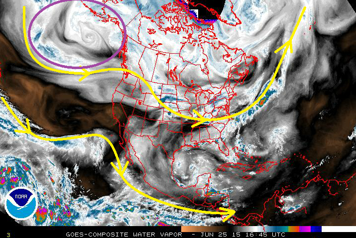
- Low- and mid-level moisture will be sufficient to produce diurnal rounds of showers and thunderstorms each day. Weak disturbances will likely be embedded in the NW flow aloft (originating in the purple-circled area), but the main focus will need to be placed on favorable low-level areas. More on this in the discussion below.
- Event #2: Wednesday (7-1-2015) through Monday (7-6-2015)
- Upper-level ridging will remain in place, but the surface will be active as a few lee surface troughs/cool fronts impact Eastern Colorado. This will act to siphon moisture northward from the Gulf of Mexico into Eastern Colorado. Additionally, a SW moisture surge will arrive between July 2nd-4th, bringing deep moisture and increasing the threat of heavy rain.
Event #1: Friday (6-26-2015) through Sunday (6-28-2015)
No Apparent Flood Threat, “Sweat the Small-Scale Stuff”
Typical of the summertime season, the upper-level ridge is in place across the western US, and diurnal rounds of showers and thunderstorms are expected during the afternoon and evening hours. Subtle disturbances will emerge in the NW flow aloft during this period, providing some additional support for developing thunderstorms. That is not where the main focus should lie – instead, the main focus should be in the low-levels. Surface upslope flow and/or lingering boundaries from previous days’ storms will be the focus for heavy rain threats. These features will be better addressed in the FTB, so be sure and stay up-to-date on the daily forecasts. Monday and Tuesday will also hold chances for diurnal showers and thunderstorms under the ridge, but moisture will be less as the next surge gathers for Event #2.

Event #2: Wednesday (7-1-2015) through Monday (7-6-2015)
Elevated Flood Threat as the Surface becomes Active and a SW Moisture Surge Arrives
The upper-level ridging is not going anywhere, but the surface will become increasingly active during this period. A few lee-side troughs/cool fronts will impact eastern Colorado, providing not only a focus for thunderstorm development, but also will siphon moisture from the Gulf of Mexico into Colorado. Precipitable water values will climb over 1 inch across the Palmer Ridge, Northeast Plains, and Southeast Plains, with various surges pushing 1 inch values into the Urban Corridor, as well. Prolonged events are not expected, as the surface features will be fairly transient, but upslope flow into the foothills will need to be monitored on a daily basis. The most active period will likely be July 2nd through July 4th, as a deep moisture surge arrives from the southwest, increasing the heavy rain threat.
Additionally, this period could be quite active in terms of severe weather for areas along and east of I-25. As details emerge over the next few days, the forecast will become clearer, so stay tuned for Monday’s FTO for an update.
As always, a reminder that this event is still coming into focus, and the precipitation map below will be subject to change as conditions warrant. At this time, this is what to expect from the information at hand.