Issue Date: 7/2/2015
Issue Time: 2:02 PM
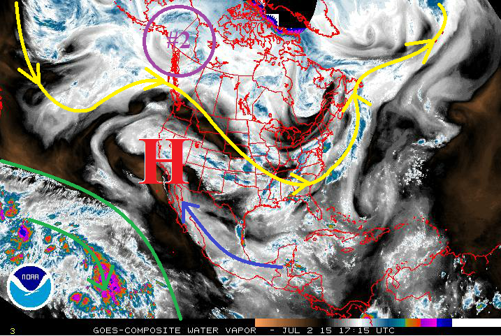
If you have grown tired of hearing about the upper-level ridge over the western US then this FTO is not going to bring you any relief. True to this time of year, this ridge has remained entrenched and is winning just about every fight with upper-level lows trying to break it down. This will likely remain the case over the next 15 days, as the defiant ridge hangs on. Underneath this ridge, several brief surges of subtropical moisture has made its way into Colorado, mainly following the blue arrow on the water vapor image below. The deep moisture we typically associate with the SW monsoon has remained over the Eastern Pacific, confined in the region outlined in green.
With that said, there are two events to discuss, both coming within the next 5 days. After that time, it appears that the upper-level ridge takes its place in a location favorable to drying Colorado out. However, as we have become accustomed to this summer, the above average spring rains have resulted in sufficient water availability in our soils. This will lead to the continued pattern of isolated diurnal thunderstorms throughout the remainder of the period, with little-to-no flooding expected. So, without further ado, let’s get back to the two events at hand…
- Event #1: Friday (07-03-2015)
- The remaining moisture from the latest surge, and little change to the upper-level pattern, will provide one more day of showers and thunderstorms capable of heavy rain. On Saturday, the upper-level ridge will flatten out and the deeper moisture will move south of Colorado.
- Event #2: Sunday (07-05-2015) through Tuesday (07-07-2015)
- Event #2 shows up well in the water vapor image below, circled in purple. This will ride the ridge, so to speak, with the main upper-level low moving into the Northern Plains. Trailing energy associated with that low will track across Colorado, pushing a cool front through the plains Sunday night/Monday morning. Showers and thunderstorms associated with these features will last through Tuesday, before the ridge flattens out again, bringing drier, westerly flow once again.
Event #1: Friday (07-03-2015)
Elevated Flood Threat East of the Divide as Moist, Upslope Flow Persists
Little change in the upper-level pattern between today and tomorrow, leaving tomorrow with an Elevated Flood Threat. Moist, upslope flow will persist east of the mountains, leaving deeper moisture in place across the lower elevations and into the foothills and Front Range. Daytime heating will combine with the moisture to create sufficient instability for the production of a few strong-to-severe storms, so this threat will need to be monitored, as well.
Event #2: Sunday (07-05-2015) through Tuesday (07-07-2015)
Elevated Flood Threat Developing as Deep Moisture and Upslope flow Returns
As the main upper-level low moves into the Northern Plains, the trailing energy will track across Colorado, pushing a cool front through the plains Sunday night/Monday morning. East of the mountains, this cool front will provide upslope flow, driving moisture back into the foothills and bringing the threat of heavy rain back to the Urban Corridor, Palmer Ridge, Northeast Plains, Southeast Plains, and Raton Ridge. Over the high country, precipitable water values will be sufficiently high (near 1 inch) to create efficient rainfall within scattered thunderstorms driven by the upper-level energy and daytime heating. The upper-level ridge will begin to flatten late Tuesday/early Wednesday morning and allow the mid-levels to dry out leading into mid-week.


