FTO 07-16-2015: Under Strengthening El Nino, No Let Up In Heavy Rain Threat Over Colorado

Issue Date: 7/16/2015
Issue Time: 1:15PM

threat_timeline.20150716

OVERVIEW

El Nino and La Nina events receive quite a lot of publicity from media. And for a good reason. These events provide for some of the most consistent skill in long-range forecasts (weeks to months). We have consistently alluded to the strengthening El Nino in the last few months of the Flood Threat Outlook. By almost all measures, a moderate El Nino is already present.

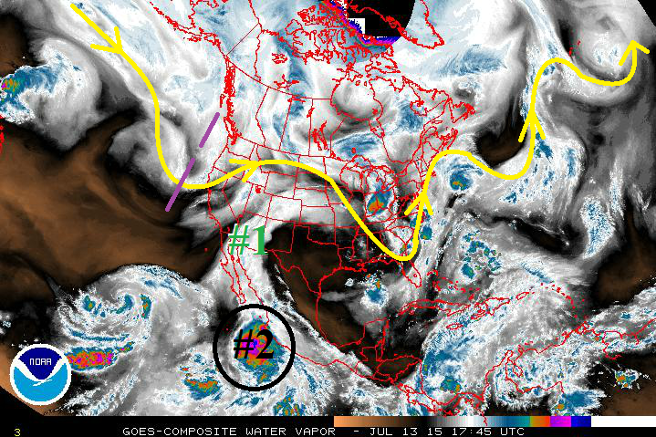
So how does this all relate to the weather over the next 15 days here at home? Two consistent signals associated with El Nino events are (i) above normal tropical cyclone activity, and (ii) more frequent disturbances across the Southwest United States. In fact, as today’s water vapor image shows, we see both. An active Pacific storm track will continue to conspire with plenty of tropical moisture to keep rainfall chances in our forecast over the next two weeks. It is interesting to note that the Eastern Pacific tropical cyclone activity is running about 3 times above normal for this time of year.

watervapor_20150716
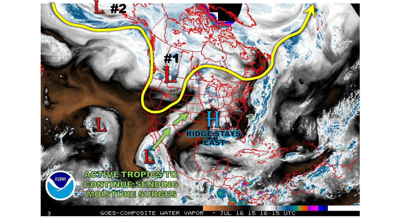
Let’s move on to the specifics. We anticipate two organized rainfall chances over the next 15 days. The first will be caused by a strengthening disturbance currently over the west coast. Meanwhile, the second event is far across the Pacific Ocean currently, but is anticipated to arrive onto the west coast of North America late next week. Due to the high anticipated moisture content, an Elevated flood threat is issued for both events. After next weekend (starting Monday 7/27), we will likely see a few days of hot and drier weather. But in the longer range, things continue to look active for thunderstorm activity across Colorado.

Event #1: Saturday (7/18) through Monday (7/20)

An Elevated flood threat, both east and west of the Divide.

An upper-level disturbances and surface cool front will give Colorado several days of widespread thunderstorm activity starting Saturday. West of the Divide, heavy downpours will be possible, with total 3-day rainfall amounts up to 2.0 inches. East of the Divide, heavy rainfall will be a threat, along with hail and gusty winds due to an unstable atmosphere and a jet stream overhead. Although widespread flooding is not anticipated, a flash flood risk, along with mud flows and debris slides in the higher terrain, will be likely over the 3-day period.

Legend

Event #2: Thursday (7/23) – Sunday (7/26)

An Elevated flood threat mostly for the higher terrain of Central Colorado

After a few days of quieter weather, another large-scale disturbance is likely to enter the west coast of the United States. This will support another multi-day episode of heavy rainfall, this time focused over the higher terrain and west of the Divide. The rainfall threat over the Eastern Plains is not as certain at this point, because a strong high pressure ridge may press into the area. Due to a stream of tropical moisture from ongoing and developing tropical cyclone activity in the Eastern Pacific, heavy downpours will be likely over the higher terrain. A flash flood risk, as well as debris slides and mud flows will all be possible.


Legend

FTO 07-13-2015: 2 out of 3 Events Marked as Elevated Flood Threats

Issue Date: 7/13/2015
Issue Time: 1:55 PM

Threat_Timeline_20150713

The active and wet pattern will continue for Colorado over the next 15 days as the upper-level high pressure ridge struggles to maintain its position, allowing subtropical moisture to stream in from the southwest. 2 out of 3 events during this FTO period have been placed in “Elevated Flood Threat” category, and Event #2 could be raised to a “High Flood Threat” event by Thursday’s FTO; details of this continue to come together, so stay tuned. Without further ado, here are the three events that this FTO is focused on…

  • Event #1: Tuesday (07-14) through Wednesday (07-15)
    • A monsoon-type impulse of subtropical moisture that began today will continue through Wednesday. Scattered thunderstorms capable of heavy rainfall are expected west of the Divide, with more isolated-to-widely scattered activity expected east of the Divide.
  • Event #2: Saturday (7-18) through Monday (07-20)
    • After a short break from rainfall, the upper-level high pressure will shift eastward once again, bringing moist, southwesterly flow back overhead. At the same time, Tropical Storm Dolores (circled in black on the water vapor image) will continue to intensify in the Eastern Pacific (becoming Hurricane Dolores), just off the coast of Mexico. This will usher in deeper moisture and a few weak disturbances as the storm is sheared apart by a mid-/upper-level trough deepening along the West Coast.
  • Event #3: Friday (07-24) through Sunday (07-26)
    • In a pattern that seems to repeat itself, the upper-level ridge over the southwestern US will shift back eastward, allowing subtropical moisture to stream into the state once again. A couple of weak disturbances will “ride the ridge” and bring a couple of days of scattered showers and thunderstorms. Event #3 is not marked on the water vapor image below; however, the general appearance of the moisture stream will look much like Event #1 marked on the image.

WV_20150713

Event #1: Tuesday (07-14) through Wednesday (07-15)

Elevated Flood Threat as Monsoon-Type Impulse Continues

A monsoon-type impulse of subtropical moisture that began today will continue to ride northward on the western periphery of the upper-level ridge. Scattered thunderstorms capable of heavy rainfall are expected west of the Divide, which will support isolated debris slides and mud flows due to saturated soils, as well as isolated flash flooding. East of the Divide, the disturbance will cause afternoon/evening rounds of thunderstorm activity. Isolated flash flooding will be possible, mainly for urban areas where response time is quick due to impervious surfaces.

Legend

Event #2: Saturday (7-18) through Monday (07-20)

Elevated Flood Threat as Deep Moisture Lurks in the Eastern Pacific

Following Event #1, there will be a short break from rainfall as high pressure re-asserts its dominance over Colorado. Then, on Saturday, the upper-level high pressure will shift eastward in response to a deepening trough over the western US, bringing moist, southwesterly flow back overhead. At the same time, Tropical Storm/Hurricane Dolores will intensify in the Eastern Pacific, just off the coast of Mexico. This storm will likely move north-northwestward, west of the Baja California Peninsula, and the deep moisture field associated with it will likely become sheared off into the southwest flow, arriving over the weekend. Embedded with that moisture will be a couple of weak disturbances, which will likely lead to more widespread thunderstorm activity, especially over Western Colorado. Then, on Tuesday, the moisture will be briefly cut-off by the westward expansion of the upper-level high pressure. This will dry Colorado out through Thursday (07-23).

Legend

Event #3: Friday (07-24) through Sunday (07-26)

No Flood Threat Apparent

In a pattern that seems to repeat itself, the upper-level ridge over the southwestern US will shift back eastward in response to a deepening trough off over the Pacific Northwest, allowing subtropical moisture to stream into the state, once again. A couple of weak disturbances will “ride the ridge” and bring a couple of days of scattered showers and thunderstorms. The depth of the moisture available is still uncertain, so no flood threat is apparent at this time.
As quickly as it began it will end again, as the upper-level ridge shifts back westward on Monday, drying Colorado out for the remainder of this FTO period.

Legend

FTO 07-09-2015: Active Weather To Continue, Fueled By Subtropical Moisture

Issue Date: 7/9/2015
Issue Time: 3:00PM
Valid Dates: 7/10 – 7/24

Overview:

threat_timeline.20150709
“Green and wet” is an appropriate way to describe the landscape of Colorado over the past few months. After experiencing the state’s wettest May on record, June and July have not failed to disappoint in the rainfall department. With a consistently active eastern Pacific storm track, both in the tropics and subtropics, disturbances have slammed into the normally stout high-pressure over the Southwest U.S. Over the next 15 day period, covering from July 10th through the 24th, we see a continuation of the active pattern. The water vapor image, below, shows the features at hand. First, we see the upper-level low-pressure of CA. This will impact Colorado on Friday before retreating back westward. That’s right, westward: this feature will continue to influence the state in the coming period. Second, after a few days of quietness, a tropical disturbance is expected to slip to the west of the eastward-displaced southern U.S. ridge to provide more rainfall early next week. Finally, after a few more days of relatively quiet weather, things really turn interesting. There is now growing confidence that at least one tropical storm or hurricane will track far enough up the Mexican coast to feed moisture into Colorado. This will provide another elevated flood threat for a prolonged period starting sometime late next weekend.
watervapor_20150709Now, on to the details of the three expected precipitation events.

Event #1: Friday (7/10)

An Elevated flood threat, mainly for the southeast corner of state

Another major impulse from the California low pressure system will tail off and cross Colorado on Friday. Moisture will be on the decline west of the Divide, limiting rainfall to below 1 inch for most places. However, much higher moisture and instability will be present over the Plains, especially the southeast quadrant of the state. There, thunderstorm activity could provide up to 2 inches of rainfall, elevating the flood threat during the afternoon and evening.


Legend

Event #2: Monday (7/13) – Wednesday (7/15)

An Elevated flood threat both east and west of the Divide

After event #1, the ridge will briefly seize control of Colorado’s weather. Hot and mostly dry conditions are expected over the weekend with rainfall generally limited to the highest terrain, and probably not amounting to much. Thereafter, a monsoon type impulse, currently over the Tropical Pacific is expected to ride northward, on the western periphery of the retreating ridge. Monsoon type thunderstorms are expected west of the Divide, where up to 1.5 inches of rainfall may accumulate. This will continue to supported isolated debris slides and mud flows due to the saturated soils. Meanwhile, east of the Divide, the disturbance may cause a round or two of thunderstorm activity. Most action looks to be limited to the northeast Plains, where up to 2 inches of rainfall may fall. Isolated flash flooding will be possible.

Legend

Event #3: Sunday (7/19) – Wednesday (7/22)

A prolonged Elevated flood threat, mainly west of the Divide

Following event #2 will be another short respite from rainfall as the high pressure again re-exerts dominance. Just like before, this will be temporary. The combination of tropical moisture and subtropical dynamics will conspire to raise the flood threat west of the Divide where over 2 inches of rainfall will likely fall over a prolonged period. We are currently putting this period into the Elevated flood threat category. However, given more details, this may be a high flood threat event for the higher terrain of our state. Please stay tuned to subsequent Flood Threat Outlooks.

Legend

FTO 07-06-2015: High Flood Threat Developing for Event #1

Issue Date: 7/6/2015
Issue Time: 10:37 AM

ThreatTimeline_07062015

Mother Nature heard our rumblings about the upper-level ridge’s persistence, and has decided to throw a fairly active “wave train” at Colorado. This “wave train” is very visible in the water vapor image below, highlighted by the yellow line. From West to East, you can count 4-5 full waves, with the two waves upstream of Colorado being of importance to this forecast. Event #1 is the closed, upper-level low (circled in purple), and Event #2 is the upper-level trough shown by the black-dashed lines. These two large-scale disturbances will provide the focus for this 15-day period, so without further ado, let’s get right to it.

  • Event #1: Tuesday (07-07-2015) through Friday (07-10-2015)
    • Plenty of subtropical moisture will remain entrenched across Colorado as the approaching upper-level low (circled in purple) promotes continued moist, southwesterly flow aloft throughout the event. With the deep moisture in place, heavy rain from thunderstorms will be a significant threat. The moisture will be cut off on Saturday as the upper-level low moves east of the state.
  • Event #2: Wednesday (07-15-2015) through Thursday (07-16-2015)
    • Deep, subtropical moisture will overspread Colorado, once again, in the southwesterly flow ahead of the next upper-level trough (marked by the black-dashed line). The High Country will be under the gun for scattered thunderstorms producing heavy rain, and the Eastern Plains will be dealing with strong thunderstorms due to a developing lee-trough/cool front. The upper-level trough will move east of Colorado on Friday, ushering in drier air as a surface high stabilizes the atmosphere a bit.

07062015_WV

After Event #2, upper-level ridging will take over again for a few days, but the active wave train will continue. Another upper-level trough appears poised to push through just after the 21st. Keep an eye on future FTO’s for updates on this developing situation. Mother Nature doesn’t appear ready to relax.

Tuesday (07-07-2015) through Friday (07-10-2015)

High Flood Threat As Deep, Subtropical Moisture Persists over Colorado

The approaching upper-level low will continue the transport of subtropical moisture into Colorado. Precipitable water values across the state will stay near, or above, 1 inch through the entirety of the event. The best coverage of storms, widespread at times, will be across the High Country and adjacent lower elevations. One thing is certain, heavy rain will be a threat with any thunderstorms with the sheer amount of moisture available.

Additionally, a surface dry line will develop over the Eastern Plains, bringing the threat of severe weather back to Eastern Colorado. Large hail, lightning, and strong winds will be the primary threats, but heavy rain will also be attendant.

Be sure to check back in daily with the Flood Threat Bulletin to stay up-to-date on this event.

Legend

Event #2: Wednesday (07-15-2015) through Thursday (07-16-2015)

Elevated Flood Threat Developing as Subtropical Moisture Returns

Subtropical moisture will overspread the state again, ahead of an upper-level trough. As the trough approaches and passes over the Northern Rockies, a surface low/lee-side trough will develop, transporting low-level Gulf Moisture into Eastern Colorado. This trough will become a cool front as the surface low tracks eastward across the US/Canadian border. Due to this, severe weather will be possible across the Northeast Plains, Southeast Plains, and Palmer Ridge regions.

Exacerbating the potential heavy rain issues from this event will be the widespread rainfall from Event #1. Not only will this promote unstable soils, but will also leave above-average low-level moisture across Colorado. As we have experienced already this summer, the low-level moisture has promoted several heavy rain events, especially along the Urban Corridor.

Legend