Issue Date: 7/9/2015
Issue Time: 3:00PM
Valid Dates: 7/10 – 7/24
Overview:

“Green and wet” is an appropriate way to describe the landscape of Colorado over the past few months. After experiencing the state’s wettest May on record, June and July have not failed to disappoint in the rainfall department. With a consistently active eastern Pacific storm track, both in the tropics and subtropics, disturbances have slammed into the normally stout high-pressure over the Southwest U.S. Over the next 15 day period, covering from July 10th through the 24th, we see a continuation of the active pattern. The water vapor image, below, shows the features at hand. First, we see the upper-level low-pressure of CA. This will impact Colorado on Friday before retreating back westward. That’s right, westward: this feature will continue to influence the state in the coming period. Second, after a few days of quietness, a tropical disturbance is expected to slip to the west of the eastward-displaced southern U.S. ridge to provide more rainfall early next week. Finally, after a few more days of relatively quiet weather, things really turn interesting. There is now growing confidence that at least one tropical storm or hurricane will track far enough up the Mexican coast to feed moisture into Colorado. This will provide another elevated flood threat for a prolonged period starting sometime late next weekend.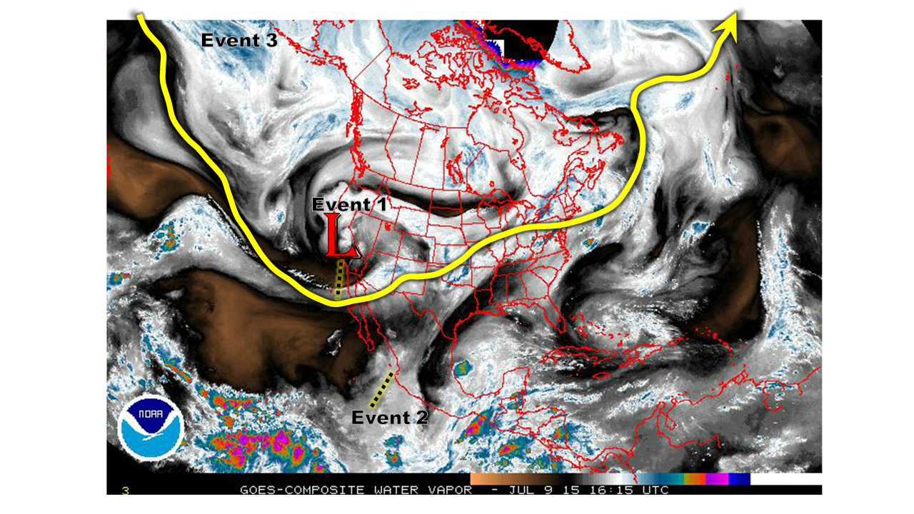 Now, on to the details of the three expected precipitation events.
Event #1: Friday (7/10)
An Elevated flood threat, mainly for the southeast corner of state
Another major impulse from the California low pressure system will tail off and cross Colorado on Friday. Moisture will be on the decline west of the Divide, limiting rainfall to below 1 inch for most places. However, much higher moisture and instability will be present over the Plains, especially the southeast quadrant of the state. There, thunderstorm activity could provide up to 2 inches of rainfall, elevating the flood threat during the afternoon and evening.

Event #2: Monday (7/13) – Wednesday (7/15)
An Elevated flood threat both east and west of the Divide
After event #1, the ridge will briefly seize control of Colorado’s weather. Hot and mostly dry conditions are expected over the weekend with rainfall generally limited to the highest terrain, and probably not amounting to much. Thereafter, a monsoon type impulse, currently over the Tropical Pacific is expected to ride northward, on the western periphery of the retreating ridge. Monsoon type thunderstorms are expected west of the Divide, where up to 1.5 inches of rainfall may accumulate. This will continue to supported isolated debris slides and mud flows due to the saturated soils. Meanwhile, east of the Divide, the disturbance may cause a round or two of thunderstorm activity. Most action looks to be limited to the northeast Plains, where up to 2 inches of rainfall may fall. Isolated flash flooding will be possible.
Event #3: Sunday (7/19) – Wednesday (7/22)
A prolonged Elevated flood threat, mainly west of the Divide
Following event #2 will be another short respite from rainfall as the high pressure again re-exerts dominance. Just like before, this will be temporary. The combination of tropical moisture and subtropical dynamics will conspire to raise the flood threat west of the Divide where over 2 inches of rainfall will likely fall over a prolonged period. We are currently putting this period into the Elevated flood threat category. However, given more details, this may be a high flood threat event for the higher terrain of our state. Please stay tuned to subsequent Flood Threat Outlooks.