Issue Date: 7/16/2015
Issue Time: 1:15PM
OVERVIEW
El Nino and La Nina events receive quite a lot of publicity from media. And for a good reason. These events provide for some of the most consistent skill in long-range forecasts (weeks to months). We have consistently alluded to the strengthening El Nino in the last few months of the Flood Threat Outlook. By almost all measures, a moderate El Nino is already present.
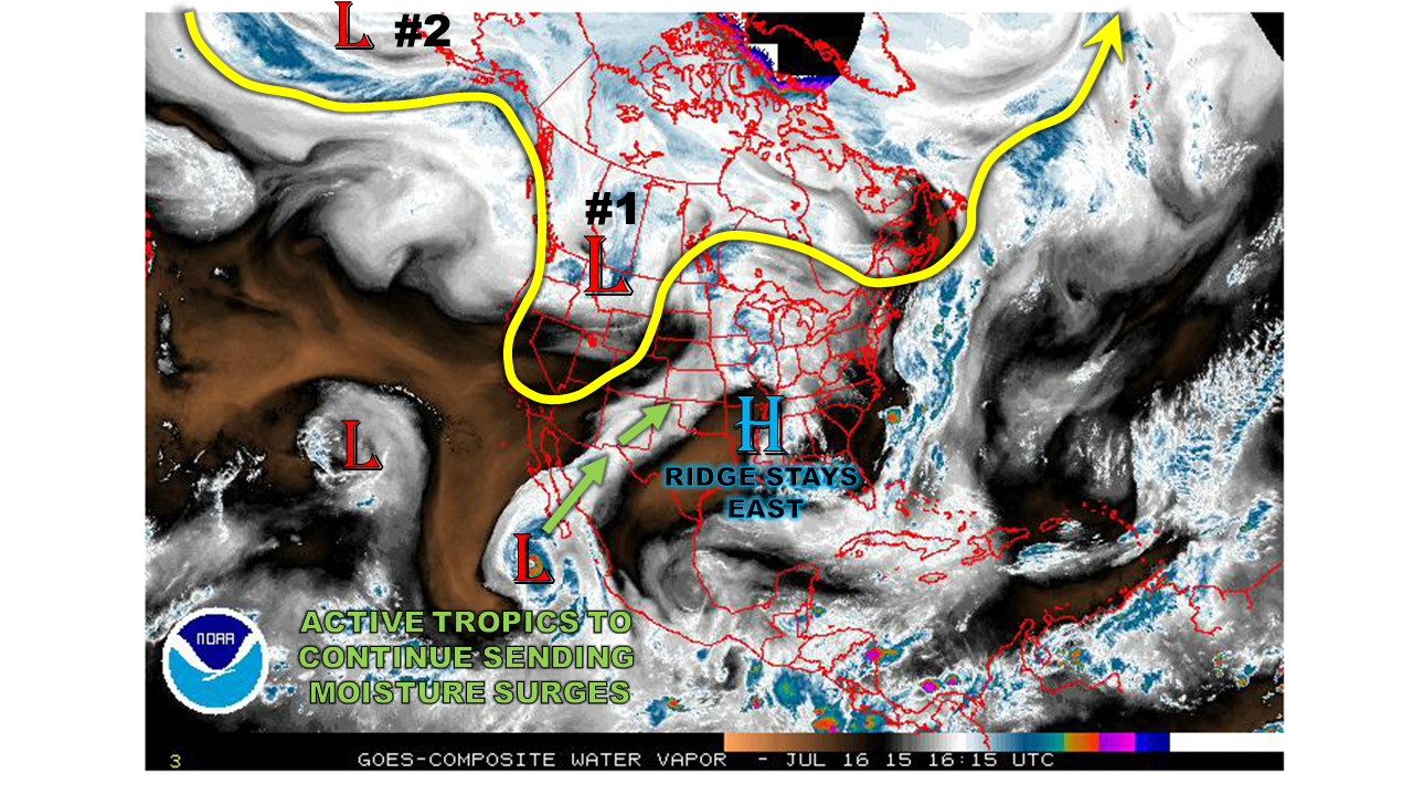
So how does this all relate to the weather over the next 15 days here at home? Two consistent signals associated with El Nino events are (i) above normal tropical cyclone activity, and (ii) more frequent disturbances across the Southwest United States. In fact, as today’s water vapor image shows, we see both. An active Pacific storm track will continue to conspire with plenty of tropical moisture to keep rainfall chances in our forecast over the next two weeks. It is interesting to note that the Eastern Pacific tropical cyclone activity is running about 3 times above normal for this time of year.
 Let’s move on to the specifics. We anticipate two organized rainfall chances over the next 15 days. The first will be caused by a strengthening disturbance currently over the west coast. Meanwhile, the second event is far across the Pacific Ocean currently, but is anticipated to arrive onto the west coast of North America late next week. Due to the high anticipated moisture content, an Elevated flood threat is issued for both events. After next weekend (starting Monday 7/27), we will likely see a few days of hot and drier weather. But in the longer range, things continue to look active for thunderstorm activity across Colorado.
Event #1: Saturday (7/18) through Monday (7/20)
An Elevated flood threat, both east and west of the Divide.
An upper-level disturbances and surface cool front will give Colorado several days of widespread thunderstorm activity starting Saturday. West of the Divide, heavy downpours will be possible, with total 3-day rainfall amounts up to 2.0 inches. East of the Divide, heavy rainfall will be a threat, along with hail and gusty winds due to an unstable atmosphere and a jet stream overhead. Although widespread flooding is not anticipated, a flash flood risk, along with mud flows and debris slides in the higher terrain, will be likely over the 3-day period.
Event #2: Thursday (7/23) – Sunday (7/26)
An Elevated flood threat mostly for the higher terrain of Central Colorado
After a few days of quieter weather, another large-scale disturbance is likely to enter the west coast of the United States. This will support another multi-day episode of heavy rainfall, this time focused over the higher terrain and west of the Divide. The rainfall threat over the Eastern Plains is not as certain at this point, because a strong high pressure ridge may press into the area. Due to a stream of tropical moisture from ongoing and developing tropical cyclone activity in the Eastern Pacific, heavy downpours will be likely over the higher terrain. A flash flood risk, as well as debris slides and mud flows will all be possible.

