Issue Date: 7/6/2015
Issue Time: 10:37 AM

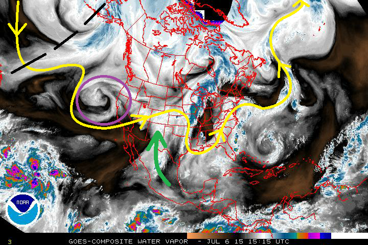
Mother Nature heard our rumblings about the upper-level ridge’s persistence, and has decided to throw a fairly active “wave train” at Colorado. This “wave train” is very visible in the water vapor image below, highlighted by the yellow line. From West to East, you can count 4-5 full waves, with the two waves upstream of Colorado being of importance to this forecast. Event #1 is the closed, upper-level low (circled in purple), and Event #2 is the upper-level trough shown by the black-dashed lines. These two large-scale disturbances will provide the focus for this 15-day period, so without further ado, let’s get right to it.
- Event #1: Tuesday (07-07-2015) through Friday (07-10-2015)
- Plenty of subtropical moisture will remain entrenched across Colorado as the approaching upper-level low (circled in purple) promotes continued moist, southwesterly flow aloft throughout the event. With the deep moisture in place, heavy rain from thunderstorms will be a significant threat. The moisture will be cut off on Saturday as the upper-level low moves east of the state.
- Event #2: Wednesday (07-15-2015) through Thursday (07-16-2015)
- Deep, subtropical moisture will overspread Colorado, once again, in the southwesterly flow ahead of the next upper-level trough (marked by the black-dashed line). The High Country will be under the gun for scattered thunderstorms producing heavy rain, and the Eastern Plains will be dealing with strong thunderstorms due to a developing lee-trough/cool front. The upper-level trough will move east of Colorado on Friday, ushering in drier air as a surface high stabilizes the atmosphere a bit.
After Event #2, upper-level ridging will take over again for a few days, but the active wave train will continue. Another upper-level trough appears poised to push through just after the 21st. Keep an eye on future FTO’s for updates on this developing situation. Mother Nature doesn’t appear ready to relax.
Tuesday (07-07-2015) through Friday (07-10-2015)
High Flood Threat As Deep, Subtropical Moisture Persists over Colorado
The approaching upper-level low will continue the transport of subtropical moisture into Colorado. Precipitable water values across the state will stay near, or above, 1 inch through the entirety of the event. The best coverage of storms, widespread at times, will be across the High Country and adjacent lower elevations. One thing is certain, heavy rain will be a threat with any thunderstorms with the sheer amount of moisture available.
Additionally, a surface dry line will develop over the Eastern Plains, bringing the threat of severe weather back to Eastern Colorado. Large hail, lightning, and strong winds will be the primary threats, but heavy rain will also be attendant.
Be sure to check back in daily with the Flood Threat Bulletin to stay up-to-date on this event.

Event #2: Wednesday (07-15-2015) through Thursday (07-16-2015)
Elevated Flood Threat Developing as Subtropical Moisture Returns
Subtropical moisture will overspread the state again, ahead of an upper-level trough. As the trough approaches and passes over the Northern Rockies, a surface low/lee-side trough will develop, transporting low-level Gulf Moisture into Eastern Colorado. This trough will become a cool front as the surface low tracks eastward across the US/Canadian border. Due to this, severe weather will be possible across the Northeast Plains, Southeast Plains, and Palmer Ridge regions.
Exacerbating the potential heavy rain issues from this event will be the widespread rainfall from Event #1. Not only will this promote unstable soils, but will also leave above-average low-level moisture across Colorado. As we have experienced already this summer, the low-level moisture has promoted several heavy rain events, especially along the Urban Corridor.