Issue Date: 7/13/2015
Issue Time: 1:55 PM

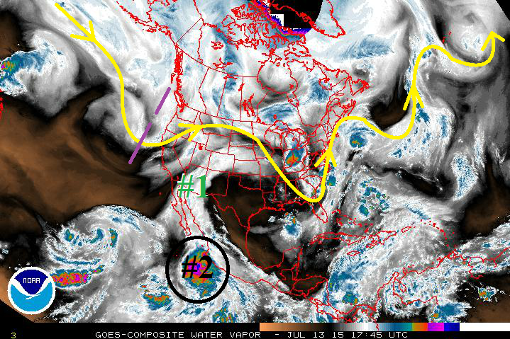
The active and wet pattern will continue for Colorado over the next 15 days as the upper-level high pressure ridge struggles to maintain its position, allowing subtropical moisture to stream in from the southwest. 2 out of 3 events during this FTO period have been placed in “Elevated Flood Threat” category, and Event #2 could be raised to a “High Flood Threat” event by Thursday’s FTO; details of this continue to come together, so stay tuned. Without further ado, here are the three events that this FTO is focused on…
- Event #1: Tuesday (07-14) through Wednesday (07-15)
- A monsoon-type impulse of subtropical moisture that began today will continue through Wednesday. Scattered thunderstorms capable of heavy rainfall are expected west of the Divide, with more isolated-to-widely scattered activity expected east of the Divide.
- Event #2: Saturday (7-18) through Monday (07-20)
- After a short break from rainfall, the upper-level high pressure will shift eastward once again, bringing moist, southwesterly flow back overhead. At the same time, Tropical Storm Dolores (circled in black on the water vapor image) will continue to intensify in the Eastern Pacific (becoming Hurricane Dolores), just off the coast of Mexico. This will usher in deeper moisture and a few weak disturbances as the storm is sheared apart by a mid-/upper-level trough deepening along the West Coast.
- Event #3: Friday (07-24) through Sunday (07-26)
- In a pattern that seems to repeat itself, the upper-level ridge over the southwestern US will shift back eastward, allowing subtropical moisture to stream into the state once again. A couple of weak disturbances will “ride the ridge” and bring a couple of days of scattered showers and thunderstorms. Event #3 is not marked on the water vapor image below; however, the general appearance of the moisture stream will look much like Event #1 marked on the image.
Event #1: Tuesday (07-14) through Wednesday (07-15)
Elevated Flood Threat as Monsoon-Type Impulse Continues
A monsoon-type impulse of subtropical moisture that began today will continue to ride northward on the western periphery of the upper-level ridge. Scattered thunderstorms capable of heavy rainfall are expected west of the Divide, which will support isolated debris slides and mud flows due to saturated soils, as well as isolated flash flooding. East of the Divide, the disturbance will cause afternoon/evening rounds of thunderstorm activity. Isolated flash flooding will be possible, mainly for urban areas where response time is quick due to impervious surfaces.

Event #2: Saturday (7-18) through Monday (07-20)
Elevated Flood Threat as Deep Moisture Lurks in the Eastern Pacific
Following Event #1, there will be a short break from rainfall as high pressure re-asserts its dominance over Colorado. Then, on Saturday, the upper-level high pressure will shift eastward in response to a deepening trough over the western US, bringing moist, southwesterly flow back overhead. At the same time, Tropical Storm/Hurricane Dolores will intensify in the Eastern Pacific, just off the coast of Mexico. This storm will likely move north-northwestward, west of the Baja California Peninsula, and the deep moisture field associated with it will likely become sheared off into the southwest flow, arriving over the weekend. Embedded with that moisture will be a couple of weak disturbances, which will likely lead to more widespread thunderstorm activity, especially over Western Colorado. Then, on Tuesday, the moisture will be briefly cut-off by the westward expansion of the upper-level high pressure. This will dry Colorado out through Thursday (07-23).
Event #3: Friday (07-24) through Sunday (07-26)
No Flood Threat Apparent
In a pattern that seems to repeat itself, the upper-level ridge over the southwestern US will shift back eastward in response to a deepening trough off over the Pacific Northwest, allowing subtropical moisture to stream into the state, once again. A couple of weak disturbances will “ride the ridge” and bring a couple of days of scattered showers and thunderstorms. The depth of the moisture available is still uncertain, so no flood threat is apparent at this time.
As quickly as it began it will end again, as the upper-level ridge shifts back westward on Monday, drying Colorado out for the remainder of this FTO period.