FTO 09-10-2015: Elevated Flood Threat Makes an Appearance for Event #2

Issue Date: 9/10/2015
Issue Time: 12:20 PM

Threat_Timeline_20150910

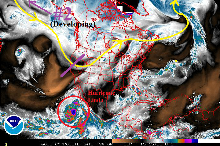
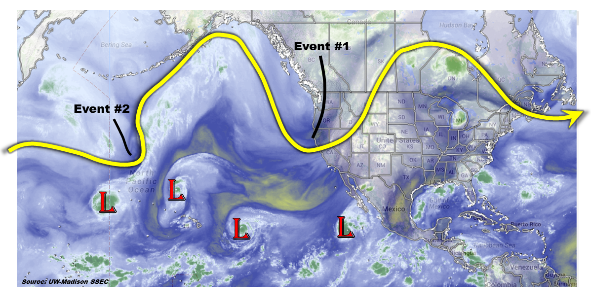
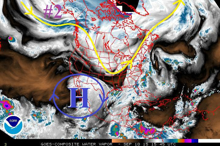
There are three rain events in this edition of the FTO, but only one shows any resemblance to a developing flood threat. Event #1 will be the result of a weak, surface cool front trailing southward behind a surface Low shifting across the northern US. This will bring an increase of clouds to the Urban Corridor and eastward, but rainfall chances will be mainly confined to the Southeast Mountains, Raton Ridge, and portions of the Southeast Plains. The cool front’s effects will be too shallow to bring much changes to the High Country, leaving those areas with mostly sunny skies and dry conditions. Event #2 (marked by purple “#2” in water vapor image below) will have effects from a mid-/upper-level disturbance and an associated surface cool front. This is the “event to watch” for this FTO period, as it appears moisture will make a good rebound with southwesterly flow aloft ahead of the approaching disturbance, and enhanced large-scale support for showers and thunderstorms with the disturbance.

20150910_WV

After a short break, Event #3 will kick off Friday afternoon and last through Monday. Model guidance continues to flip-flop, and confidence is low in the amount of moisture available and potential precipitation. Stay tuned for the Monday FTO for another look at this event.

Event #1: Friday (09-11-2015)

No Apparent Flood Threat

A weak, surface cool front will be dragged across Colorado by a surface low pressure system translating eastward across the US/Canadian border late Thursday. Behind the cool front, upslope flow will develop, resulting in an increase of clouds for areas east of the mountains. Moisture will be lacking as it is suppressed south by high pressure aloft (blue “H”), and no flood threat will materialize. The best chance for rain will be along the Southeast Mountains, Raton Ridge, and portions of the Southeast Plains, and rainfall accumulation will be less than 0.5 inches for all locations.

Legend

Event #2: Monday (09-14-2015) through Wednesday (09-16-2015)

Another Cool Front, Elevated Flood Threat Developing

A mid-/upper-level shortwace disturbance will work across the northern US states, pushing a surface cool front through Colorado and pulling low-level Gulf Moisture into eastern Colorado. Ahead of the disturbance, southwesterly flow aloft will increase, bringing a nice surge of mid-level monsoonal moisture, as well. Combining with the increase in moisture, large-scale support for showers and thunderstorms will increase with this shortwave, thus the introduction of the “Elevated Flood Threat” category. The best rain will fall across western Colorado, especially the Grand Valley, Southwest Slope, and San Juan Mountain Regions.

Legend

Event #3: Friday (09-18-2015) through Monday (09-21-2015)

No Apparent Flood Threat, but System Bears Watching as Models Continue to Flip-Flop

Long-range guidance continues to flip-flop on what they expect to happen with this event. Confidence that there will be a rain event in this timeframe has risen while confidence on the amount of moisture/instability available, and thus precipitation, continues to be very low. We will keep an eye on this event as we move forward, but at this time no precipitation map is warranted.

FTO 09-07-2015: Two Events, No Apparent Flood Threats

Issue Date: 9/7/2015
Issue Time: 12:22 PM

Threat_Timeline_09072015

Keeping with the theme of the previous FTO, there will be two rain events, but no flood threat is apparent with either. This is not unusual for September, as moisture values are on a climatological downward trend. Visually, the climatological precipitable water curves shows this trend nicely (September highlighted by green rectangle):

DNR_ClimoGJT_Climo

Aside from relatively lacking moisture, significant upper-level disturbances are going to be hard to come by for this FTO period. Event #1 will be the result of a weak, surface cool front trailing southward behind a surface Low shifting across the northern US. Ahead of the cool front, Gulf moisture will be pulled into eastern Colorado, and northwesterly flow aloft will provide shear to organize storms. With the higher threshold for flooding to develop on the plains, no flood threat can be identified at this time. This system will bear watching as the weekend draws nearer.
Event #2 will have effects from a mid-level disturbance and an associated surface cool front. Moisture does not appear to be sufficient enough to warrant a flood threat, and showers and garden-variety thunderstorms will be the main result. Late summer rains are always welcome, and this event will be no different. For more details, see the individual discussions below.

09072015_WV

Event #1: Friday (09-11-2015) and Saturday (09-12-2015)

No Apparent Flood Threat, but the Event Bears Monitoring

A weak, surface cool front will be dragged across Colorado by a surface low pressure system translating eastward across the US/Canadian border. Ahead of the front, Gulf moisture will be pulled into eastern Colorado, pushing precipitable water values to at, or just above, 1 inch along the CO/KS border. Decent instability and northwesterly flow aloft will perhaps bring about a slight severe wind/hail threat. This will bear watching as the weekend draws nearer.

Legend

Event #2: Tuesday (09-15-2015) through Thursday (09-17-2015)

Another Cool Front, but No Apparent Flood Threat as Moisture is Still in Question

A mid-level disturbance with its origins west of Alaska will finally work across the northern US states, pushing a surface cool front through Colorado. Ahead of this frontal boundary, it is unclear how much surface moisture will increase. However, with east-southeasterly flow ahead of the front, an increase in moisture is likely. This will need to be monitored over the next week. Current observations/guidance suggest precipitable water values will remain below 1 inch in areas where storms are expected, and the map below echoes this current thinking.

Legend

FTO 09-03-2015: A Few Rain Events, But No Flood Threat Noted

Issue Date: 9/3/2015
Issue Time: 1:00PM
Valid Dates: 9/4 – 9/18

Overview

threat_timeline_20150903The water vapor image, below, shows quite an amplified pattern with two distinct ridge-trough couplets extending across North America and into the Pacific. Such patterns can indicate active weather, but does not necessarily translate to a heavy rainfall threat across Colorado. Meanwhile, in the subtropical Pacific Ocean, there are four, that’s right, four separate tropical disturbances: three of these are hurricanes and one is a tropical storm. In fact, Dr. Phil Klotzbach from Colorado State University points out that 2015 is now the most active east Pacific hurricane season on record:

However, the impact of east Pacific hurricanes can be hit or miss on Colorado. Over this Flood Threat Outlook period, there will only be minimal impact in form of some moisture return early in the forecast period.watervapor_20150903We anticipate two precipitation events to impact Colorado over the next 15 days. The first will occur Friday into Saturday (9/4-9/5), mainly the result of a large-scale trough entering the west coast of North America. Although the trough will receive some help from subtropical moisture return, moderate to strong steering winds and limited instability will limit the heavy rainfall threat. A quiet period will ensue for early next week. Then, a cool front will drape southward across the Northern and Central Plains. However, the only impact on Colorado appears to be some light to moderate rainfall (no flood threat expected) mid next week. During week 2, there is significant disagreement in guidance but, in general, there is little to no indication of a heavy rainfall threat across the state. Instead, there will be chances of rainfall with frontal passages that will provide for widespread light to moderate rainfall amounts. This rainfall will be welcome.

Event #1: Friday (9/4) – Saturday (9/5)

No Apparent Flood Threat

A large scale trough will be aided by subtropical moisture resulting in shower and thunderstorm activity across mostly western Colorado on Friday and Saturday. Over the course of the period, up to 1.5 inches of rainfall will be possible in the San Juans and Central Mountains. However, due to fast steering winds, heavy rainfall is not expected. Additional rainfall, in the 0.5 to 0.75 inch range may occur over the Northeast Plains on Saturday as the disturbance moves away.


Legend

Event #2: Wednesday (9/9)

No Apparent Flood Threat

A cool front will quickly race southward across Colorado on Tuesday/Wednesday and then stall over the Southeast Plains. There will be upslope flow, but instability and moisture will be very marginal for heavy rainfall. Instead, we anticipate shower activity, with perhaps an isolated thunderstorm across the Southeast Plains Wednesday. Highest rainfall amounts will be limited to about 0.5 – 0.75 inches.


Legend

FTO 08-31-2015: Three Events, One Elevated Flood Threat On Tap

Issue Date: 8/31/2015
Issue Time: 12:40 PM

Threat_Timeline_20150831

True to form, the first thing to do when discussing the 15-day forecast is to take a look at the water vapor imagery and analyze the current workings of the atmosphere. First of all, the central Pacific Ocean remains active with three hurricanes (two pictured, circled in red; Ignacio left, Jimena right). While bearing no direct effects to Colorado, you can see the moisture connection between Ignacio and Colorado, as southwest flow aloft transports the moisture into the SW United States. The purple line represents the trough that will spend the better part of this week/weekend digging along the west coast. This will keep persistent southwest flow aloft across Colorado, maintaining the same sort of pattern that we have experienced over the previous 4 or so days. Moisture will gradually decrease Tuesday through Thursday, before increasing again on Friday and into the weekend. The drying will help break up the forecast between Events #1 and #2.

08312015_WV

By the end of the weekend/early next week, the upper-trough will push to the east, bringing an end to the persistent southwest flow and monsoonal moisture for a day or so. Then, almost like clockwork, another upper-level trough will enter the Pacific NW, placing Colorado under the influence of southwest flow once again. This trough will be a bit more transient than previous iterations, only bringing a two-day wet period before moving on and allowing Colorado to dry out for a few days to end this forecast period.

A LOOK AHEAD: After this 15-day period, the effects of the three hurricanes in the central Pacific will become more direct through indirect means; their recurving into the storm track across the northern Pacific will hold ramifications for our weather pattern. A favorable recurve/wave interaction could lead to another active period, but this is purely speculative at this point. It is way too early to tell, so be sure and stay tuned.

Event #1: Tuesday (09-01-2015)

No Apparent Flood Threat during Final Day of the Current Moisture Surge

Southwest flow aloft will remain over Colorado on Tuesday, combining with the lingering moisture plume to bring about another day of scattered showers/thunderstorms over the mountains and isolated coverage elsewhere. Instability values will spend another day on the low side, unable to unlock the full potential of the monsoonal moisture. For that reason, no apparent flood threat exists at this time. Depending on how today (08-31-2015) unfolds with respect to rainfall totals/saturated soil, a low flood threat may be introduced in tomorrow’s FTB. Be sure and check back in tomorrow morning for the latest.

Legend

Event #2: Thursday (09-03-2015) through Sunday (09-06-2015)

Elevated Flood Threat with a Near-Repeat Performance but an Additional Co-Star

Persistent southwest flow aloft will once again be the name of the game, bringing monsoonal moisture/disturbances into Colorado. The pattern is a near-repeat of the past 4 or so days, but an additional player will throw its hat in the ring; Tropical Storm Kevin. It has not been named yet, but will be in the next 24-48 hours. The remnants of Kevin will be pulled northward in the southwest flow, reaching Colorado by Saturday/Sunday. This extra moisture/associated disturbance will bring scattered-to-widespread showers/thunderstorms capable of heavy rainfall. By Sunday Night/Monday morning, the upper-level trough will push eastward, bringing the persistent southwest flow to an end for a day or so.

Legend

Event #3: Tuesday (09-08-2015) and Wednesday (09-09-2015)

No Apparent Flood Threat as This Event is Still Coming into Focus

As discussed above and in the previous FTO, Event #3 will be a quick-hitter. The upper-level trough will push to the east in a fairly quick fashion, bringing a short period of moisture and favorable dynamics for scattered-to-widespread precipitation. At this time, though, it appears the best large-scale support may remain north of Colorado, so the upcoming days will hold a lot of insight into how this event will ultimately play out. Please check back in the next edition of the FTO on Thursday for updated information.