Issue Date: 9/10/2015
Issue Time: 12:20 PM
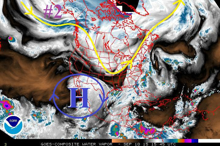
There are three rain events in this edition of the FTO, but only one shows any resemblance to a developing flood threat. Event #1 will be the result of a weak, surface cool front trailing southward behind a surface Low shifting across the northern US. This will bring an increase of clouds to the Urban Corridor and eastward, but rainfall chances will be mainly confined to the Southeast Mountains, Raton Ridge, and portions of the Southeast Plains. The cool front’s effects will be too shallow to bring much changes to the High Country, leaving those areas with mostly sunny skies and dry conditions. Event #2 (marked by purple “#2” in water vapor image below) will have effects from a mid-/upper-level disturbance and an associated surface cool front. This is the “event to watch” for this FTO period, as it appears moisture will make a good rebound with southwesterly flow aloft ahead of the approaching disturbance, and enhanced large-scale support for showers and thunderstorms with the disturbance.
After a short break, Event #3 will kick off Friday afternoon and last through Monday. Model guidance continues to flip-flop, and confidence is low in the amount of moisture available and potential precipitation. Stay tuned for the Monday FTO for another look at this event.
Event #1: Friday (09-11-2015)
No Apparent Flood Threat
A weak, surface cool front will be dragged across Colorado by a surface low pressure system translating eastward across the US/Canadian border late Thursday. Behind the cool front, upslope flow will develop, resulting in an increase of clouds for areas east of the mountains. Moisture will be lacking as it is suppressed south by high pressure aloft (blue “H”), and no flood threat will materialize. The best chance for rain will be along the Southeast Mountains, Raton Ridge, and portions of the Southeast Plains, and rainfall accumulation will be less than 0.5 inches for all locations.
Event #2: Monday (09-14-2015) through Wednesday (09-16-2015)
Another Cool Front, Elevated Flood Threat Developing
A mid-/upper-level shortwace disturbance will work across the northern US states, pushing a surface cool front through Colorado and pulling low-level Gulf Moisture into eastern Colorado. Ahead of the disturbance, southwesterly flow aloft will increase, bringing a nice surge of mid-level monsoonal moisture, as well. Combining with the increase in moisture, large-scale support for showers and thunderstorms will increase with this shortwave, thus the introduction of the “Elevated Flood Threat” category. The best rain will fall across western Colorado, especially the Grand Valley, Southwest Slope, and San Juan Mountain Regions.
Event #3: Friday (09-18-2015) through Monday (09-21-2015)
No Apparent Flood Threat, but System Bears Watching as Models Continue to Flip-Flop
Long-range guidance continues to flip-flop on what they expect to happen with this event. Confidence that there will be a rain event in this timeframe has risen while confidence on the amount of moisture/instability available, and thus precipitation, continues to be very low. We will keep an eye on this event as we move forward, but at this time no precipitation map is warranted.


