Issue Date: 9/7/2015
Issue Time: 12:22 PM

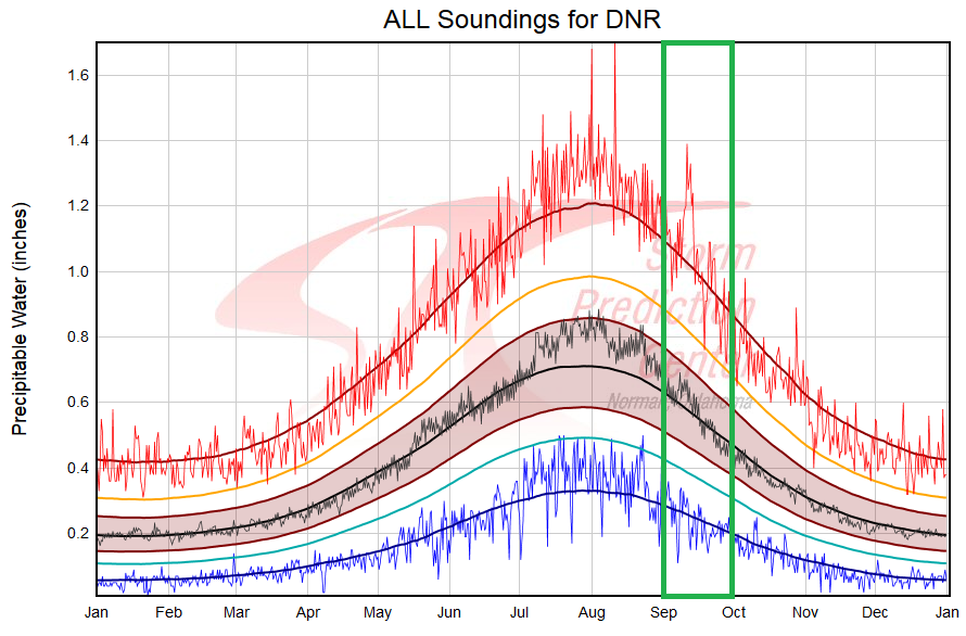
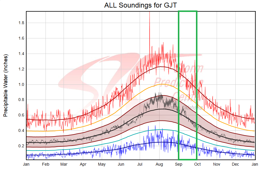
Keeping with the theme of the previous FTO, there will be two rain events, but no flood threat is apparent with either. This is not unusual for September, as moisture values are on a climatological downward trend. Visually, the climatological precipitable water curves shows this trend nicely (September highlighted by green rectangle):
Aside from relatively lacking moisture, significant upper-level disturbances are going to be hard to come by for this FTO period. Event #1 will be the result of a weak, surface cool front trailing southward behind a surface Low shifting across the northern US. Ahead of the cool front, Gulf moisture will be pulled into eastern Colorado, and northwesterly flow aloft will provide shear to organize storms. With the higher threshold for flooding to develop on the plains, no flood threat can be identified at this time. This system will bear watching as the weekend draws nearer.
Event #2 will have effects from a mid-level disturbance and an associated surface cool front. Moisture does not appear to be sufficient enough to warrant a flood threat, and showers and garden-variety thunderstorms will be the main result. Late summer rains are always welcome, and this event will be no different. For more details, see the individual discussions below.
Event #1: Friday (09-11-2015) and Saturday (09-12-2015)
No Apparent Flood Threat, but the Event Bears Monitoring
A weak, surface cool front will be dragged across Colorado by a surface low pressure system translating eastward across the US/Canadian border. Ahead of the front, Gulf moisture will be pulled into eastern Colorado, pushing precipitable water values to at, or just above, 1 inch along the CO/KS border. Decent instability and northwesterly flow aloft will perhaps bring about a slight severe wind/hail threat. This will bear watching as the weekend draws nearer.

Event #2: Tuesday (09-15-2015) through Thursday (09-17-2015)
Another Cool Front, but No Apparent Flood Threat as Moisture is Still in Question
A mid-level disturbance with its origins west of Alaska will finally work across the northern US states, pushing a surface cool front through Colorado. Ahead of this frontal boundary, it is unclear how much surface moisture will increase. However, with east-southeasterly flow ahead of the front, an increase in moisture is likely. This will need to be monitored over the next week. Current observations/guidance suggest precipitable water values will remain below 1 inch in areas where storms are expected, and the map below echoes this current thinking.