Issue Date: 9/3/2015
Issue Time: 1:00PM
Valid Dates: 9/4 – 9/18
Overview
 The water vapor image, below, shows quite an amplified pattern with two distinct ridge-trough couplets extending across North America and into the Pacific. Such patterns can indicate active weather, but does not necessarily translate to a heavy rainfall threat across Colorado. Meanwhile, in the subtropical Pacific Ocean, there are four, that’s right, four separate tropical disturbances: three of these are hurricanes and one is a tropical storm. In fact, Dr. Phil Klotzbach from Colorado State University points out that 2015 is now the most active east Pacific hurricane season on record:
Thru Sep. 3, the NE Pacific (to 180W) has had more major hurricane days in 2015 than any other year on record. pic.twitter.com/DaG7lx9KFk
— Philip Klotzbach (@philklotzbach) September 3, 2015
However, the impact of east Pacific hurricanes can be hit or miss on Colorado. Over this Flood Threat Outlook period, there will only be minimal impact in form of some moisture return early in the forecast period.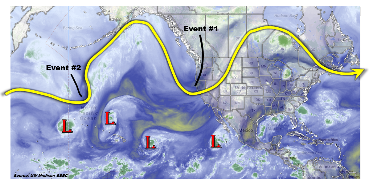 We anticipate two precipitation events to impact Colorado over the next 15 days. The first will occur Friday into Saturday (9/4-9/5), mainly the result of a large-scale trough entering the west coast of North America. Although the trough will receive some help from subtropical moisture return, moderate to strong steering winds and limited instability will limit the heavy rainfall threat. A quiet period will ensue for early next week. Then, a cool front will drape southward across the Northern and Central Plains. However, the only impact on Colorado appears to be some light to moderate rainfall (no flood threat expected) mid next week. During week 2, there is significant disagreement in guidance but, in general, there is little to no indication of a heavy rainfall threat across the state. Instead, there will be chances of rainfall with frontal passages that will provide for widespread light to moderate rainfall amounts. This rainfall will be welcome.
Event #1: Friday (9/4) – Saturday (9/5)
No Apparent Flood Threat
A large scale trough will be aided by subtropical moisture resulting in shower and thunderstorm activity across mostly western Colorado on Friday and Saturday. Over the course of the period, up to 1.5 inches of rainfall will be possible in the San Juans and Central Mountains. However, due to fast steering winds, heavy rainfall is not expected. Additional rainfall, in the 0.5 to 0.75 inch range may occur over the Northeast Plains on Saturday as the disturbance moves away.

Event #2: Wednesday (9/9)
No Apparent Flood Threat
A cool front will quickly race southward across Colorado on Tuesday/Wednesday and then stall over the Southeast Plains. There will be upslope flow, but instability and moisture will be very marginal for heavy rainfall. Instead, we anticipate shower activity, with perhaps an isolated thunderstorm across the Southeast Plains Wednesday. Highest rainfall amounts will be limited to about 0.5 – 0.75 inches.