Issue Date: 8/31/2015
Issue Time: 12:40 PM

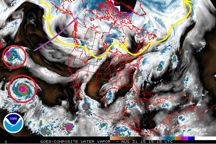
True to form, the first thing to do when discussing the 15-day forecast is to take a look at the water vapor imagery and analyze the current workings of the atmosphere. First of all, the central Pacific Ocean remains active with three hurricanes (two pictured, circled in red; Ignacio left, Jimena right). While bearing no direct effects to Colorado, you can see the moisture connection between Ignacio and Colorado, as southwest flow aloft transports the moisture into the SW United States. The purple line represents the trough that will spend the better part of this week/weekend digging along the west coast. This will keep persistent southwest flow aloft across Colorado, maintaining the same sort of pattern that we have experienced over the previous 4 or so days. Moisture will gradually decrease Tuesday through Thursday, before increasing again on Friday and into the weekend. The drying will help break up the forecast between Events #1 and #2.
By the end of the weekend/early next week, the upper-trough will push to the east, bringing an end to the persistent southwest flow and monsoonal moisture for a day or so. Then, almost like clockwork, another upper-level trough will enter the Pacific NW, placing Colorado under the influence of southwest flow once again. This trough will be a bit more transient than previous iterations, only bringing a two-day wet period before moving on and allowing Colorado to dry out for a few days to end this forecast period.
A LOOK AHEAD: After this 15-day period, the effects of the three hurricanes in the central Pacific will become more direct through indirect means; their recurving into the storm track across the northern Pacific will hold ramifications for our weather pattern. A favorable recurve/wave interaction could lead to another active period, but this is purely speculative at this point. It is way too early to tell, so be sure and stay tuned.
Event #1: Tuesday (09-01-2015)
No Apparent Flood Threat during Final Day of the Current Moisture Surge
Southwest flow aloft will remain over Colorado on Tuesday, combining with the lingering moisture plume to bring about another day of scattered showers/thunderstorms over the mountains and isolated coverage elsewhere. Instability values will spend another day on the low side, unable to unlock the full potential of the monsoonal moisture. For that reason, no apparent flood threat exists at this time. Depending on how today (08-31-2015) unfolds with respect to rainfall totals/saturated soil, a low flood threat may be introduced in tomorrow’s FTB. Be sure and check back in tomorrow morning for the latest.

Event #2: Thursday (09-03-2015) through Sunday (09-06-2015)
Elevated Flood Threat with a Near-Repeat Performance but an Additional Co-Star
Persistent southwest flow aloft will once again be the name of the game, bringing monsoonal moisture/disturbances into Colorado. The pattern is a near-repeat of the past 4 or so days, but an additional player will throw its hat in the ring; Tropical Storm Kevin. It has not been named yet, but will be in the next 24-48 hours. The remnants of Kevin will be pulled northward in the southwest flow, reaching Colorado by Saturday/Sunday. This extra moisture/associated disturbance will bring scattered-to-widespread showers/thunderstorms capable of heavy rainfall. By Sunday Night/Monday morning, the upper-level trough will push eastward, bringing the persistent southwest flow to an end for a day or so.
Event #3: Tuesday (09-08-2015) and Wednesday (09-09-2015)
No Apparent Flood Threat as This Event is Still Coming into Focus
As discussed above and in the previous FTO, Event #3 will be a quick-hitter. The upper-level trough will push to the east in a fairly quick fashion, bringing a short period of moisture and favorable dynamics for scattered-to-widespread precipitation. At this time, though, it appears the best large-scale support may remain north of Colorado, so the upcoming days will hold a lot of insight into how this event will ultimately play out. Please check back in the next edition of the FTO on Thursday for updated information.