FTO 05-05-2016: Two Events, One Elevated Flood Threat

Issue Date: 5/05/2016
Issue Time: 1:30 PM

Threat_Timeline_20160505

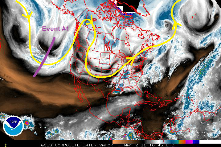
Taking a look at the water vapor image below, the two major players during this FTO period nearly jump off the page. In general, the upper-level pattern is highly amplified, characterized by troughing over the eastern US, ridging over the west-central US, and troughing across the western US (with the upper-level low centered just offshore). This highly amplified pattern will keep things moving slowly, and thus will result in an extended cool, wet period (Event #1) as the upper-level low (denoted by purple “#1”) moves inland and across the region. Event #1 carries with it an elevated flood threat, mainly due to increasing snow melt coinciding with the wet period. Additionally, strong-to-severe storms are possible on Friday/Saturday across northern and northeastern CO, which could be attended by heavier rain rates, depending on how much moisture is available. Those details are best left to the FTB, so stay tuned.

WV_20160505

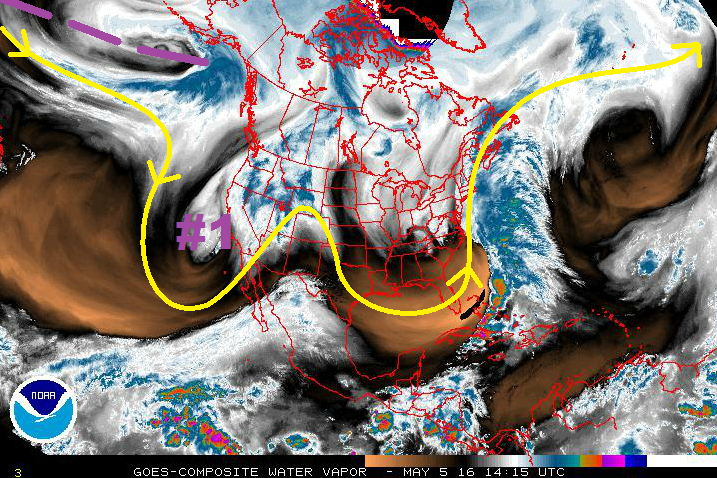
After Event #1, ridging is expected to build across the western US, bringing a drying and warming trend with it back to Colorado. Confidence remains low on how long the ridging will last thanks to this flow regime and the difficulties that come with it. Underneath this ridging, it is important to note that temperatures will warm and increase snow melt. Streamflows will really begin to rise relatively quickly, especially through the High Country, and eventually in the lower elevations.

At this time, it appears the ridging will shift east of Colorado by Sunday/Monday (15th/16th) in advance of the next upper-level trough (marked by the purple dashed line). This upper-level trough (Event #2) is not in a particular hurry to get here, and its details will continue coming into focus over the coming days. No apparent flood threat can be distinguished at this current time.

Friday (05-06-2016) through Wednesday (05-11-2016)

Elevated Flood Threat with Extended Wet Period, Snow Melt, Strong-to-Severe Thunderstorms

For Friday, south-southwest flow aloft will continue across the state, and lift ahead of the upper-level trough will produce scattered showers/thunderstorms across the mountains. For the plains, moisture will be a bit limited overall, except north of a frontal boundary creeping in to northeast Colorado. On the drier/southern side of the frontal boundary thunderstorms will be isolated, and a bit more scattered on the moist/northern side of the boundary. On the dry side of the boundary, including the San Luis Valley, fire conditions will be elevated.

The surface low will continue to deepen on Saturday east of the mountains, with flow around it transporting in better moisture from the south/southeast. A dryline will arc southward from the low, and the other frontal boundary will extend eastward across the Palmer Ridge and onto the plains. Meanwhile, in the mid-levels, a disturbance will rotate overhead. All of these factors together bring the risk for strong-to-severe thunderstorms across eastern Colorado for Saturday. These storms will be bring the threat of heavy rain, in which street/field ponding will be the main flooding concern. Scattered High Country showers/thunderstorms are also expected.

For Sunday-Wednesday, the backside of the upper-level low will bring cool, northwesterly flow to Colorado, wrapping moisture back around into the state. Cool air aloft will allow for a few showers and thunderstorms to develop, mainly across the northern half of the state.

Legend

Event #2: Monday (05-16-2016) through Thursday (05-19-2015)

No Apparent Flood Threat

Event #2 is still coming into focus, and we are a few days away from honing in on this particular feature. At this time, it appears the upper-level trough associated with this event will take its time coming onshore and making its way towards Colorado. There are indications that the “slow” regime that we are currently encapsulated by will break down by the middle part of next week, and this upper-level trough will move quicker across the region than that of Event #1. The amount of moisture/instability available, the length of wet period, etc. are still to be determined, and thus no apparent flood threat. Due to this uncertain nature, no precipitation map will be produced. Stay tuned to the next FTO on Monday for another look at this event period.

FTO 05-02-2016: One Event on the Horizon, No Flood Threat Apparent

Issue Date: 5/02/2016
Issue Time: 1:15 PM

Threat_Timeline_20160502

Welcome back to the 2016 Season of the Flood Threat Outlook. After last year’s summer of statewide drought-busting, we look forward to another year of the same, and maintenance of non-drought conditions. So, to start off this season, let’s take a look at our initial background conditions (as of April 26, 2016):

DroughtMonitor_20160502

Nearly 75% of the state of Colorado is drought free, while just over 23% is in the abnormally dry (bright yellow) category. However, this past week’s rain/snow is not incorporated into this analysis (it will be in the update on Thursday), so it is likely that the abnormally dry area has shrunk in size. 2% of the state is in the moderate drought category (light brown), which includes portions of Prowers, Bent, Baca, and Las Animas counties. Overall, this is a stark difference from just one year ago, when nearly 36% of the state was under severe drought conditions.

As for El Nino, it has begun to wane. Take a look at the latest SST Anomaly analysis from NOAA/NESDIS below, and notice that each El Nino region has cool anomalies beginning to appear as cooling continues. This indicates the transition to a more neutral phase, albeit still slightly warm. Below the surface, the cool water waits, and the warm top layer is eroding. Most ensembles indicate a transition to La Nina in short order, with several members of those models indicating a moderate La Nina taking shape by Fall.

SST_Anomaly

With all of that said, I do not expect the waning El Nino, or appearing La Nina to have any major impacts on Colorado during the 2016 FTO Season. Our antecedent conditions show plenty of moisture available within the soil for summertime thunderstorms, and ensembles hint at slightly above average precipitation during May and June before more “average” conditions take hold for the remainder of the season. Couple those thoughts with the fact that Texas has generally been wet during the last few months, and dry conditions typical of a La Nina will be slow to emerge this season, if at all.

Without any further ado, let’s jump right into the FTO forecast at hand. Taking a look at the water vapor image below, it’s fairly easy to pick out the major players in the first half of this FTO period. First of all, the upper-level ridge that is building over the western US will be in place for the next few days, as the eastward progression is slowed by the amplified atmospheric flow regime. The ridge will finally shift of east of the state by Thursday as the upper-level trough (marked by “Event #1”) moves onshore over California, opening up another wet, cool period for Colorado May 5th – May 8th.

WV_20160502

After Event #1, ridging is expected to build across the western US, but confidence is low on how long that will last. At this time, it appears that it will continue until next Thursday-Saturday (12th-14th), before breaking down as an upper-level shortwave trough slides across the region at the end of this FTO period. A shortwave trough that time of year usually presents a chance for stronger thunderstorms and severe weather, especially across the eastern plains. This time period will be important to monitor, and will be re-examined on Thursday’s FTO.

Event #1: Thursday (05-05-2016) through Sunday (05-08-2015)

Upper-Level Low Brings Cool, Wet Period, but No Apparent Flood Threat

As the upper-level trough comes onshore over California, and pushes the ridge east over the central US, south-southwest flow aloft will overspread Colorado. This will increase the mid-level moisture, especially over the higher terrain, which will allow for afternoon convection across the High Country. The lower elevations east of the mountains will likely stay dry on Thursday with afternoon highs near 80 F.

For Friday, south-southwest flow aloft will continue across the state, while a surface low will deepen east of the mountains. The flow around the surface low will transport in better moisture from the south/southeast, and instability will climb. A few stronger storms are possible over the Northeast and Southeast Plains, and perhaps back into the Palmer Ridge and Urban Corridor regions. Garden variety showers and thunderstorms will also be present across the High Country.

On Saturday, scattered showers thunderstorms are likely in the mountains. Out east over the lower elevations, the result is much less certain. Underneath the large scale flow regime that currently exists across the US, predictability is limited in the medium range. There are two scenarios that could unfold:

  1. The upper-level low is slower to push to the east, leaving the surface low/dryline in favorable position for strong-to-severe storms across eastern Colorado on Saturday
  2. The upper-level low pushes out quicker than expected, and the surface low/dryline are positioned over Kansas, leaving eastern Colorado generally dry and breezy.

For Sunday, the backside of the upper-level low will bring cool, northwesterly flow to Colorado. Cool air aloft will allow for a few showers and thunderstorms across the state, but rain rates will remain below flash flood thresholds.
Due to uncertainty with the evolution of the upper-level low, and the amount of moisture available, no flood threat is apparent. At this time, it appears that rain rates will remain below flash flood thresholds. Stay tuned for updates in Thursday’s FTO.

Legend

FTO 09-28-2015: 2016 Snowpack Forecast

Issue Date: 9/28/2015
Issue Time: 4:30PM

*If you are looking for the Flood Threat Outlook, please scroll down to the next post.

Due to the extreme importance of the winter snowpack for our water supply, we decided to end the Flood Threat Bulletin season (our daily product ends on 9/30, while today is the last Flood Threat Outlook) with a special seasonal snowpack forecast for the state. Before we begin to discuss our findings, a disclaimer is in order: this is NOT an official forecast! It is simply our estimate of what we think this winter will bring.

What are we predicting?

One of the most useful variables for water supply planning is the Snow Water Equivalent. But even more specifically, the maximum Snow Water Equivalent (hereafter, SWEmax), which generally occurs from March to early June. Because the SWEmax usually varies, sometimes significantly, across Colorado, we decided to split the state up into seven snowpack “regions”. These regions were established using watershed boundaries. The table below shows these regions as well as the 2 or 3 SNOTEL snow gauges that were used to characterize each basin. We only use gauges with 35+ years of data, in order to ensure a robust signal.

regions_table

What do we use as predictors?

Our experience shows that forecasting streamflow and snowpack several months in advance requires a thorough analysis of large-scale atmospheric and oceanic conditions across the globe. These conditions are quantified through what we refer to as Hydro-Climate Indices (HCIs), which include commonly heard HCIs such as the El Nino-Southern Oscillation (ENSO) index, the Palmer Drought Severity Index (PDSI) and the Arctic Oscillation along with many others. Knowledge of the state of HCIs is important because they exert a large influence on weather patterns even far from their “home region”. For example, ENSO is defined using tropical Pacific SSTs, but can significantly influence precipitation patterns in Indonesia, Brazil and even the southeastern United States. Our experience suggests that ENSO and the PDSI are especially useful for long-range forecasting in Colorado. Thus, we will use these two indices as predictors. In addition, we will use the time rates of change, or tendencies, of these indices. For example, the ENSO tendency is currently strongly positive since El Nino conditions are developing (it would be negative if La Nina conditions are developing). Also, just to clarify, the term “ENSO” implicitly includes within it both El Nino and La Nina events.

Assembling the forecast ingredients

We began by looking at our two predictors. The figure below shows global sea-surface temperature anomalies. The region of importance is shown in the black box. Note the very strongly positive anomalies that characterize the moderate/strong El Nino event that we are currently experiencing. Through an anomalously active subtropical storm track, El Nino typically results in much higher than normal precipitation in Southern California and the southwest U.S. However, its impact on Colorado is limited to the southwest part of our state.

NOAA_OISSTNext, the chart below shows that sea-surface temperatures in the so-called NINO3.4 region (a way of measure the ENSO strength) have been steadily warming over the last 3-6 months. This is important, because unlike ENSO itself, a positive tendency in ENSO is associated with below normal snowpack across most of Colorado. Thus, the combination of a positive ENSO + positive ENSO tendency can result in a cancellation of either signal.

Nino3.4

The next predictor we looked at was PDSI, and its tendency. The maps below show PDSI values across the western United States during April and August. Due to an incredibly wet spring/early summer, most of eastern Colorado has positive PDSI values. Meanwhile, it is clear that the PDSI tendency over the past ~6 months has also been positive across most of the southwest United States and the Rocky Mountain states. For example, look at southern Utah and northern Arizona. Due to land-atmosphere feedbacks, both positive PDSI and positive PDSI tendency suggest above normal snowpack across most of Colorado.

 PDSI_april_august2016 SWEmax Forecast

After building forecast models for each of our seven snowpack regions, we now present our 2016 SWEmax forecast in the map below. We present the results as a percentage of normal.

SWE_forecast_mapThe North Platte and Gunnison basins are expected to see below normal SWEmax, while the South Platte basin is near normal. Meanwhile, above average SWEmax is expected in the Arkansas, Colorado/Yampa/White and Dolores basins.

A few other important issues:

  • Note that the Rio Grande basin does not have a forecast. We could find any significant skill here using our four predictor variables. This is not entirely unexpected given the closed-in nature of the basin, which makes it less amenable to long-range predictions using the HCI methodology.
  • Note that the North Platte and South Platte forecast numbers are italicized. This indicates that those forecasts have low confidence. However, low confidence is better than no confidence (as was the case for the Rio Grande).

FTO: Final FTO of the Season, Two Events in the First Six Days

Issue Date: 9/28/2015
Issue Time: 12:27 PM

**THIS IS THE FINAL FLOOD THREAT OUTLOOK OF THE 2015 SEASON. WE WILL POST AN ADDITIONAL SNOWPACK FORECAST WITHIN THE NEXT COUPLE OF HOURS. STAY TUNED.**

Threat_Timeline_20150928

After 43 Flood Threat Outlooks, we have finally made it to the final FTO, number 44. In what has been a summer of statewide drought-busting, the final FTO throws another “active” week at Colorado before quieting down as mid-October approaches. Both events in this FTO period occur during the first 6 days, with the final 9 days marked by dry conditions. Without further ado, let’s break down the water vapor image below and then jump right into the individual event discussions.
Event #1 is the result of a steady stream of mid-level moisture from the west and cool, upslope flow at the surface. While the mountains, especially northern and central mountains, will see isolated-to-scattered showers/weak thunderstorms, the focus will be on southeastern Colorado along and near the higher terrain. Cool, upslope flow at the surface in the wake of today’s cool front will increase moisture into the region, and a disturbance embedded in the flow aloft will promote the development of showers and thunderstorms. Tuesday will be the main show, with Wednesday beginning the pattern transition into Event #2.

WV_20150928
Event #2 brings an elevated flood threat to Colorado, but with caveats. This storm system is fairly low confidence for being 4-6 days out, a result of both its location over the Pacific (lack of observations), and the time period during which it is occurring (transition between seasons). The forecast below reflects a storm track/evolution that is favorable for a wet period (Friday through Sunday) across Colorado. By Sunday night, the upper-level low will be east of the state, with the upper-level ridge building back across the region. The high pressure ridge will likely remain in charge through the remainder of the FTO time frame, bringing about an extended dry period to much of the western US.

Event #1: Tuesday (09-29-2015) and Wednesday (09-30-2015)

No Apparent Flood Threat

A steady stream of mid-level moisture from the west and cool, upslope flow at the surface will bring about Event #1. The main focus for this event will be southern extents of the Front Range/Urban Corridor, western extent of the Southeast Plains, Raton Ridge, and the Southeast Mountains. Upslope flow behind today’s cool front will transport moisture into the region, promoting the development of showers and thunderstorms. Brief periods of moderate rainfall will bring totals near 1 inch within the area outlined on the map, while isolated-to-scattered showers/weak thunderstorms across the High Country will mainly produce light rainfall. Wednesday (and for that matter, Thursday) will be drier as transition begins into this weekend’s system.

Legend

Event #2: Friday (10-02-2015) through Sunday (10-04-2015)

Elevated Flood Threat, but Storm System is Still Coming into Focus

The upper-level low will move across the region on Friday afternoon into early Sunday, promoting a 2-to-3 day wet period for Colorado. Eastern Colorado will be the main focus for this event as a cool front surges southward, bringing upslope flow and low-level moisture into the area. Mountain peaks will likely see snow on Friday night and Saturday, as the upper-level low brings much cooler temperatures to Colorado. This forecast will need to be watched closely, as the confidence level is fairly low given the above factors.

Legend