Issue Date: 5/02/2016
Issue Time: 1:15 PM

Welcome back to the 2016 Season of the Flood Threat Outlook. After last year’s summer of statewide drought-busting, we look forward to another year of the same, and maintenance of non-drought conditions. So, to start off this season, let’s take a look at our initial background conditions (as of April 26, 2016):
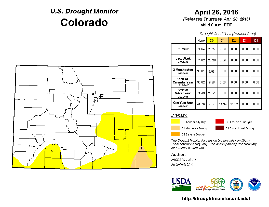
Nearly 75% of the state of Colorado is drought free, while just over 23% is in the abnormally dry (bright yellow) category. However, this past week’s rain/snow is not incorporated into this analysis (it will be in the update on Thursday), so it is likely that the abnormally dry area has shrunk in size. 2% of the state is in the moderate drought category (light brown), which includes portions of Prowers, Bent, Baca, and Las Animas counties. Overall, this is a stark difference from just one year ago, when nearly 36% of the state was under severe drought conditions.
As for El Nino, it has begun to wane. Take a look at the latest SST Anomaly analysis from NOAA/NESDIS below, and notice that each El Nino region has cool anomalies beginning to appear as cooling continues. This indicates the transition to a more neutral phase, albeit still slightly warm. Below the surface, the cool water waits, and the warm top layer is eroding. Most ensembles indicate a transition to La Nina in short order, with several members of those models indicating a moderate La Nina taking shape by Fall.
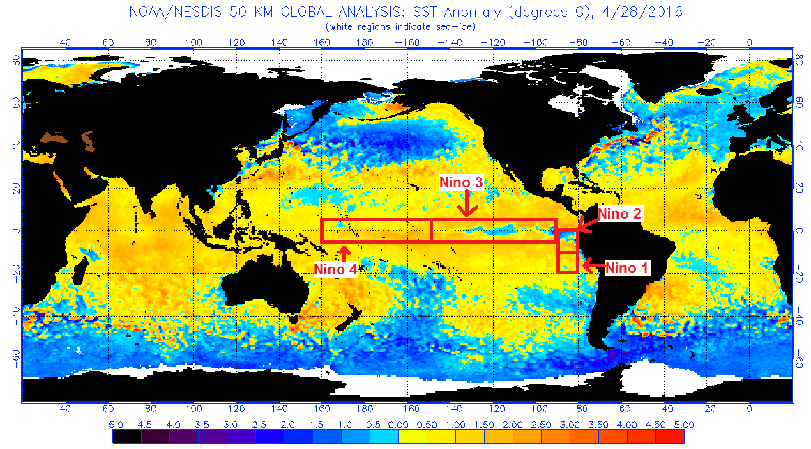
With all of that said, I do not expect the waning El Nino, or appearing La Nina to have any major impacts on Colorado during the 2016 FTO Season. Our antecedent conditions show plenty of moisture available within the soil for summertime thunderstorms, and ensembles hint at slightly above average precipitation during May and June before more “average” conditions take hold for the remainder of the season. Couple those thoughts with the fact that Texas has generally been wet during the last few months, and dry conditions typical of a La Nina will be slow to emerge this season, if at all.
Without any further ado, let’s jump right into the FTO forecast at hand. Taking a look at the water vapor image below, it’s fairly easy to pick out the major players in the first half of this FTO period. First of all, the upper-level ridge that is building over the western US will be in place for the next few days, as the eastward progression is slowed by the amplified atmospheric flow regime. The ridge will finally shift of east of the state by Thursday as the upper-level trough (marked by “Event #1”) moves onshore over California, opening up another wet, cool period for Colorado May 5th – May 8th.
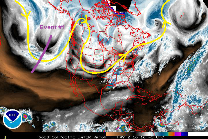
After Event #1, ridging is expected to build across the western US, but confidence is low on how long that will last. At this time, it appears that it will continue until next Thursday-Saturday (12th-14th), before breaking down as an upper-level shortwave trough slides across the region at the end of this FTO period. A shortwave trough that time of year usually presents a chance for stronger thunderstorms and severe weather, especially across the eastern plains. This time period will be important to monitor, and will be re-examined on Thursday’s FTO.
Event #1: Thursday (05-05-2016) through Sunday (05-08-2015)
Upper-Level Low Brings Cool, Wet Period, but No Apparent Flood Threat
As the upper-level trough comes onshore over California, and pushes the ridge east over the central US, south-southwest flow aloft will overspread Colorado. This will increase the mid-level moisture, especially over the higher terrain, which will allow for afternoon convection across the High Country. The lower elevations east of the mountains will likely stay dry on Thursday with afternoon highs near 80 F.
For Friday, south-southwest flow aloft will continue across the state, while a surface low will deepen east of the mountains. The flow around the surface low will transport in better moisture from the south/southeast, and instability will climb. A few stronger storms are possible over the Northeast and Southeast Plains, and perhaps back into the Palmer Ridge and Urban Corridor regions. Garden variety showers and thunderstorms will also be present across the High Country.
On Saturday, scattered showers thunderstorms are likely in the mountains. Out east over the lower elevations, the result is much less certain. Underneath the large scale flow regime that currently exists across the US, predictability is limited in the medium range. There are two scenarios that could unfold:
- The upper-level low is slower to push to the east, leaving the surface low/dryline in favorable position for strong-to-severe storms across eastern Colorado on Saturday
- The upper-level low pushes out quicker than expected, and the surface low/dryline are positioned over Kansas, leaving eastern Colorado generally dry and breezy.
For Sunday, the backside of the upper-level low will bring cool, northwesterly flow to Colorado. Cool air aloft will allow for a few showers and thunderstorms across the state, but rain rates will remain below flash flood thresholds.
Due to uncertainty with the evolution of the upper-level low, and the amount of moisture available, no flood threat is apparent. At this time, it appears that rain rates will remain below flash flood thresholds. Stay tuned for updates in Thursday’s FTO.
