Issue Date: 9/28/2015
Issue Time: 12:27 PM
**THIS IS THE FINAL FLOOD THREAT OUTLOOK OF THE 2015 SEASON. WE WILL POST AN ADDITIONAL SNOWPACK FORECAST WITHIN THE NEXT COUPLE OF HOURS. STAY TUNED.**

After 43 Flood Threat Outlooks, we have finally made it to the final FTO, number 44. In what has been a summer of statewide drought-busting, the final FTO throws another “active” week at Colorado before quieting down as mid-October approaches. Both events in this FTO period occur during the first 6 days, with the final 9 days marked by dry conditions. Without further ado, let’s break down the water vapor image below and then jump right into the individual event discussions.
Event #1 is the result of a steady stream of mid-level moisture from the west and cool, upslope flow at the surface. While the mountains, especially northern and central mountains, will see isolated-to-scattered showers/weak thunderstorms, the focus will be on southeastern Colorado along and near the higher terrain. Cool, upslope flow at the surface in the wake of today’s cool front will increase moisture into the region, and a disturbance embedded in the flow aloft will promote the development of showers and thunderstorms. Tuesday will be the main show, with Wednesday beginning the pattern transition into Event #2.
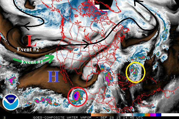
Event #2 brings an elevated flood threat to Colorado, but with caveats. This storm system is fairly low confidence for being 4-6 days out, a result of both its location over the Pacific (lack of observations), and the time period during which it is occurring (transition between seasons). The forecast below reflects a storm track/evolution that is favorable for a wet period (Friday through Sunday) across Colorado. By Sunday night, the upper-level low will be east of the state, with the upper-level ridge building back across the region. The high pressure ridge will likely remain in charge through the remainder of the FTO time frame, bringing about an extended dry period to much of the western US.
Event #1: Tuesday (09-29-2015) and Wednesday (09-30-2015)
No Apparent Flood Threat
A steady stream of mid-level moisture from the west and cool, upslope flow at the surface will bring about Event #1. The main focus for this event will be southern extents of the Front Range/Urban Corridor, western extent of the Southeast Plains, Raton Ridge, and the Southeast Mountains. Upslope flow behind today’s cool front will transport moisture into the region, promoting the development of showers and thunderstorms. Brief periods of moderate rainfall will bring totals near 1 inch within the area outlined on the map, while isolated-to-scattered showers/weak thunderstorms across the High Country will mainly produce light rainfall. Wednesday (and for that matter, Thursday) will be drier as transition begins into this weekend’s system.

Event #2: Friday (10-02-2015) through Sunday (10-04-2015)
Elevated Flood Threat, but Storm System is Still Coming into Focus
The upper-level low will move across the region on Friday afternoon into early Sunday, promoting a 2-to-3 day wet period for Colorado. Eastern Colorado will be the main focus for this event as a cool front surges southward, bringing upslope flow and low-level moisture into the area. Mountain peaks will likely see snow on Friday night and Saturday, as the upper-level low brings much cooler temperatures to Colorado. This forecast will need to be watched closely, as the confidence level is fairly low given the above factors.