Issue Date: 5/05/2016
Issue Time: 1:30 PM
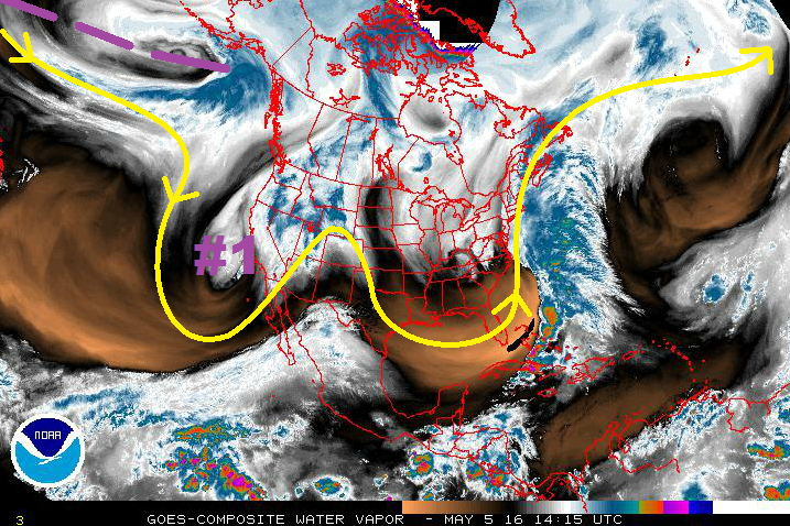
Taking a look at the water vapor image below, the two major players during this FTO period nearly jump off the page. In general, the upper-level pattern is highly amplified, characterized by troughing over the eastern US, ridging over the west-central US, and troughing across the western US (with the upper-level low centered just offshore). This highly amplified pattern will keep things moving slowly, and thus will result in an extended cool, wet period (Event #1) as the upper-level low (denoted by purple “#1”) moves inland and across the region. Event #1 carries with it an elevated flood threat, mainly due to increasing snow melt coinciding with the wet period. Additionally, strong-to-severe storms are possible on Friday/Saturday across northern and northeastern CO, which could be attended by heavier rain rates, depending on how much moisture is available. Those details are best left to the FTB, so stay tuned.
After Event #1, ridging is expected to build across the western US, bringing a drying and warming trend with it back to Colorado. Confidence remains low on how long the ridging will last thanks to this flow regime and the difficulties that come with it. Underneath this ridging, it is important to note that temperatures will warm and increase snow melt. Streamflows will really begin to rise relatively quickly, especially through the High Country, and eventually in the lower elevations.
At this time, it appears the ridging will shift east of Colorado by Sunday/Monday (15th/16th) in advance of the next upper-level trough (marked by the purple dashed line). This upper-level trough (Event #2) is not in a particular hurry to get here, and its details will continue coming into focus over the coming days. No apparent flood threat can be distinguished at this current time.
Friday (05-06-2016) through Wednesday (05-11-2016)
Elevated Flood Threat with Extended Wet Period, Snow Melt, Strong-to-Severe Thunderstorms
For Friday, south-southwest flow aloft will continue across the state, and lift ahead of the upper-level trough will produce scattered showers/thunderstorms across the mountains. For the plains, moisture will be a bit limited overall, except north of a frontal boundary creeping in to northeast Colorado. On the drier/southern side of the frontal boundary thunderstorms will be isolated, and a bit more scattered on the moist/northern side of the boundary. On the dry side of the boundary, including the San Luis Valley, fire conditions will be elevated.
The surface low will continue to deepen on Saturday east of the mountains, with flow around it transporting in better moisture from the south/southeast. A dryline will arc southward from the low, and the other frontal boundary will extend eastward across the Palmer Ridge and onto the plains. Meanwhile, in the mid-levels, a disturbance will rotate overhead. All of these factors together bring the risk for strong-to-severe thunderstorms across eastern Colorado for Saturday. These storms will be bring the threat of heavy rain, in which street/field ponding will be the main flooding concern. Scattered High Country showers/thunderstorms are also expected.
For Sunday-Wednesday, the backside of the upper-level low will bring cool, northwesterly flow to Colorado, wrapping moisture back around into the state. Cool air aloft will allow for a few showers and thunderstorms to develop, mainly across the northern half of the state.
Event #2: Monday (05-16-2016) through Thursday (05-19-2015)
No Apparent Flood Threat
Event #2 is still coming into focus, and we are a few days away from honing in on this particular feature. At this time, it appears the upper-level trough associated with this event will take its time coming onshore and making its way towards Colorado. There are indications that the “slow” regime that we are currently encapsulated by will break down by the middle part of next week, and this upper-level trough will move quicker across the region than that of Event #1. The amount of moisture/instability available, the length of wet period, etc. are still to be determined, and thus no apparent flood threat. Due to this uncertain nature, no precipitation map will be produced. Stay tuned to the next FTO on Monday for another look at this event period.


