FTO 05-19-2016: No Apparent Flood Threats, Severe Weather Returns

Issue Date: 5/19/2016
Issue Time: 12:15 PM

Threat_Timeline_20160519

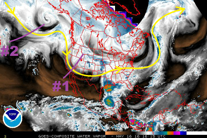
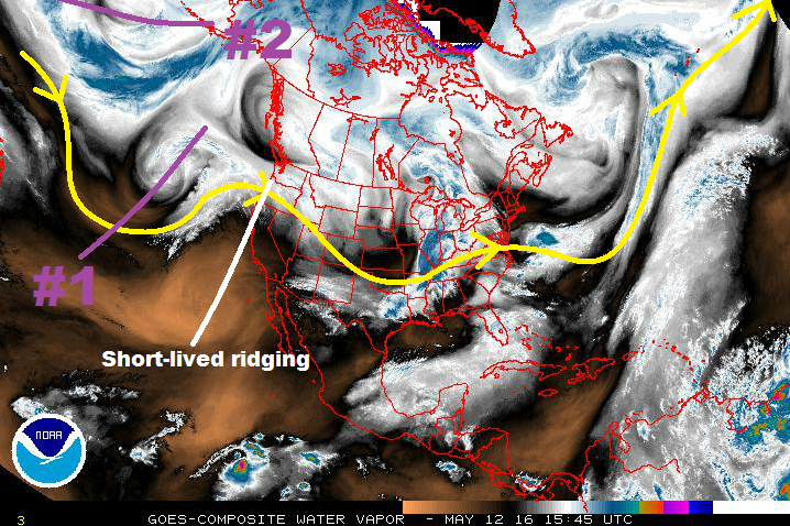
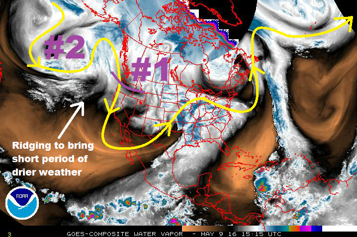
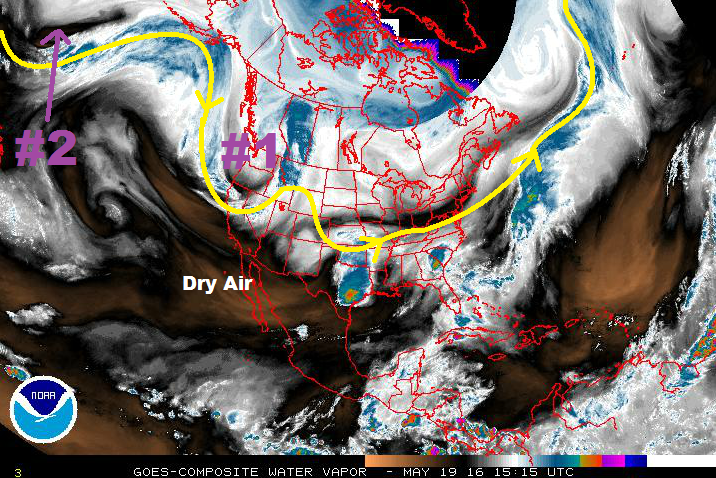
There are two “events” noted in this edition of the FTO, and both can be located on the water vapor imagery below. Event #1 is an upper-level low that will continue to deepen over the West Coast/Great Basin the next couple of days before lifting to the northeast across the Northern Rockies. Behind it, Event #2 is just off screen, but the low-pressure “source region” can be noted in the storm track (yellow line with arrows).

The upper-level low associated with Event #1 will become cut-off and stall for a brief period of time over the West Coast/Great Basin, leaving Colorado under a shortwave ridge for a couple of days. With the south-southwesterly flow in place, dry air (noted in the WV image below) will be ushered into the state, warming temperatures through Saturday afternoon (5/21). There will still be afternoon showers/thunderstorms over the higher terrain/adjacent lower elevations typical of late-May, but a large precipitation event is not expected. With the drier air in place, and mid-level warming occurring, most places across the plains will be capped off. However, by Saturday afternoon, the increased warming of the low-levels by daytime heating (among other factors) will potentially break the cap, resulting in isolated strong-to-severe thunderstorms near the eastern CO border. This will be monitored closely by the daily FTB.

WV_20160519

On Sunday (5/22), the upper-level trough will open up and begin to lift across the Northern Rockies. Disturbances rotating around the base of the trough will assert a larger (relatively speaking) influence on Colorado, but will generally leave the best chance at heavy rain to Wyoming, Nebraska, and Kansas (thanks to the placement of surface features, among other factors) through Wednesday (5/25). The Northeast Plains, and southward along the CO/KS border, will have the best shot at strong-to-severe thunderstorms producing heavy rainfall during Event #1. At this time, it doesn’t appear that a flood threat will materialize. Stay tuned to updates from the daily FTB’s and the FTO on Monday.

Ridging will build overhead in advance of Event #2, keeping Colorado pleasant and mainly dry through Saturday, May 28. The exception to this will be the usual culprit (showers/thunderstorms over/near the higher terrain), but at this time do not appear to hold a heavy rain threat due to a lack of moisture and upper-level support. The upper-level trough associated with Event #2 will begin to impact Colorado on Sunday (5/29) as southwesterly flow aloft begins to transport moisture in, once again. At the surface, a lee-side trough/low pressure circulation will develop, transporting in moisture from the Gulf, and the risk of strong-to-severe storms will return to eastern Colorado. Event #2 looks to bring the best threat for heavy rainfall during this FTO period. Stay tuned to Monday’s FTO for an update on this.

Event #1: Sunday (05-22-2016) through Wednesday (05-25-2016)

No Apparent Flood Threat

Disturbances rotating around the base of the trough will impact Colorado, bringing “bursts” of upper-level support overhead. Generally speaking, however, the best chance at heavy rain will be outside of the state (to the north and east). The Northeast Plains will have the best shot at strong-to-severe thunderstorms producing moderate-to-heavy rainfall during Event #1. The rain rates needed for flash flooding on the plains is much higher than other parts of the state, so no flood threat is warranted at this time.

Legend

Event #2: Sunday (05-29-2016) through Friday (06-03-2016)

No Apparent Flood Threat Yet as Details Still Being Sorted Out

Southwesterly flow aloft will begin to transport moisture in on Sunday (5/29). At the surface, a lee-side trough/low pressure circulation will develop, transporting in moisture from the Gulf, and the risk of strong-to-severe storms will return to eastern Colorado. The track of the upper-level low/trough will need to be watched closely, as it will play a large role in whether or not a flood threat develops, and for how long. There is fairly large uncertainty surrounding this event, so stay tuned for subsequent FTO updates. The precipitation map below depicts the current forecast thinking.

Legend

FTO 05-16-2016: Two Events, One Elevated Flood Threat

Issue Date: 5/16/2016
Issue Time: 1:06 PM

Threat_Timeline_20160516

The two events in this edition of the FTO are fairly easy to spot in the water vapor image below. The first event (denoted by the purple “#1”) is a continuation of the ongoing “event” as discussed in last Thursday’s edition of the FTO. What is currently a slow-moving, closed upper-level low will continue to open up and begin shifting relatively quickly to the east. Event #1 is down to its final 3 days, with each successive day being drier (overall) than the previous.

WV_20160516

After Event #1, ridging takes hold and plans to hang on longer than previously thought, thanks to the upper-level low associated with Event #2 becoming cut-off and stalling over the West Coast. As the upper-level low stalls and ridging builds over Colorado, temperatures will warm and a mostly sunny skies will result through Sunday (5/22). There will still be afternoon showers/thunderstorms over the higher terrain/adjacent valleys typical of late-May, but a large precipitation event is not expected.

On Monday (5/23), disturbances rotating around the base of the trough will assert a larger (relatively speaking) influence on Colorado, but will generally leave the best chance at heavy rain to Wyoming, Nebraska, and Kansas (thanks to the placement of surface features, among other factors) through Thursday (5/26). The Northeast Plains, and southward along the CO/KS border, will have the best shot at strong-to-severe thunderstorms producing heavy rainfall during Event #2.

Further down the road, models really diverge and become inconsistent on the next upper-level low coming down the pipe, so no event discussion will be issued. Briefly speaking, though, if the storm track from Event #2 is any indication, the following upper-level low will likely leave much of Colorado out of the heavy rain threat. Even so, the lower elevations of eastern Colorado will have the best chance at strong-to-severe thunderstorms producing heavy rainfall. Stay tuned to Thursday’s edition of the FTO for an updated look at this scenario.

Event #1: Tuesday (05-17-2016) through Thursday (05-19-2016)

Elevated Flood Threat as Wet Period Winds Down

The ongoing “event” continues, coming to a slow end through Thursday. Tuesday will be the wettest of the three days as the upper-levels continue to provide broad-scale, weak forcing for ascent. All regions will see some rainfall on Tuesday. For Wednesday and Thursday, the focus will be on the mountains, foothills, and adjacent lower elevations for scattered showers/thunderstorms, while the plains hold on to an isolated chance.

Legend

Event #2: Monday (05-23-2016) through Thursday (05-26-2016)

No Apparent Flood Threat

Disturbances rotating around the base of the trough will impact Colorado, bringing “bursts” of upper-level support overhead. Generally speaking, however, the best chance at heavy rain will be outside of the state (to the north and east). The Northeast Plains will have the best shot at strong-to-severe thunderstorms producing heavy rainfall during Event #2. The rain rates needed for flash flooding on the plains is much higher than other parts of the state, so no flood threat is warranted at this time.

Legend

FTO 05-12-2016: Two Events, One Elevated Flood Threat

Issue Date: 5/12/2016
Issue Time: 12:50 PM

Threat_Timeline_20160512

Right on cue, the ridging that has dried out Colorado today, and will tomorrow, is forecast to begin breaking down on Saturday and allow for the reintroduction of showers and thunderstorms. Event #1 (denoted by the purple #1 on the water vapor image below) is riding on the heels of this ridge, and will begin to push onshore the West Coast by Saturday afternoon. This movement will bring moist, southwesterly flow across Colorado, helping to fuel afternoon and evening showers/thunderstorms across the higher terrain and over the adjacent eastern plains. Sunday afternoon/evening will be when Event #1 really kicks into gear, as the upper-level trough encroaches on Colorado. Overall, this trough (while being reinforced/rounded by other disturbances) will influence our weather through Thursday morning before ridging takes over, bringing another short drying trend.

WV_20160512

Event #2 will establish its influence on Colorado next Saturday (5/21) as moist, southwesterly flow increases as it comes onshore the West Coast. As it comes onshore, it is forecast to stall over the West Coast, and complicate the forecast scenario during the remainder of this FTO period. At times, in response to the more-or-less blocked nature of the upper-level trough/low, a couple surface lows will develop along the leeside of the Northern Rockies. The placement of these surface lows and their boundaries (cool front/dryline) will be important to identify. There are a couple of scenarios that could play out:

  1. The cool front/dryline placement keeps the best low-level moisture east of Colorado, limiting the amount of thunderstorm activity, especially across the lower elevations of eastern Colorado
  2. Ample low-level moisture is available, helping to increase instability values, and the boundaries are placed well to provide low-level shear that can support strong-to-severe thunderstorms and heavy rainfall
  3. The most likely scenario is a mixture of the two above scenarios, with days of drying mixed with days of thunderstorms. It will be late May in Colorado, and climatology lends support to this solution.

Meanwhile, the southwesterly flow aloft will rotate ribbons of moisture across the region, bringing isolated-to-scattered showers/thunderstorms to the higher terrain whenever moisture moves overhead. This portion of the forecast period is far from settled, so please check back on Monday for the next FTO edition for an update.

Event #1: Saturday (05-14-2016) through Thursday Morning (05-19-2016)

Elevated Flood Threat during Extended Wet Period

Upper-level ridging will begin to break down on Saturday and allow for the reintroduction of showers and thunderstorms. Concurrently, the upper-level low will push onshore the West Coast by Saturday afternoon. This setup will bring moist, southwesterly flow across Colorado, helping to fuel afternoon and evening showers/thunderstorms across the higher terrain and over the adjacent eastern plains on Saturday. For Sunday afternoon/evening, the upper-level trough will start to encroach on Colorado, increasing the number of showers/thunderstorms. At the same time, easterly flow will develop to the east of the mountains, reinforcing low-level moisture through Tuesday.

Overall, this trough (while being reinforced/rounded by other disturbances) will influence our weather through Thursday morning before ridging takes over, bringing another short drying trend. The wettest days, generally speaking, will be Sunday – Tuesday, thanks to the aforementioned easterly flow and reinforcement of moisture.

Legend

Event #2: Saturday (05-21-2016) through Friday (05-27-2016)

No Apparent Flood Threat

A couple of scenarios could play out, as mentioned above in the main discussion. The most likely of which is a mixture of days with more sunshine and isolated showers/thunderstorms (mainly over the higher terrain) and days with more numerous showers/thunderstorms, some potentially strong-to-severe. Climatologically speaking, that’s late May in a nutshell. The stalling/blocked upper-level low/trough complicates the forecast, making this period as clear as mud. Due to this, no precipitation map will be drawn. Stay tuned to the next FTO on Monday for an update on this period.

FTO 05-09-2016: Three Events During this Period, One Elevated Flood Threat

Issue Date: 5/9/2016
Issue Time: 12:40 PM

Threat_Timeline_20160509

An active period is ahead as the atmosphere breaks down out of its pseudo-blocking pattern and upper-level features become a bit more transient across the region. Taking a look at the water vapor image below, we can break down the first two events on the horizon. Event #1 is on the doorstep as an upper-level disturbance/trough swings across the northern states and drops moisture and a cool front into Colorado. Ridging will then build across the region on Thursday and Friday, bringing warmer temperatures and mostly dry conditions. The exception will be over/near the higher terrain, where isolated thunderstorms will remain possible owing to orographic effects and residual moisture.

WV_20160509

Event #2 will begin on Saturday as the ridge breaks down ahead of the next upper-level low. Cloud cover will increase on Saturday, with isolated-to-scattered showers and thunderstorms possible across the state. The better rain chances arrive on Sunday/Monday in association with the cool front and easterly, upslope flow behind the front. Ridging will again build in after Event #2, resulting in much the same conditions as the previously mentioned ridging.

Models really diverge after this weekend, but it appears that a third event will take place, beginning on Friday, May 20th. At this time, it looks like another upper-level low will come onshore California and force southwesterly flow over Colorado late next week. In the more transient nature of the upper-level flow, this event looks to be fairly short duration (2-3 days) as the low moves off to the east/northeast in short order.

Event #1: Tuesday (05-10-2016) and Wednesday (05-11-2016)

Elevated Flood Threat

An upper-level disturbance/trough will swing across the northern states, dropping moisture and a cool front into Colorado. Scattered showers and thunderstorms are expected across all regions, with the bulk of the best precipitation occurring along and south of I-70. A couple of storms across the lower elevations may become severe, but instability will be a limiting factor. Shallow, upslope flow will materialize briefly on Wednesday afternoon, potentially focusing heavier rain along the foothills, Urban Corridor, and western extents of the Southeast Plains.

Legend

Event #2: Saturday (05-14-2016) through Tuesday Morning (05-17-2016)

No Apparent Flood Threat

Cloud cover will increase on Saturday as large-scale lift overspreads the region ahead of the next upper-level low. Isolated-to-scattered showers and thunderstorms will be possible across the state. The better rain chances arrive on Sunday/Monday in association with the cool front/mid-level disturbance.

Legend

Event #3: Friday (05-20-2016) through Sunday (05-22-2016)

No Apparent Flood Threat

Model solutions diverge after this weekend/early next week, but looking at water vapor imagery, there is a third disturbance waiting in the wings over the Bering Sea. The best estimate of its effects arriving in the region are late next week, approximately Friday, May 20th. That is when moist, southwesterly flow will begin to overspread Colorado, once again. At this time, this event looks to be relatively short duration (2-3 days). We will continue to monitor this disturbance over the coming days. Stay tuned.