Issue Date: 5/9/2016
Issue Time: 12:40 PM

An active period is ahead as the atmosphere breaks down out of its pseudo-blocking pattern and upper-level features become a bit more transient across the region. Taking a look at the water vapor image below, we can break down the first two events on the horizon. Event #1 is on the doorstep as an upper-level disturbance/trough swings across the northern states and drops moisture and a cool front into Colorado. Ridging will then build across the region on Thursday and Friday, bringing warmer temperatures and mostly dry conditions. The exception will be over/near the higher terrain, where isolated thunderstorms will remain possible owing to orographic effects and residual moisture.
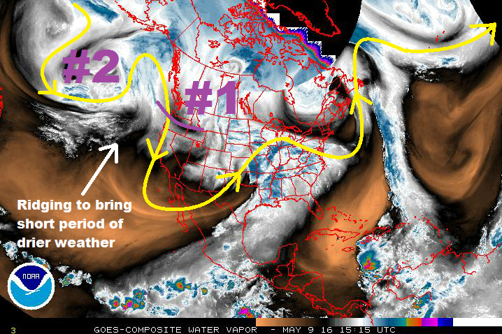
Event #2 will begin on Saturday as the ridge breaks down ahead of the next upper-level low. Cloud cover will increase on Saturday, with isolated-to-scattered showers and thunderstorms possible across the state. The better rain chances arrive on Sunday/Monday in association with the cool front and easterly, upslope flow behind the front. Ridging will again build in after Event #2, resulting in much the same conditions as the previously mentioned ridging.
Models really diverge after this weekend, but it appears that a third event will take place, beginning on Friday, May 20th. At this time, it looks like another upper-level low will come onshore California and force southwesterly flow over Colorado late next week. In the more transient nature of the upper-level flow, this event looks to be fairly short duration (2-3 days) as the low moves off to the east/northeast in short order.
Event #1: Tuesday (05-10-2016) and Wednesday (05-11-2016)
Elevated Flood Threat
An upper-level disturbance/trough will swing across the northern states, dropping moisture and a cool front into Colorado. Scattered showers and thunderstorms are expected across all regions, with the bulk of the best precipitation occurring along and south of I-70. A couple of storms across the lower elevations may become severe, but instability will be a limiting factor. Shallow, upslope flow will materialize briefly on Wednesday afternoon, potentially focusing heavier rain along the foothills, Urban Corridor, and western extents of the Southeast Plains.

Event #2: Saturday (05-14-2016) through Tuesday Morning (05-17-2016)
No Apparent Flood Threat
Cloud cover will increase on Saturday as large-scale lift overspreads the region ahead of the next upper-level low. Isolated-to-scattered showers and thunderstorms will be possible across the state. The better rain chances arrive on Sunday/Monday in association with the cool front/mid-level disturbance.
Event #3: Friday (05-20-2016) through Sunday (05-22-2016)
No Apparent Flood Threat
Model solutions diverge after this weekend/early next week, but looking at water vapor imagery, there is a third disturbance waiting in the wings over the Bering Sea. The best estimate of its effects arriving in the region are late next week, approximately Friday, May 20th. That is when moist, southwesterly flow will begin to overspread Colorado, once again. At this time, this event looks to be relatively short duration (2-3 days). We will continue to monitor this disturbance over the coming days. Stay tuned.