Issue Date: 5/16/2016
Issue Time: 1:06 PM

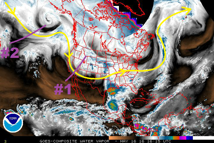
The two events in this edition of the FTO are fairly easy to spot in the water vapor image below. The first event (denoted by the purple “#1”) is a continuation of the ongoing “event” as discussed in last Thursday’s edition of the FTO. What is currently a slow-moving, closed upper-level low will continue to open up and begin shifting relatively quickly to the east. Event #1 is down to its final 3 days, with each successive day being drier (overall) than the previous.
After Event #1, ridging takes hold and plans to hang on longer than previously thought, thanks to the upper-level low associated with Event #2 becoming cut-off and stalling over the West Coast. As the upper-level low stalls and ridging builds over Colorado, temperatures will warm and a mostly sunny skies will result through Sunday (5/22). There will still be afternoon showers/thunderstorms over the higher terrain/adjacent valleys typical of late-May, but a large precipitation event is not expected.
On Monday (5/23), disturbances rotating around the base of the trough will assert a larger (relatively speaking) influence on Colorado, but will generally leave the best chance at heavy rain to Wyoming, Nebraska, and Kansas (thanks to the placement of surface features, among other factors) through Thursday (5/26). The Northeast Plains, and southward along the CO/KS border, will have the best shot at strong-to-severe thunderstorms producing heavy rainfall during Event #2.
Further down the road, models really diverge and become inconsistent on the next upper-level low coming down the pipe, so no event discussion will be issued. Briefly speaking, though, if the storm track from Event #2 is any indication, the following upper-level low will likely leave much of Colorado out of the heavy rain threat. Even so, the lower elevations of eastern Colorado will have the best chance at strong-to-severe thunderstorms producing heavy rainfall. Stay tuned to Thursday’s edition of the FTO for an updated look at this scenario.
Event #1: Tuesday (05-17-2016) through Thursday (05-19-2016)
Elevated Flood Threat as Wet Period Winds Down
The ongoing “event” continues, coming to a slow end through Thursday. Tuesday will be the wettest of the three days as the upper-levels continue to provide broad-scale, weak forcing for ascent. All regions will see some rainfall on Tuesday. For Wednesday and Thursday, the focus will be on the mountains, foothills, and adjacent lower elevations for scattered showers/thunderstorms, while the plains hold on to an isolated chance.

Event #2: Monday (05-23-2016) through Thursday (05-26-2016)
No Apparent Flood Threat
Disturbances rotating around the base of the trough will impact Colorado, bringing “bursts” of upper-level support overhead. Generally speaking, however, the best chance at heavy rain will be outside of the state (to the north and east). The Northeast Plains will have the best shot at strong-to-severe thunderstorms producing heavy rainfall during Event #2. The rain rates needed for flash flooding on the plains is much higher than other parts of the state, so no flood threat is warranted at this time.