Issue Date: 5/12/2016
Issue Time: 12:50 PM

Right on cue, the ridging that has dried out Colorado today, and will tomorrow, is forecast to begin breaking down on Saturday and allow for the reintroduction of showers and thunderstorms. Event #1 (denoted by the purple #1 on the water vapor image below) is riding on the heels of this ridge, and will begin to push onshore the West Coast by Saturday afternoon. This movement will bring moist, southwesterly flow across Colorado, helping to fuel afternoon and evening showers/thunderstorms across the higher terrain and over the adjacent eastern plains. Sunday afternoon/evening will be when Event #1 really kicks into gear, as the upper-level trough encroaches on Colorado. Overall, this trough (while being reinforced/rounded by other disturbances) will influence our weather through Thursday morning before ridging takes over, bringing another short drying trend.
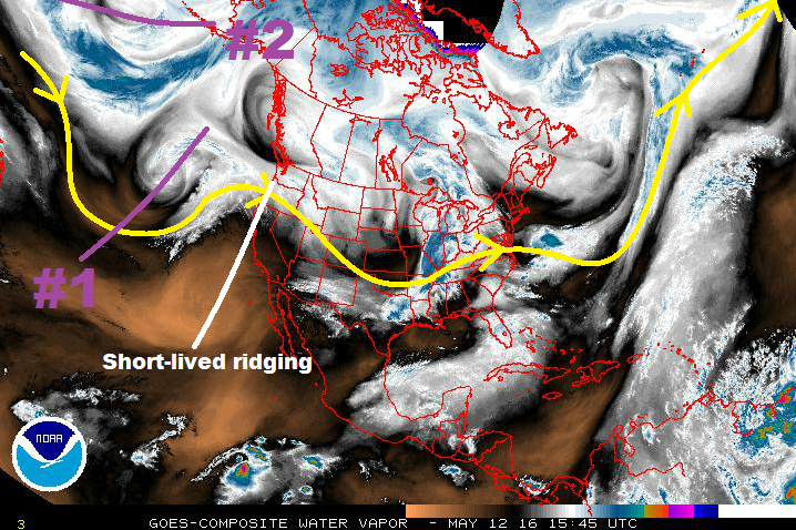
Event #2 will establish its influence on Colorado next Saturday (5/21) as moist, southwesterly flow increases as it comes onshore the West Coast. As it comes onshore, it is forecast to stall over the West Coast, and complicate the forecast scenario during the remainder of this FTO period. At times, in response to the more-or-less blocked nature of the upper-level trough/low, a couple surface lows will develop along the leeside of the Northern Rockies. The placement of these surface lows and their boundaries (cool front/dryline) will be important to identify. There are a couple of scenarios that could play out:
- The cool front/dryline placement keeps the best low-level moisture east of Colorado, limiting the amount of thunderstorm activity, especially across the lower elevations of eastern Colorado
- Ample low-level moisture is available, helping to increase instability values, and the boundaries are placed well to provide low-level shear that can support strong-to-severe thunderstorms and heavy rainfall
- The most likely scenario is a mixture of the two above scenarios, with days of drying mixed with days of thunderstorms. It will be late May in Colorado, and climatology lends support to this solution.
Meanwhile, the southwesterly flow aloft will rotate ribbons of moisture across the region, bringing isolated-to-scattered showers/thunderstorms to the higher terrain whenever moisture moves overhead. This portion of the forecast period is far from settled, so please check back on Monday for the next FTO edition for an update.
Event #1: Saturday (05-14-2016) through Thursday Morning (05-19-2016)
Elevated Flood Threat during Extended Wet Period
Upper-level ridging will begin to break down on Saturday and allow for the reintroduction of showers and thunderstorms. Concurrently, the upper-level low will push onshore the West Coast by Saturday afternoon. This setup will bring moist, southwesterly flow across Colorado, helping to fuel afternoon and evening showers/thunderstorms across the higher terrain and over the adjacent eastern plains on Saturday. For Sunday afternoon/evening, the upper-level trough will start to encroach on Colorado, increasing the number of showers/thunderstorms. At the same time, easterly flow will develop to the east of the mountains, reinforcing low-level moisture through Tuesday.
Overall, this trough (while being reinforced/rounded by other disturbances) will influence our weather through Thursday morning before ridging takes over, bringing another short drying trend. The wettest days, generally speaking, will be Sunday – Tuesday, thanks to the aforementioned easterly flow and reinforcement of moisture.

Event #2: Saturday (05-21-2016) through Friday (05-27-2016)
No Apparent Flood Threat
A couple of scenarios could play out, as mentioned above in the main discussion. The most likely of which is a mixture of days with more sunshine and isolated showers/thunderstorms (mainly over the higher terrain) and days with more numerous showers/thunderstorms, some potentially strong-to-severe. Climatologically speaking, that’s late May in a nutshell. The stalling/blocked upper-level low/trough complicates the forecast, making this period as clear as mud. Due to this, no precipitation map will be drawn. Stay tuned to the next FTO on Monday for an update on this period.