Issue Date: 5/19/2016
Issue Time: 12:15 PM
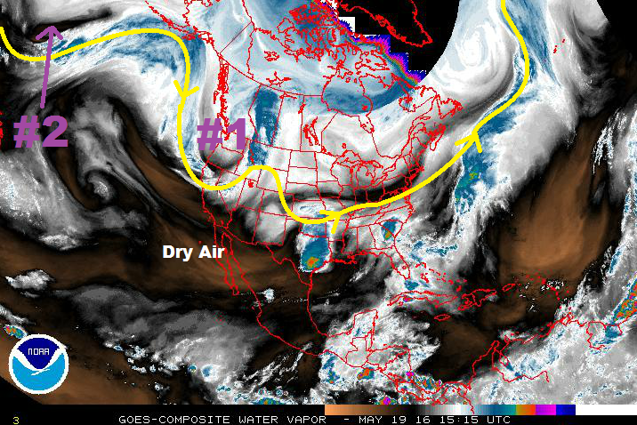
There are two “events” noted in this edition of the FTO, and both can be located on the water vapor imagery below. Event #1 is an upper-level low that will continue to deepen over the West Coast/Great Basin the next couple of days before lifting to the northeast across the Northern Rockies. Behind it, Event #2 is just off screen, but the low-pressure “source region” can be noted in the storm track (yellow line with arrows).
The upper-level low associated with Event #1 will become cut-off and stall for a brief period of time over the West Coast/Great Basin, leaving Colorado under a shortwave ridge for a couple of days. With the south-southwesterly flow in place, dry air (noted in the WV image below) will be ushered into the state, warming temperatures through Saturday afternoon (5/21). There will still be afternoon showers/thunderstorms over the higher terrain/adjacent lower elevations typical of late-May, but a large precipitation event is not expected. With the drier air in place, and mid-level warming occurring, most places across the plains will be capped off. However, by Saturday afternoon, the increased warming of the low-levels by daytime heating (among other factors) will potentially break the cap, resulting in isolated strong-to-severe thunderstorms near the eastern CO border. This will be monitored closely by the daily FTB.
On Sunday (5/22), the upper-level trough will open up and begin to lift across the Northern Rockies. Disturbances rotating around the base of the trough will assert a larger (relatively speaking) influence on Colorado, but will generally leave the best chance at heavy rain to Wyoming, Nebraska, and Kansas (thanks to the placement of surface features, among other factors) through Wednesday (5/25). The Northeast Plains, and southward along the CO/KS border, will have the best shot at strong-to-severe thunderstorms producing heavy rainfall during Event #1. At this time, it doesn’t appear that a flood threat will materialize. Stay tuned to updates from the daily FTB’s and the FTO on Monday.
Ridging will build overhead in advance of Event #2, keeping Colorado pleasant and mainly dry through Saturday, May 28. The exception to this will be the usual culprit (showers/thunderstorms over/near the higher terrain), but at this time do not appear to hold a heavy rain threat due to a lack of moisture and upper-level support. The upper-level trough associated with Event #2 will begin to impact Colorado on Sunday (5/29) as southwesterly flow aloft begins to transport moisture in, once again. At the surface, a lee-side trough/low pressure circulation will develop, transporting in moisture from the Gulf, and the risk of strong-to-severe storms will return to eastern Colorado. Event #2 looks to bring the best threat for heavy rainfall during this FTO period. Stay tuned to Monday’s FTO for an update on this.
Event #1: Sunday (05-22-2016) through Wednesday (05-25-2016)
No Apparent Flood Threat
Disturbances rotating around the base of the trough will impact Colorado, bringing “bursts” of upper-level support overhead. Generally speaking, however, the best chance at heavy rain will be outside of the state (to the north and east). The Northeast Plains will have the best shot at strong-to-severe thunderstorms producing moderate-to-heavy rainfall during Event #1. The rain rates needed for flash flooding on the plains is much higher than other parts of the state, so no flood threat is warranted at this time.
Event #2: Sunday (05-29-2016) through Friday (06-03-2016)
No Apparent Flood Threat Yet as Details Still Being Sorted Out
Southwesterly flow aloft will begin to transport moisture in on Sunday (5/29). At the surface, a lee-side trough/low pressure circulation will develop, transporting in moisture from the Gulf, and the risk of strong-to-severe storms will return to eastern Colorado. The track of the upper-level low/trough will need to be watched closely, as it will play a large role in whether or not a flood threat develops, and for how long. There is fairly large uncertainty surrounding this event, so stay tuned for subsequent FTO updates. The precipitation map below depicts the current forecast thinking.


