FTO 06-16-2016: Two Events on the Horizon, No Apparent Flood Threats

Issue Date: 6/16/2016
Issue Time: 11:55 AM

Threat_Timeline_20160616

The ridge currently situated over the Central US will continue its status as the dominant weather feature for Colorado through Sunday (June 19). This will keep the heat turned on for the next few days, flirting with 100 degrees in a few locations. However, there is one minor note for Friday (June 17): A weak boundary will slide into northeastern Colorado, kicking off a couple isolated thunderstorms Friday afternoon through Saturday morning across the northern Front Range, northern Urban Corridor, and Northeast Plains regions. Moisture will be on the low side, so any heavy rain will be brief and likely confined to the far Northeast Plains. There’s not enough of a threat to warrant an event classification.

WV_20160616

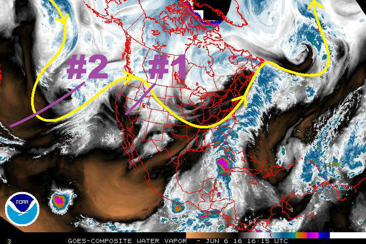
Instead, Event #1 will start on Monday afternoon as the upper-level trough/low (purple “#1” in water vapor image) slides across the Northern Rockies and flattens the upper-level ridge. A cool front associated with this system will move across eastern Colorado, cooling high temperatures and increasing low-level moisture. Thunderstorm chances will be best along and east of I-25, with only isolated chances over the higher terrain along and east of the Continental Divide. Locations further west will likely miss out on the rain chances entirely.

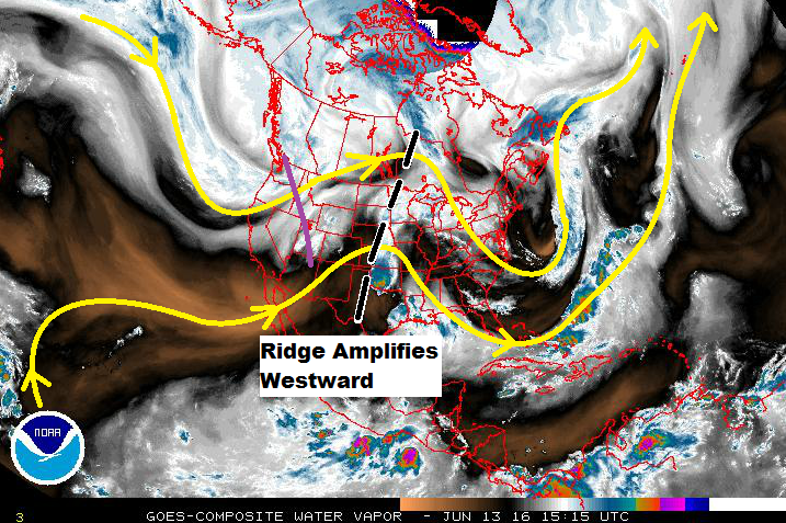
At any rate, the moisture push and cooler temperatures appear to be short-lived, with the ridge amplifying and another drying/warming trend beginning by Wednesday (June 22). The upper ridging will maintain its grip on the western US through the remainder of the week, but by Saturday (June 25) another upper-level low will begin to flatten the ridge and bring storm chances back to Colorado. We will label this as Event #2, but it carries an “uncertainty” disclaimer. Model solutions diverge on key features, so we will continue to monitor this time frame. Stay tuned to the next FTO on Monday for an updated look.

Event #1: Monday (06-20-2016) through Wednesday morning (06-22-2016)

No Apparent Flood Threat as Upper Ridge Flattens and Cool Front Moves In

The dominant upper-level ridge will flatten as an upper-level trough slides across the Northern Rockies. Moisture will increase across eastern Colorado behind the cool front, but just how much moisture remains a question. At this time, the setup favors thunderstorms producing gusty winds, hail, and lightning, with rainfall being a secondary impact. Depending on the depth of the moisture return, a flood threat could appear during this time frame. Stay tuned to the daily FTB.

Legend

Event #2: Saturday (06-25-2016) through Monday (06-27-2016)

No Apparent Flood Threat due to Uncertainty Surrounding Key Features

Similar to Event #1, Event #2 will be the result of the upper-level ridge being flattened as an upper-level low slides across the northern US. A cool front will likely slide across eastern Colorado, just as Event #1. At this time, the upper-level pattern looks to be favorable for more thunderstorm coverage than Event #1, and this will be one of the important features to monitor. Due to the uncertainty surrounding this event period, no flood threat is apparent. Stay tuned to subsequent FTO’s for updates.

Legend

FTO 06-13-2016: No Apparent Flood Threats in the next 15 Days

Issue Date: 6/13/2016
Issue Time: 11:30 AM

Threat_Timeline_20160613

After what has been a fairly active first half of June, Mother Nature is going to dial it down and allow for summertime heat and sunshine to take over. Today’s active weather (discussed in this morning’s FTB) will be the last big hurrah for flooding threats for the foreseeable future, as this 15 day period features only two events, neither of which are accompanied by a flood threat. The first event is really the final day of the ongoing event, as the upper-level wave (purple line) will move out the state by Tuesday night. Moisture will be fairly low as drier air is pulled up from the south-southwest, limiting the threat of any heavy rainfall.

WV_20160613

After Event #1, the ridge currently over the Central US will amplify westward, becoming the dominant weather feature for Colorado through Tuesday (June 21st). High temperatures will be hot during this period, and more than a few locations will reach into the upper 90s/near 100, especially across the Arkansas River Valley and far southeastern plains. Event #2 is the result of the dominant upper-ridge being flattened by an upper-level low passing across the northern Rockies. This would create a more “neutral” atmospheric state, allowing orographic influences to produce garden-variety showers/thunderstorms. After Event #2, the ridge amplifies again, leaving Colorado to bask in the summer sun.

Event #1: Tuesday (06-14-2016)

No Apparent Flood Threat as Moisture Exits

As the final day of the ongoing event, Tuesday will see the upper-level wave move east of the state by Tuesday night. Drier air will move in from the west-southwest, eliminating the threat of heavy rainfall. In fact, no location is expected to receive greater than 0.5 inches of total rainfall. Thus, no QPF shading on the precipitation map below.

Legend

Wednesday (06-22-2016) through Saturday (06-25-2016)

No Apparent Flood Threat as Upper Ridge Flattens

The dominant upper-level ridge will flatten as an upper-level trough slides across the Northern Rockies. This will allow for the diurnal cycle of showers/thunderstorms to kick back up thanks to orographic influences. At this time, it appears that moisture will be meager, leaving storms to produce more gusty winds and lightning than rain. Stay tuned for the next FTO on Thursday as we get another look at this period.

Legend

FTO 06-09-2016: Elevated Flood Threat Begins This Weekend

Issue Date: 6/9/2016
Issue Time: 12:32 PM

Threat_Timeline_20160609

Looking at the water vapor imagery below, the first event (bringing an elevated flood threat) is fairly easy to pick out. Currently, Colorado resides under the expansive high pressure ridge that has built in from the west and is shifting towards the central US. Behind it, however, is the next trough poised to bring an unsettled period to the region.

By Saturday afternoon, the upper-level trough associated with Event #1 will be in a favorable position to bring in slightly cooler air as it breaks down the ridge. Subtropical moisture will be transported in from the south/southwest, bringing an increase in afternoon/evening thunderstorms. As the upper-low continues its trek east-northeastward, it will split into two main disturbances. Disturbance #1A will move across the Northern Rockies and into Canada, while disturbance #1B will move across the Great Basin and then across Colorado on Monday/Tuesday.

The best chance at heavy rain and potential flash flooding issues will be on Monday and Tuesday, associated with #1B and the passage of a cool front. Behind this wave, the upper-level ridge will build across the western US in earnest, allowing sunshine to return and temperatures to climb. Diurnally driven, isolated, high country showers/thunderstorms will continue during this drier period, working off of residual moisture and orographic forcing.

WV_20160609

Event #2 lurks further out in the extended range, bringing the next unsettled period to Colorado for Monday, June 20th through Wednesday, June 23rd. This period will be the result of an upper-level low moving onshore the West Coast, initially bringing cooler, more moist, southwest flow aloft. Eventually, the upper trough will slide to the northeast, providing broad-scale support for scattered showers and thunderstorms. An upper-level ridge will build in quickly behind this trough, ushering in another warming/drying trend to close out this FTO period.

Event #1: Saturday Afternoon (06-11-2016) through Tuesday (06-14-2016)

Elevated Flood Threat as Upper-Level Trough Breaks Down the Ridge

By Saturday afternoon, the upper-level trough associated with Event #1 will be in a favorable position to bring in slightly cooler air as it breaks down the ridge. Subtropical moisture will be transported in from the south/southwest, bringing an increase in afternoon/evening thunderstorms. As the upper-low continues its trek east-northeastward, it will split into two main disturbances. Disturbance #1A will move across the Northern Rockies and into Canada, while disturbance #1B will move across the Great Basin and then across Colorado on Monday/Tuesday.

The best chance at heavy rain and potential flash flooding issues will be on Monday and Tuesday, associated with #1B and the passage of a cool front. It will be those days that the best moisture/large-scale support overlap will occur.

Legend

Event #2: Monday (06-20-2016) through Thursday (06-23-2016)

No Apparent Flood Threat as the Event is Still Coming into Focus

Event #2 carries some uncertainty with it, not unlike most events noted in the 10-15 day range. At this time, it appears to bring the next unsettled period to Colorado for Monday, June 20th through Wednesday, June 23rd. The upper-level low will spend a few days prior digging southward just offshore before moving over west coast states on Sunday/Monday. Initially, this will result in cooler, moister air being transported into Colorado within the southwest flow aloft. Eventually, the upper trough will slide to the northeast, providing broad-scale support for scattered showers and thunderstorms.

Legend

FTO 06-06-2016: Two Events, One Elevated Flood Threat

Issue Date: 6/6/2016
Issue Time: 1:08 PM

Threat_Timeline_20160606

As discussed in the previous two Flood Threat Outlooks, a ridge has expanded and set up shop over the western US. This is a typical pattern during the summer months, and will prop up Colorado’s temperatures for some time to come. Also typical of the summer time are upper-level lows/troughs that will try to flatten the ridge with varying degrees of success. Event #1 is a weak upper-level wave that undercut the larger scale ridging. This wave is bringing about an active period (that actually began today) through Wednesday as it moves slowly across the region. Behind this wave, the upper ridge axis will move across Colorado, bringing a warming and drying trend through the end of this work week and into the weekend. The far eastern plains will see a few locations top out around 95 degrees.

WV_20160606

By late Saturday/early Sunday, the upper-level trough associated with Event #2 will be in a favorable position to bring in slightly cooler air as it breaks down the ridge. Subtropical moisture will be transported in from the south/southwest, bringing an increase in afternoon/evening thunderstorms. As the upper-low continues its trek east-northeastward, it will split in two, allowing a wave disturbance to pass over Colorado Monday and Tuesday. The best chance at heavy rain and potential flash flooding issues will be on those days. Behind this wave, the upper-level ridge will build across the western US in earnest, allowing sunshine to return and temperatures to climb. Before this period is over, there will be a few locations flirt with 95-100 degrees.

Event #1: Tuesday (06-07-2016) and Wednesday (06-08-2016)

No Apparent Flood Threat as Weak Upper-Level Low Exits Region

The weak upper-level wave that undercut the larger scale ridging will continue the active period through Wednesday as it moves slowly across the region. Each day will feature fewer showers and thunderstorms than the previous as the atmosphere dries out slightly and the upper-levels become less favorable to upward motion. A couple strong-to-severe storms will be possible across eastern Colorado during the afternoon/evening on Tuesday, with the main threats being gusty winds, hail, and lightning.

Legend

Event #2: Sunday (06-12-2016) through Tuesday (06-14-2016)

Elevated Flood Threat as Upper-Level Trough Breaks Down the Ridge

By late Saturday/early Sunday, south-southwesterly flow will transport subtropical moisture into the state, along with cooler air aloft, leading to an increase in afternoon/evening thunderstorms. As the upper-low continues its trek east-northeastward, it will split in two, allowing a wave disturbance to pass over Colorado Monday and Tuesday. Meanwhile, low-level upslope flow will transport moisture into eastern Colorado from the Great Plains. The best chance at heavy rain and potential flash flooding issues will be on those days as the best moisture/large-scale support overlap.

Legend