Issue Date: 6/9/2016
Issue Time: 12:32 PM

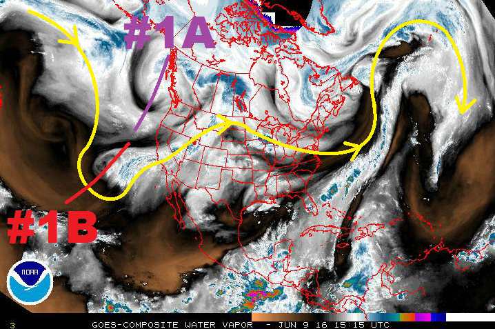
Looking at the water vapor imagery below, the first event (bringing an elevated flood threat) is fairly easy to pick out. Currently, Colorado resides under the expansive high pressure ridge that has built in from the west and is shifting towards the central US. Behind it, however, is the next trough poised to bring an unsettled period to the region.
By Saturday afternoon, the upper-level trough associated with Event #1 will be in a favorable position to bring in slightly cooler air as it breaks down the ridge. Subtropical moisture will be transported in from the south/southwest, bringing an increase in afternoon/evening thunderstorms. As the upper-low continues its trek east-northeastward, it will split into two main disturbances. Disturbance #1A will move across the Northern Rockies and into Canada, while disturbance #1B will move across the Great Basin and then across Colorado on Monday/Tuesday.
The best chance at heavy rain and potential flash flooding issues will be on Monday and Tuesday, associated with #1B and the passage of a cool front. Behind this wave, the upper-level ridge will build across the western US in earnest, allowing sunshine to return and temperatures to climb. Diurnally driven, isolated, high country showers/thunderstorms will continue during this drier period, working off of residual moisture and orographic forcing.
Event #2 lurks further out in the extended range, bringing the next unsettled period to Colorado for Monday, June 20th through Wednesday, June 23rd. This period will be the result of an upper-level low moving onshore the West Coast, initially bringing cooler, more moist, southwest flow aloft. Eventually, the upper trough will slide to the northeast, providing broad-scale support for scattered showers and thunderstorms. An upper-level ridge will build in quickly behind this trough, ushering in another warming/drying trend to close out this FTO period.
Event #1: Saturday Afternoon (06-11-2016) through Tuesday (06-14-2016)
Elevated Flood Threat as Upper-Level Trough Breaks Down the Ridge
By Saturday afternoon, the upper-level trough associated with Event #1 will be in a favorable position to bring in slightly cooler air as it breaks down the ridge. Subtropical moisture will be transported in from the south/southwest, bringing an increase in afternoon/evening thunderstorms. As the upper-low continues its trek east-northeastward, it will split into two main disturbances. Disturbance #1A will move across the Northern Rockies and into Canada, while disturbance #1B will move across the Great Basin and then across Colorado on Monday/Tuesday.
The best chance at heavy rain and potential flash flooding issues will be on Monday and Tuesday, associated with #1B and the passage of a cool front. It will be those days that the best moisture/large-scale support overlap will occur.

Event #2: Monday (06-20-2016) through Thursday (06-23-2016)
No Apparent Flood Threat as the Event is Still Coming into Focus
Event #2 carries some uncertainty with it, not unlike most events noted in the 10-15 day range. At this time, it appears to bring the next unsettled period to Colorado for Monday, June 20th through Wednesday, June 23rd. The upper-level low will spend a few days prior digging southward just offshore before moving over west coast states on Sunday/Monday. Initially, this will result in cooler, moister air being transported into Colorado within the southwest flow aloft. Eventually, the upper trough will slide to the northeast, providing broad-scale support for scattered showers and thunderstorms.