Issue Date: 6/16/2016
Issue Time: 11:55 AM
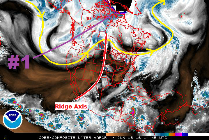
The ridge currently situated over the Central US will continue its status as the dominant weather feature for Colorado through Sunday (June 19). This will keep the heat turned on for the next few days, flirting with 100 degrees in a few locations. However, there is one minor note for Friday (June 17): A weak boundary will slide into northeastern Colorado, kicking off a couple isolated thunderstorms Friday afternoon through Saturday morning across the northern Front Range, northern Urban Corridor, and Northeast Plains regions. Moisture will be on the low side, so any heavy rain will be brief and likely confined to the far Northeast Plains. There’s not enough of a threat to warrant an event classification.
Instead, Event #1 will start on Monday afternoon as the upper-level trough/low (purple “#1” in water vapor image) slides across the Northern Rockies and flattens the upper-level ridge. A cool front associated with this system will move across eastern Colorado, cooling high temperatures and increasing low-level moisture. Thunderstorm chances will be best along and east of I-25, with only isolated chances over the higher terrain along and east of the Continental Divide. Locations further west will likely miss out on the rain chances entirely.
At any rate, the moisture push and cooler temperatures appear to be short-lived, with the ridge amplifying and another drying/warming trend beginning by Wednesday (June 22). The upper ridging will maintain its grip on the western US through the remainder of the week, but by Saturday (June 25) another upper-level low will begin to flatten the ridge and bring storm chances back to Colorado. We will label this as Event #2, but it carries an “uncertainty” disclaimer. Model solutions diverge on key features, so we will continue to monitor this time frame. Stay tuned to the next FTO on Monday for an updated look.
Event #1: Monday (06-20-2016) through Wednesday morning (06-22-2016)
No Apparent Flood Threat as Upper Ridge Flattens and Cool Front Moves In
The dominant upper-level ridge will flatten as an upper-level trough slides across the Northern Rockies. Moisture will increase across eastern Colorado behind the cool front, but just how much moisture remains a question. At this time, the setup favors thunderstorms producing gusty winds, hail, and lightning, with rainfall being a secondary impact. Depending on the depth of the moisture return, a flood threat could appear during this time frame. Stay tuned to the daily FTB.
Event #2: Saturday (06-25-2016) through Monday (06-27-2016)
No Apparent Flood Threat due to Uncertainty Surrounding Key Features
Similar to Event #1, Event #2 will be the result of the upper-level ridge being flattened as an upper-level low slides across the northern US. A cool front will likely slide across eastern Colorado, just as Event #1. At this time, the upper-level pattern looks to be favorable for more thunderstorm coverage than Event #1, and this will be one of the important features to monitor. Due to the uncertainty surrounding this event period, no flood threat is apparent. Stay tuned to subsequent FTO’s for updates.


