Issue Date: 6/6/2016
Issue Time: 1:08 PM

As discussed in the previous two Flood Threat Outlooks, a ridge has expanded and set up shop over the western US. This is a typical pattern during the summer months, and will prop up Colorado’s temperatures for some time to come. Also typical of the summer time are upper-level lows/troughs that will try to flatten the ridge with varying degrees of success. Event #1 is a weak upper-level wave that undercut the larger scale ridging. This wave is bringing about an active period (that actually began today) through Wednesday as it moves slowly across the region. Behind this wave, the upper ridge axis will move across Colorado, bringing a warming and drying trend through the end of this work week and into the weekend. The far eastern plains will see a few locations top out around 95 degrees.
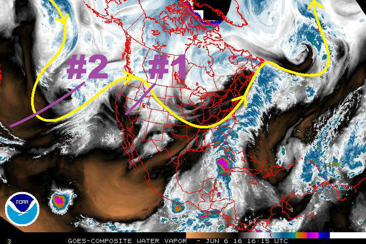
By late Saturday/early Sunday, the upper-level trough associated with Event #2 will be in a favorable position to bring in slightly cooler air as it breaks down the ridge. Subtropical moisture will be transported in from the south/southwest, bringing an increase in afternoon/evening thunderstorms. As the upper-low continues its trek east-northeastward, it will split in two, allowing a wave disturbance to pass over Colorado Monday and Tuesday. The best chance at heavy rain and potential flash flooding issues will be on those days. Behind this wave, the upper-level ridge will build across the western US in earnest, allowing sunshine to return and temperatures to climb. Before this period is over, there will be a few locations flirt with 95-100 degrees.
Event #1: Tuesday (06-07-2016) and Wednesday (06-08-2016)
No Apparent Flood Threat as Weak Upper-Level Low Exits Region
The weak upper-level wave that undercut the larger scale ridging will continue the active period through Wednesday as it moves slowly across the region. Each day will feature fewer showers and thunderstorms than the previous as the atmosphere dries out slightly and the upper-levels become less favorable to upward motion. A couple strong-to-severe storms will be possible across eastern Colorado during the afternoon/evening on Tuesday, with the main threats being gusty winds, hail, and lightning.

Event #2: Sunday (06-12-2016) through Tuesday (06-14-2016)
Elevated Flood Threat as Upper-Level Trough Breaks Down the Ridge
By late Saturday/early Sunday, south-southwesterly flow will transport subtropical moisture into the state, along with cooler air aloft, leading to an increase in afternoon/evening thunderstorms. As the upper-low continues its trek east-northeastward, it will split in two, allowing a wave disturbance to pass over Colorado Monday and Tuesday. Meanwhile, low-level upslope flow will transport moisture into eastern Colorado from the Great Plains. The best chance at heavy rain and potential flash flooding issues will be on those days as the best moisture/large-scale support overlap.