Issue Date: 6/13/2016
Issue Time: 11:30 AM

After what has been a fairly active first half of June, Mother Nature is going to dial it down and allow for summertime heat and sunshine to take over. Today’s active weather (discussed in this morning’s FTB) will be the last big hurrah for flooding threats for the foreseeable future, as this 15 day period features only two events, neither of which are accompanied by a flood threat. The first event is really the final day of the ongoing event, as the upper-level wave (purple line) will move out the state by Tuesday night. Moisture will be fairly low as drier air is pulled up from the south-southwest, limiting the threat of any heavy rainfall.
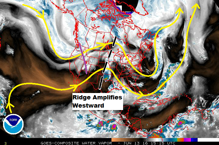
After Event #1, the ridge currently over the Central US will amplify westward, becoming the dominant weather feature for Colorado through Tuesday (June 21st). High temperatures will be hot during this period, and more than a few locations will reach into the upper 90s/near 100, especially across the Arkansas River Valley and far southeastern plains. Event #2 is the result of the dominant upper-ridge being flattened by an upper-level low passing across the northern Rockies. This would create a more “neutral” atmospheric state, allowing orographic influences to produce garden-variety showers/thunderstorms. After Event #2, the ridge amplifies again, leaving Colorado to bask in the summer sun.
Event #1: Tuesday (06-14-2016)
No Apparent Flood Threat as Moisture Exits
As the final day of the ongoing event, Tuesday will see the upper-level wave move east of the state by Tuesday night. Drier air will move in from the west-southwest, eliminating the threat of heavy rainfall. In fact, no location is expected to receive greater than 0.5 inches of total rainfall. Thus, no QPF shading on the precipitation map below.

Wednesday (06-22-2016) through Saturday (06-25-2016)
No Apparent Flood Threat as Upper Ridge Flattens
The dominant upper-level ridge will flatten as an upper-level trough slides across the Northern Rockies. This will allow for the diurnal cycle of showers/thunderstorms to kick back up thanks to orographic influences. At this time, it appears that moisture will be meager, leaving storms to produce more gusty winds and lightning than rain. Stay tuned for the next FTO on Thursday as we get another look at this period.