FTO 06-30-2016: Elevated Flood Threat Continues, 3 Events Total

Issue Date: 6/30/2016
Issue Time: 1:10 PM

Threat_Timeline_20160630

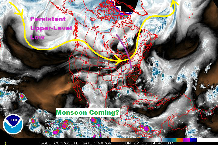
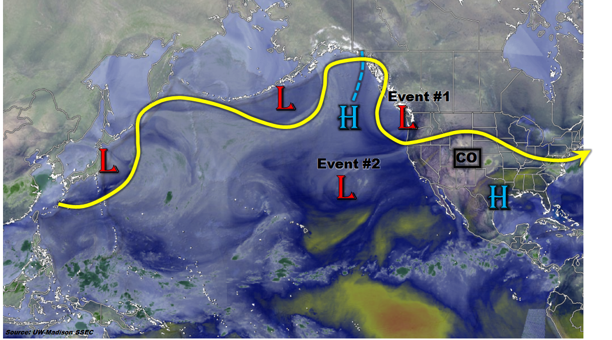
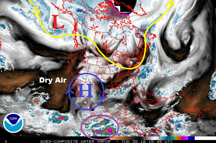
The upper-level low (denoted by a red “L” in the water vapor image) will shift slowly east through this coming weekend, ejecting weak disturbances into the mid-/upper-level flow. These disturbances will slide across the central/northern Rockies, working with the monsoonal moisture stuck underneath the high pressure ridge (blue “H”). Friday and Saturday (July 1/July 2) will be the wettest days of the first event, with moisture subsiding/shifting east slowly through the weekend.

By Monday (July 4), the moisture will subside and dry westerly flow will be overhead as high pressure builds across the region. This warming and drying period will continue through Thursday (July 7), only being broken up by a few afternoon high country showers/thunderstorms as sunshine and orographic effects work on residual moisture. This dry period will be hot, especially over the lower elevations of eastern Colorado. The Arkansas River Valley could see multiple afternoons with high temperatures over 100 F.

WV_20160630

After the warming/drying period, another moisture surge awaits (Event #2) for the end of next week. This surge will be of the Gulf moisture type, transported into the state by south/southeasterly flow across the US plains. Moisture will be confined essentially along/east of the Continental Divide, with the strongest storms over the eastern plains. A cool front will escort this moisture eastward again Sunday/Monday (July 10/July 11), bringing another dry/warming period to Colorado. By the middle-to-end of that week (July 12-15), there are hints of monsoonal moisture returning to the state as the eastern Pacific becomes active with tropical activity. This would mainly impact areas along and west of the Continental Divide. This surge will be discussed as Event #3 below.

Event #1: Friday (07-01-2016) through Sunday (07-03-2016)

Elevated Flood Threat Continues

Event #1 is a continuation of Event #1 as discussed in Monday’s FTO. Multiple disturbances will eject from the upper-level low, currently over the Gulf of Alaska (but shifting eastward), providing upper-level support for scattered-to-widespread showers and thunderstorms through Saturday. Moisture will begin to subside and slide eastward on Sunday as the upper-level ridge builds across the region and dry, westerly flow encroaches on Colorado. Due to these factors, Sunday will see a downtick in thunderstorm intensity/coverage as compared to Friday and Saturday.

Legend

Event #2: Friday (07-08-2016) through Sunday (07-10-2016)

No Apparent Flood Threat as Best Moisture Remains Over the Plains

A Gulf moisture surge is forecast to move into eastern Colorado late next week, continuing through the weekend, as south/southwesterly low-level flow asserts itself across the central US. The moisture will be essentially confined along/east of the Continental Divide. The strongest storms will likely remain east of I-25 and over the plains, especially the Northeast Plains. Due to the higher threshold for flash flooding over the plains, no flood threat is apparent. If sufficient moisture can move back into the Front Range/Urban Corridor, a flood threat could emerge. Stay tuned.

Legend

Event #3: Tuesday (07-12-2016) through Friday (07-12-2016)

No Apparent Flood Threat due to Uncertainty Surrounding Timing of Monsoon Surge

The strength of the summer ridge, as well as the timing of the tropical activity in the eastern Pacific will play a big role in the eventual emergence of Event #3. At this current time, it looks more probable to occur late in the week, with the best moisture/support for storms over the High Country. Due to the uncertainties surrounding this event, no precipitation map will be issued. Stay tuned for an update on this time period in Monday’s FTO.

FTO 06-27-2016: First Breath of Monsoonal Moisture

Issue Date: 6/27/2016
Issue Time: 12:12 PM

Threat_Timeline_20160627

A persistent upper-level low near the Gulf of Alaska will be the main player during this FTO period, accompanied by what appears to be the first real gasp of monsoonal moisture this season. The persistent low will keep the flow above Colorado west/northwesterly, ejecting disturbances across the region. Meanwhile, from the south/southwest, the North American Monsoon is awakening, beginning to transport moisture into the southwest US. As of this writing, Yuma, AZ, IPW is sitting above 1.4 inches. This moisture will work its way north-northeastward into the Four Corners region over the next few days.

WV_20160627

You’ll notice in the threat timeline at the top of the page, that Event #1 is a gradient of “No Apparent Threat” and “Elevated Threat.” I did this to give a visual note on how the threat will evolve. The first two days (Tuesday/Wednesday, June 28/29), will precede the deepest moisture moving in from the southwest. The end of the week and into the weekend (June 30 – July 3) will see the best combination of moisture/instability/disturbances, thus the transition to the “Elevated Flood Threat.” By Monday (July 4), the moisture will subside and dry westerly flow will be overhead, once again.

After the warming and drying period of Tuesday through Friday (July 5 – July 8), the next moisture surge awaits. Meanwhile, the persistent upper-level low will not be persistent anymore; instead, it will slide eastward along the US/Canada border. Depending on its eventual track will determine how much upper-level support is available for showers/thunderstorms. This will be monitored closely in the coming days. Also, there are hints in the extended range of tropical cyclone activity in the eastern North Pacific, which could have profound impacts in the extended range. As evidenced by the explanation above, there is some uncertainty surrounding the time frame of Event #2, so be sure and check back in with the FTO on Thursday.

Event #1: Tuesday (06-28-2016) through Monday (07-04-2016)

Elevated Flood Threat as First Monsoonal Moisture Surge Arrives

Awaiting the arrival of the main moisture surge, the first two days of this period will see progressively more shower/thunderstorm coverage. Temperature/dewpoint spreads in the low-levels suggest the heavy rain threat will be isolated through Wednesday. By Thursday, and lasting through Sunday, the moisture will be sufficiently deep enough to support scattered heavy rain events across much of the state as disturbances pivot across the region. Moisture will subside by late Sunday/early Monday, and dry westerly flow will be overhead.

Legend

Event #2: Saturday (07-09-2016) through Tuesday (07-12-2016)

No Apparent Flood Threat due to Uncertainty Surrounding Key Features

The upper-level low’s movement, timing of the next moisture surge, and any potential tropical cyclone activity in the eastern North Pacific are key factors in the extended range. Uncertainty exists with all three, and all will be monitored closely. Regardless, this looks to be the next opportunity for a wet period. Keep in mind that the precipitation map below represents the current thinking and will likely need adjustments moving forward. Stay tuned.

Legend

FTO 06-23-2016: Active Period Underway East of the Divide; Warm and Mainly Dry West; Jury Still Out On Monsoon Watch

Issue Date: Thursday, June 23rd, 2016
Issue Time: 2:20PM MDT
Valid Period: June 24th through July 8th

threat_timeline

Today’s water vapor image over the North Pacific Ocean and North American continent, below, shows an active pattern with numerous low-pressure centers embedded in the jet stream. Of these, the disturbance currently entering the Pacific Northwest and the cut-off low southwest of California appear to play prominent roles in our state’s weather over the next two weeks. Also of interest is the high-pressure center in the southern Gulf of Alaska. This feature will slowly move eastward and then park itself roughly over the climatologically preferred position centered on western North America.

wv_markup

In fact, long-range guidance suggests that the mean circulation over the next 7-14 days will be marked by this high-pressure ridge. Using the Climate Prediction Center’s best analogs of forecasted mid-level flow centered on day 7 (June 30th), the maps below show that the anomalous ridge should assume a position roughly centered over Washington state and British Columbia. This pattern is far enough northwest of Colorado that the eastern part of our state should see its fair share of weather patterns that transition around this ridge. For example, the right map below shows the composite precipitation anomalies that occur during the forecasted flow. Note that historically, eastern Colorado, in particular the southeast, receives above average precipitation during this kind of flow. Lastly, we are also keeping a close watch on the southwest monsoon, which at this time appears to be slightly behind schedule. There are some indications of several monsoon-type disturbances over the next 15 days, however, just like last Monday’s FTO this is no the “most likely outcome”. With that said, it appears that western Colorado will continue to see generally dry and warm weather until the monsoon flow can get established.

analog_compsWe have identified three precipitation events over the next 14-day period. The first two events are very similar to those identified by the last FTO. Below, each event is described in detail.

Event #1: Friday (6-24-2016) through Saturday (06-25-2016)

No Apparent Flood Threat but widespread light to moderate rainfall possible

A large-scale disturbance, currently entering the northwest coast of US will come ashore and quickly  trek across the northern tier of states on Friday and Saturday. It appears that each day will see a wave of afternoon shower and thunderstorm activity. The impacted region on Friday will be northeast Colorado, while on Saturday, the southeast part of the state will see the most widespread rainfall. Given that this disturbance will only graze Colorado, upper-level dynamics will be rather limited. The main drivers will be a surface cool front and solar insolation. Isolated pockets of heavy rainfall are possible east of the Divide, but in general we anticipate up to 1.25 inches of rainfall. Thus, an elevated flood threat is not warranted at this time, and the finer details will be covered by ensuing Flood Threat Bulletins.


Legend

Event #2: Tuesday (6-28-2016) through Thursday (06-30-2016)

No Apparent Flood Threat

For several days following Event 1, the ridge is expected to re-exert dominance over the Rocky Mountain states. Then, current guidance suggests that the cut-off low seen in the water vapor image will eventually be absorbed into the main flow and work its way around the anticipated northwest US ridge. Again, this will provide a “northwest flow” event, similar to Event 1. It is difficult for such events to produce prolonged and widespread heavy rainfall because upslope flow is limited and followed by downsloping westerly winds after event passage. Nonetheless, we expect several rounds of thunderstorms Tuesday and Wednesday and residual moisture to provide some higher elevation storms on Thursday. The target areas will be mainly east of the Continental Divide. As with Event #1, forecasted precipitation is expected to stay at or below 1.5 inches. Thus, no elevated threat is warranted at this time.

Legend

Event #3: Wednesday (7-7-2016) through Thursday (7-8-2016)

No Apparent Flood Threat

Another lull is expected after Event #2 where the ridge will strengthen and provide warm and dry weather for Colorado, especially on the western slope. At this time, guidance again suggests a breakdown of the expected ridge with another “northwest flow” event possible. At this time, the chances of this occurring are too low to produce a precipitation map. However, it appears that northern and eastern Colorado will be most under threat. The western part of the state is expected to remain very warm and mostly dry.

FTO 06-20-2016: More Active Period In Store, But Rainfall Coverage May Be Limited

Issue Date: Monday, June 20th, 2016
Issue Time: 2:10PM MDT
Valid Period: June 21st through July 5th

threat_timeline

It has been a warm and rather dry start to summer in Colorado. The map below shows the temperature anomaly since June 1st, with 3-8F values common across our state. Regarding precipitation, most of the state is below normal for June, with isolated pockets of plentiful rainfall limited to parts of the Southeast and Northeast Plains. Fortunately, May precipitation was at or above average for many, thus drought concerns have been kept at bay thus far.

tempanom

The warm temperatures at the surface have been associated with clockwise circulation anomaly in the upper atmosphere, as shown below. This promotes subsidence above the boundary layer and limits widespread rainfall. Note that it does not preclude rainfall altogether as we saw yesterday (6/19/2016) when over 1 inch of rain fell from a storm that formed almost directly under the heart of the ridge.

hgt_anomLooking forward, we see a more active weather, and overall cooler (though “cool” in the summer is relative!) pattern for eastern Colorado. Meanwhile, western Colorado will continue to stay warm as the ridge intensity pulses. In the western part of the state, we turn our eyes farther southwest to see when the southwest North American monsoon may start. Climatologically, the last week of June and first week of July typically sees a marked increase in low-level moisture across the southwest. For example, Phoenix’s average dew point temperature goes from about 39F on June 21st to 55F by June 8th. Up until now, moisture has been certainly lacking with central Arizona breaking high-temperature records accompanied by very little humidity. Looking forward, there are some indications that monsoonal moisture may make it northward for the July 4th weekend. However, this is not the “most likely” outcome at this point in time.

Over the next 14 days, we have identified three organized precipitation events that are expected to impact the state. At this time, each event is categorized as “No Apparent Flood Threat”. Below, each event is described in more detail.

Event #1: Friday (6-24-2016) through Saturday (6-25-2016)

No Apparent Flood Threat as fast motion of disturbance will likely limit heavy rainfall

A moderate-sized disturbance, currently off the coast of North America will come ashore and dent the ridge over the Rocky Mountain states. At least one wave of showers and thunderstorms will occur during the Friday – Saturday timeframe. The locations most likely to be impacted are the Front Range mainly north of Colorado Springs and the Northeast Plains. Farther south, rainfall coverage appears to be limited given the position of the ridge. Up to 1.25 inches of rainfall, along with gusty westerly winds, is possible with this event. An elevated threat is not warranted at this time.


Legend

Event #2: Tuesday (6-28-2016) through Thursday (6-30-2016)

No Apparent Flood Threat because ridge strength will limit organized heavy rainfall

For several days following Event 1, the ridge is expected to re-exert dominance. Then, current guidance suggests it will weaken on its eastern periphery and allow more of a northerly flow to affect eastern Colorado. Again, this kind of situation is not particularly conducive to widespread heavy rainfall because the strength and duration of moisture return is insufficient. Nonetheless, enough instability should be in place for some moderate rainfall amounts, up to 1.5 inches, in the Front Range, Urban Corridor and Northeast Plains during this period.


Legend

Event #3: Monday (7-4-2016) through Tuesday (7-5-2016)

No Apparent Flood Threat but rainfall possible statewide

Another lull is expected after Event #2 where the ridge will strengthen and provide warm and dry weather for Colorado. Thereafter, in time for Independence Day, there are several possible scenarios painted by guidance today. First, the ridge weakens on its eastern periphery, like Event 2, and allows for small disturbances to propagate southward (east of the Continental Divide). Second, there are also indications that the southwest US heat low will finally be strong enough to begin transporting monsoonal moisture northward. Given the spread in guidance, there is no need for an elevated flood threat at this time. Also, given the dichotomous nature of these scenarios (i.e. if the first scenario occurs, western CO stays dry; if the second occurs, eastern CO stays dry), we do not include a precipitation map for this event.