Issue Date: Thursday, June 23rd, 2016
Issue Time: 2:20PM MDT
Valid Period: June 24th through July 8th
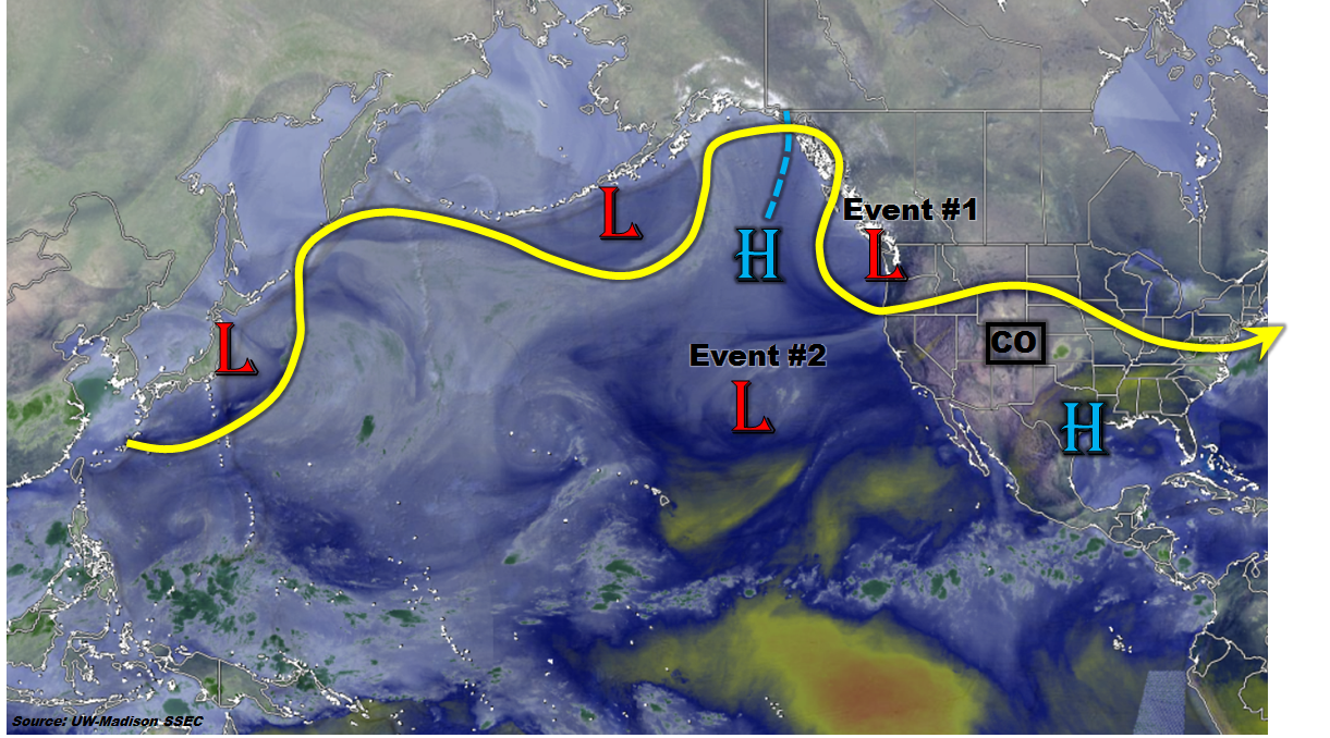
Today’s water vapor image over the North Pacific Ocean and North American continent, below, shows an active pattern with numerous low-pressure centers embedded in the jet stream. Of these, the disturbance currently entering the Pacific Northwest and the cut-off low southwest of California appear to play prominent roles in our state’s weather over the next two weeks. Also of interest is the high-pressure center in the southern Gulf of Alaska. This feature will slowly move eastward and then park itself roughly over the climatologically preferred position centered on western North America.
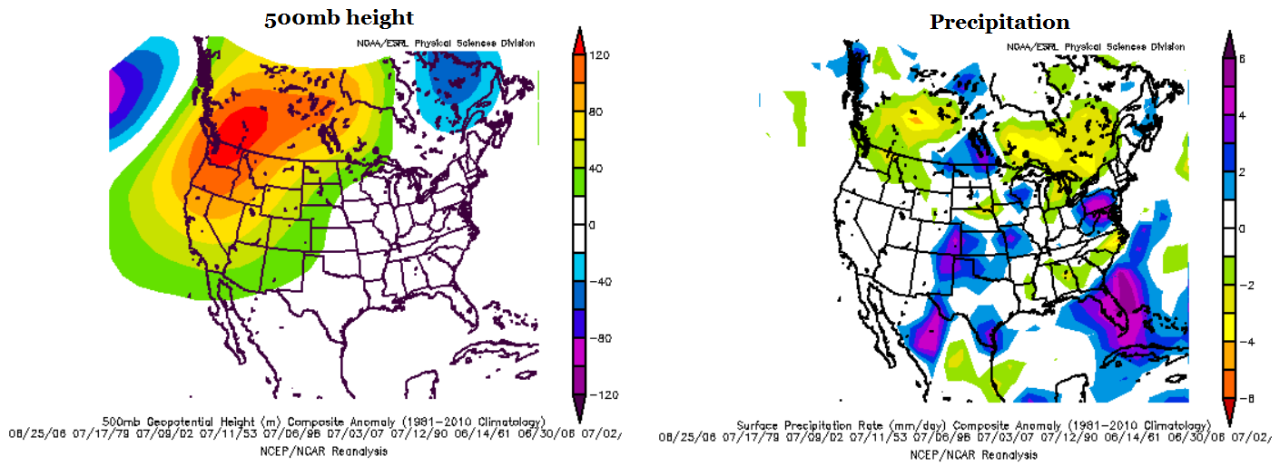
In fact, long-range guidance suggests that the mean circulation over the next 7-14 days will be marked by this high-pressure ridge. Using the Climate Prediction Center’s best analogs of forecasted mid-level flow centered on day 7 (June 30th), the maps below show that the anomalous ridge should assume a position roughly centered over Washington state and British Columbia. This pattern is far enough northwest of Colorado that the eastern part of our state should see its fair share of weather patterns that transition around this ridge. For example, the right map below shows the composite precipitation anomalies that occur during the forecasted flow. Note that historically, eastern Colorado, in particular the southeast, receives above average precipitation during this kind of flow. Lastly, we are also keeping a close watch on the southwest monsoon, which at this time appears to be slightly behind schedule. There are some indications of several monsoon-type disturbances over the next 15 days, however, just like last Monday’s FTO this is no the “most likely outcome”. With that said, it appears that western Colorado will continue to see generally dry and warm weather until the monsoon flow can get established.
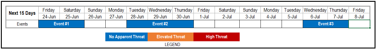
 We have identified three precipitation events over the next 14-day period. The first two events are very similar to those identified by the last FTO. Below, each event is described in detail.
Event #1: Friday (6-24-2016) through Saturday (06-25-2016)
No Apparent Flood Threat but widespread light to moderate rainfall possible
A large-scale disturbance, currently entering the northwest coast of US will come ashore and quickly trek across the northern tier of states on Friday and Saturday. It appears that each day will see a wave of afternoon shower and thunderstorm activity. The impacted region on Friday will be northeast Colorado, while on Saturday, the southeast part of the state will see the most widespread rainfall. Given that this disturbance will only graze Colorado, upper-level dynamics will be rather limited. The main drivers will be a surface cool front and solar insolation. Isolated pockets of heavy rainfall are possible east of the Divide, but in general we anticipate up to 1.25 inches of rainfall. Thus, an elevated flood threat is not warranted at this time, and the finer details will be covered by ensuing Flood Threat Bulletins.

Event #2: Tuesday (6-28-2016) through Thursday (06-30-2016)
No Apparent Flood Threat
For several days following Event 1, the ridge is expected to re-exert dominance over the Rocky Mountain states. Then, current guidance suggests that the cut-off low seen in the water vapor image will eventually be absorbed into the main flow and work its way around the anticipated northwest US ridge. Again, this will provide a “northwest flow” event, similar to Event 1. It is difficult for such events to produce prolonged and widespread heavy rainfall because upslope flow is limited and followed by downsloping westerly winds after event passage. Nonetheless, we expect several rounds of thunderstorms Tuesday and Wednesday and residual moisture to provide some higher elevation storms on Thursday. The target areas will be mainly east of the Continental Divide. As with Event #1, forecasted precipitation is expected to stay at or below 1.5 inches. Thus, no elevated threat is warranted at this time.
Event #3: Wednesday (7-7-2016) through Thursday (7-8-2016)
No Apparent Flood Threat
Another lull is expected after Event #2 where the ridge will strengthen and provide warm and dry weather for Colorado, especially on the western slope. At this time, guidance again suggests a breakdown of the expected ridge with another “northwest flow” event possible. At this time, the chances of this occurring are too low to produce a precipitation map. However, it appears that northern and eastern Colorado will be most under threat. The western part of the state is expected to remain very warm and mostly dry.